VIDEO: Thanksgiving Weather; “Interesting” Open To December…
You must be logged in to view this content. Click Here to become a member of IndyWX.com for full access. Already a member of IndyWx.com All-Access? Log-in here.
You must be logged in to view this content. Click Here to become a member of IndyWX.com for full access. Already a member of IndyWx.com All-Access? Log-in here.
 Highlights:
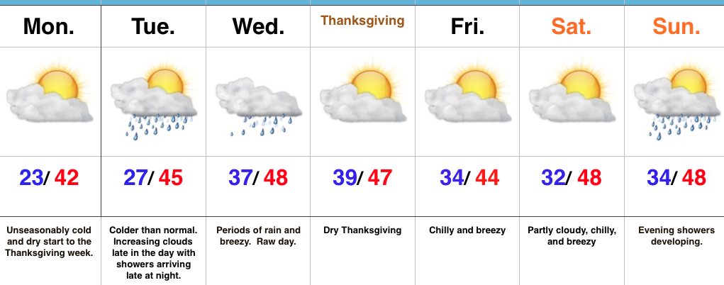
Active Week…Some folks across central Indiana are waking up to temperatures in the upper 10s this morning (looking at you Crawfordsville) and most everyone else is being greeted by lower to middle 20s out the door! It’s a very cold start to the day. Thankfully, dry conditions will remain today and through the daytime Tuesday. Clouds will be on the increase Tuesday, but we should hold off on rain until late at night. Unfortunately, the big travel day Wednesday will feature periods of rain and blustery, chilly conditions. It’ll be a raw day.
We’ll dry things out for Thanksgiving, itself, along with seasonable temperatures. Reinforcing chilly air will blow into town Black Friday and our next storm system of interest will arrive Sunday. Most of the day Sunday will feature dry conditions before rain arrives on the scene by evening.
Upcoming 7-Day Precipitation Forecast:
 Highlights:
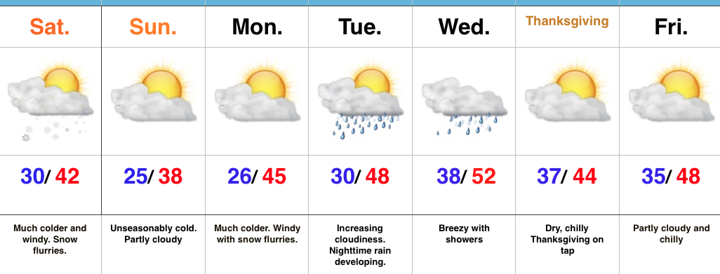
Pull Out Those Heavier Coats…Last night’s cold front hit with authority and will likely be looked back on as the “game changer” between the warm, quiet fall we enjoyed and colder, more active times ahead. Today is much colder with snow flurries and scattered snow showers. Gusty NW winds will feature wind chills in the 20s through the daytime before falling into the 10s tonight.
Calm, cold weather will continue into early next week before our next storm system blows into town Tuesday evening. Clouds will increase through the day Tuesday and rain will arrive at night. The big travel day before Thanksgiving looks blustery and wet with showers (especially during the first half of the day). We’ll get the system out of here to allow for a dry, chilly Thanksgiving.
Looking ahead, another system of “interest” is on deck late next weekend or early the following week. Timing and details are far from etched in stone with this being 7+ days out, but the potential is there for this to feature a wintry component…
Upcoming Precipitation Forecast:
You must be logged in to view this content. Click Here to become a member of IndyWX.com for full access. Already a member of IndyWx.com All-Access? Log-in here.
 Highlights:
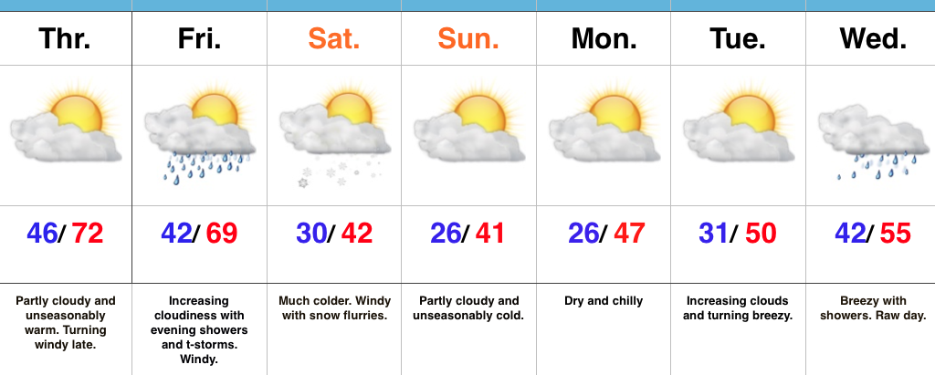
Changeable Weather…If you don’t find a way to get outside today something is wrong. Let the boss know IndyWx.com gave you permission to spend an extended lunch outdoors today. 🙂 Sunny skies and unseasonably warm temperatures will be with us through the day, along with an increasingly gusty afternoon wind.
Clouds increase Friday and showers develop Friday evening. A couple of stronger thunderstorms are also possible as the front sweeps through the state. While we’re not forecasting a widespread severe wind potential, one or two strong and gusty storms are possible. The front will hit like a wall Friday night and feature an abrupt wind shift and plummeting temperatures. That high Saturday in the lower 40s will be predawn as most of the day will be spent in the 30s with gusty winds and snow flurries. Steadier snow squalls will be found across north and northeast IN.
Dry, chilly weather will be with us for the remainder of the weekend, continuing into the beginning of the Thanksgiving week ahead. Our next storm system is slated for the big travel day Wednesday. Expect showers and gusty winds followed by colder weather for Thanksgiving, itself.
Upcoming 7-Day Precipitation Forecast: