VIDEO: Accumulating Snow Tuesday…
You must be logged in to view this content. Click Here to become a member of IndyWX.com for full access. Already a member of IndyWx.com All-Access? Log-in here.
You must be logged in to view this content. Click Here to become a member of IndyWX.com for full access. Already a member of IndyWx.com All-Access? Log-in here.
 Highlights:
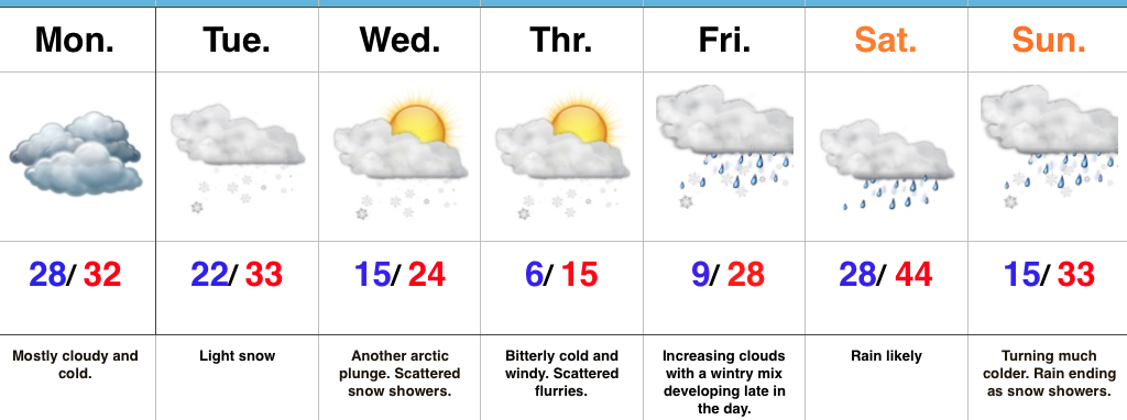
Bitterly Cold Week Ahead…We’ll kick off the work week with mostly dry, but mostly cloudy and continued cold conditions. Be careful if traveling early in the morning as some refreezing may take place across central IN during the overnight.
Reinforcing arctic air will begin to blow into town mid week and an area of light snow may precede this next arctic punch to the gut Tuesday. Scattered snow showers and flurries will fly in the bitterly cold, arctic, air mass Wednesday and Thursday. Along with highs only in the teens Thursday, expect below zero wind chills.
Eyes will then shift to the end of the week as our next storm of significance approaches. This storm appears to be stronger than this past weekend’s system, but similar to this weekend’s overall pattern, we expect a “mild up” and mostly a liquid event across central parts of the state. The primary reason? Lack of high latitude blocking to keep the storm track south (more on that in another post later tonight or Monday). Add in a “feisty” southeast ridge that keeps flexing it’s muscle and you have the makings for what’s likely another cutter to the Lakes. Unlike this current event, we will have to keep an eye on a potential second wave of moisture moving along the front Sunday as the arctic air returns.
Upcoming 7-Day Precipitation Forecast:
 Highlights:
Snow Develops Tonight…Today is mostly dry and cold, including a mostly cloudy sky. Clouds will lower and thicken this afternoon and give way to light snow late tonight across north-central Indiana and points north. As milder air is pulled north Sunday, snow will transition to a wintry mix and eventually a cold light rain across central Indiana. Further north, this will remain mostly snow before transitioning to a wintry mix. Precipitation will end for everyone Sunday night.
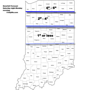
Here’s the current thinking on storm total snowfall with this event. (Click to enlarge).
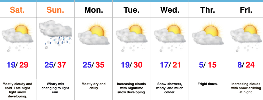
 We’ll open the work week with dry and cold conditions, but all eyes will be on the next arctic front by this time. It’ll blast through here the middle of the week with even colder air than what we’re currently “enjoying.” 🙂 Expect sub-zero wind chills mid week. Snow showers and gusty winds remain in the mid week forecast and will require fine tuning as we draw closer. A quick note, medium range modeling and beyond will really struggle in run-to-run consistency with such a pattern. The slightest difference in handling respected upper air energy will lead to dramatic changes in the sensible weather the modeling paints. There’s no sense in changing the forecast daily (or, in some cases, multiple times per day, only to change it back to where we began as time draws closer).
Finally, yet another winter weather maker awaits for the end of the week. Clouds will be on the increase Friday with snow (or a wintry mix) developing at night. It’s a busy, cold pattern…
Upcoming 7-Day Precipitation Forecast:
 Highlights:
Wintry Hits Are Lining Up…Fresh arctic air combined with even the slightest bit of upper energy can produce an overachieving snow shower event. As was the case overnight with many neighborhoods through central IN accumulating a coating to around 1″ of snow. Take it slow this morning and leave extra time to reach your destination. Bitterly cold air continues to wrap up the work week and head into the weekend (keep in mind our average high and low are in the lower 40s and middle 20s, respectfully). As we look through the upcoming 7-day period, temperatures will run significantly below average throughout.
Our next storm system is dialed up this weekend. Clouds will increase as we progress through the second half of the day Saturday and light snow will develop late Saturday night into Sunday morning. As the area of low pressure tracks from northern MO into the Great Lakes, we’ll get into a milder southerly flow Sunday. This will help bring in enough warm air to transition snow to rain during the day Sunday. Beforehand, a light accumulation of snow is possible in and around Indianapolis (more on potential amounts this time tomorrow). Heavier snow will pile up across northern Indiana. Precipitation should shut off rather quickly Sunday night and we’ll be in between systems Monday.
By Tuesday, our attention will turn northwest as we await the arrival of another arctic cold front. As the front moves in, modeling suggests multiple waves of energy move along the boundary, throwing moisture into the cold air and creating a rather snowy scenario as we progress through mid week. We need to get through the weekend first, but this could also be an impactful event. Very windy and frigid conditions move in Wednesday into Thursday, including sub-zero wind chills. Additional snow chances await next weekend…
Upcoming 7-Day Precipitation Forecast:
 Highlights:
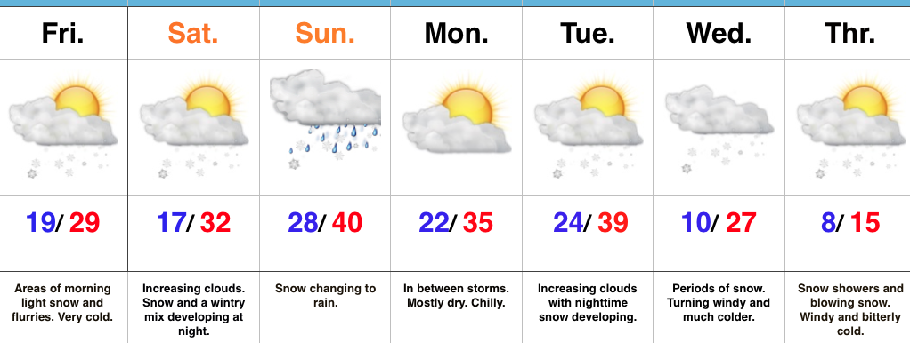
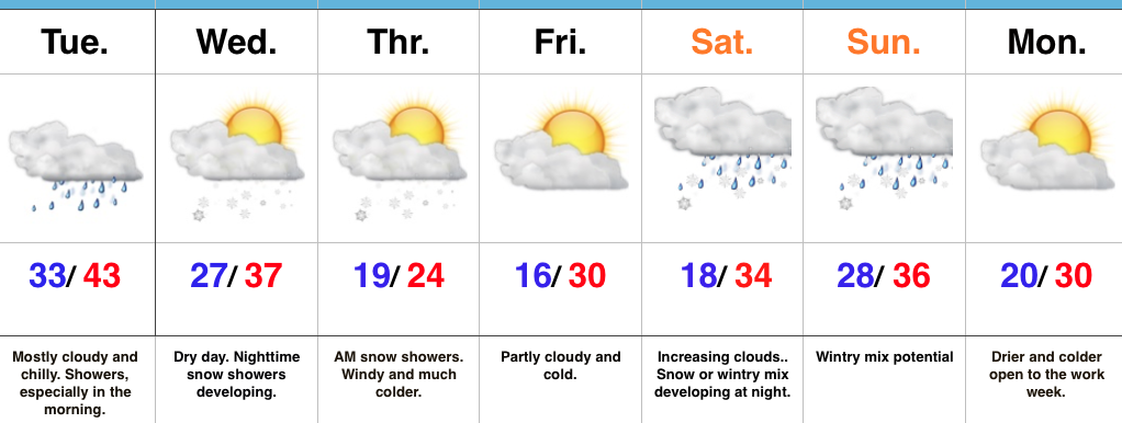
Find That Heavier Winter Gear…Our next area of low pressure will push northeast between now (north-central Gulf Coast) and Tuesday night (central Appalachians). Most of the widespread rain will fall across southeast IN this go around, but enough moisture will spread west to result in scattered to numerous showers Tuesday morning. With temperatures in the lower to middle 30s, don’t be surprised if a sleet pellet or snow flake mix in at times. All in all, expect another “raw” day. Drier times will await for the evening rush home.
Wednesday will feature mostly dry conditions, but the arctic hounds will be howling to our northwest. Snow showers will precede this arctic blast Wednesday night and Thursday morning and may be enough to accumulate for some. While models remain drier than we’d expect (given the overall set-up), we may “eek” out just enough moisture to coat the ground up for some. Thursday will be a frigid day, including wind chills in the single digits. Heavier winter gear will be required to wrap up the work week.
The weekend features more “fun and games” as an area of low pressure attacks stale cold air left over from the late week arctic push. Is the cold air deep enough to create wintry problems or does the southerly flow help scour out the chill and lead to more of a liquid event. Stay tuned.
Upcoming 7-Day Precipitation Forecast: