Here’s our snowfall forecast. Most of what accumulates through the heart of the 8″ to 12″ zone and points south will fall with “round 2” Wednesday night and Thursday. This morning’s video update has the details!
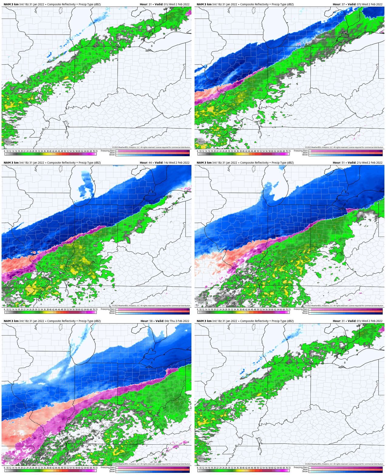
Central Indiana continues to prep for a major winter storm, and rightfully so. Today’s model guidance continues to suggest we look at (2) waves of heavier moisture in the Tuesday evening to Thursday evening time period. There’s also growing confidence that at least for the bulk of central Indiana, including the I-70 corridor, this will be mostly a rain or snow event with a brief period of mixing (especially compared to what forecast models were showing only a couple of days ago). That’s not to say that south-central and southern Indiana won’t potentially have to deal with a more extended period of sleet and/ or freezing rain, but thinking continues to increase here that the depth of the cold will allow for a faster transition from rain to snow through the heart of central Indiana, including Indianapolis, especially when compared to what was shown on guidance 24-48 hours ago.
Let’s time things out:
Clouds will be on the increase Tuesday morning, lowering and thickening towards lunchtime and light rain will begin to develop across far western and northwestern Indiana by late morning. Rain will pick up in intensity through the evening hours and eventually overspread more of central Indiana during the overnight. As this takes place, cold air will begin to press southeast, allowing far northwestern and northern Indiana to change to a wet snow after midnight. Periods of heavy snow can be expected for north-central and northern Indiana Wednesday morning. Meanwhile, rain is likely to begin mixing with and changing to sleet across the northern Indianapolis ‘burbs around, or just after, sunrise. Things get a little more tricky in the city, itself, but the cold, arctic air should continue to ooze south through the day, allowing Indianapolis to begin to transition to a wintry mix of sleet, freezing rain, and snow during the early to mid afternoon on Wednesday. (By this time, I expect northern ‘burbs, including Zionsville, Fishers, Westfield, etc. and points north to be fully in the snow show). Areas south of the city to the Ohio River will likely remain a cold rain through sunset Wednesday.
The first of (2) waves of heavy precipitation will begin to impact the state Tuesday into Wednesday.
While we’ll hold until Tuesday morning for our official first stab accumulation map, snowfall will likely pile up to the tune of 8″ to 12″ with this first wave of moisture from north-central Indiana and points north to the MI border. This includes Lafayette, Kokomo, Marion and points north. It should also be noted that the initial push of snow will likely fall close to a 10:1 to 15:1 ratio (these ratios will increase as the arctic air pours into “round 2”). For areas closer to the city, amounts will vary more significantly with round 1, based on the precise transition from the icy mixture to snow. It’s entirely possible to be looking at a situation that features little to no snow accumulation south of Indianapolis, with several inches of wet snow and sleet from the city, itself, and points north that encompass the northern ‘burbs by Wednesday evening.
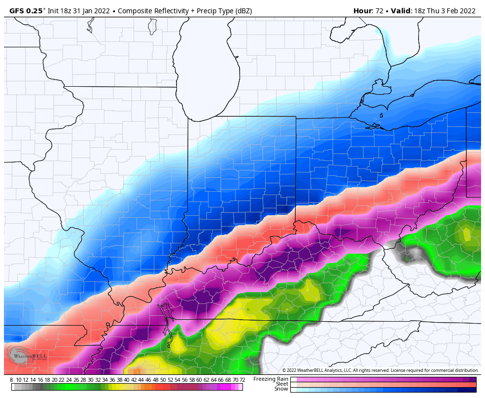
While there could be a brief “lull” in the action Wednesday evening, we’re expecting widespread moisture to once again overspread the region during the overnight and into Thursday. As cold air continues to drain south, this is when the southern half of the state will begin to get in on the wintry action. Wave 2 will lead to an expanding shield of moisture during the overnight hours, becoming heavy at times across the entire region early Thursday morning, continuing into the afternoon hours. While there will likely be some mixing issues downstate (sleet and freezing rain), we anticipate even south-central portions of the state (including Vincennes, Bedford, Seymour) to be mostly snow with this 2nd wave. Snow will likely be heavy at times Thursday morning into the afternoon hours across the area, including central and north-central Indiana, with several inches of additional snow accumulation during this time. The significant moisture is then expected to pull off to the east just before sunset for the city, itself, before departing a couple hours later across southern Indiana (more towards 6p to 7p). By this point, a “plowable,” accumulating snow should make it as far south as the OH River, with a “big snow” from south-central Indiana northward.
“Round 2” will feature more in the way of wintry precipitation all the way south into the northern TN Valley.
Couple things to keep in mind with this system:
I. It’s a drawn out, 2-part event that’s likely to add up to one of the bigger, more impactful winter weather makers over the past several years across the entire state.
II. Snow ratios that will start out closer to 10:1 will likely grow closer to 20:1 for central and northern IN during “round 2.” This will certainly produce a fluff factor and allow for some blowing and drifting issues to develop during the day Thursday and Thursday night, especially on east-west roadways.
III. Intensity of precipitation will be tough for road crews to keep up with during the height of the storm Wednesday morning into the afternoon and again overnight Wednesday into Thursday afternoon. We’d encourage necessary travel and errands being completed tomorrow.
IV. Bitterly cold air will pour in here for the weekend, including temperatures that will likely drop into the double-digit below zero category by Saturday morning. This will complicate snow removal efforts.
Much more in the AM, friends! Have a relaxing evening!
You must be logged in to view this content. Click Here to become a member of IndyWX.com for full access. Already a member of IndyWx.com All-Access? Log-in here.
You must be logged in to view this content. Click Here to become a member of IndyWX.com for full access. Already a member of IndyWx.com All-Access? Log-in here.
You must be logged in to view this content. Click Here to become a member of IndyWX.com for full access. Already a member of IndyWx.com All-Access? Log-in here.