Updated 01.26.24 @ 7:38a A quiet but gloomy and unseasonably mild close to the work week can be expected before a weak system skirts the region Saturday evening into predawn…
You must be logged in to view this content. Click Here to become a member of IndyWX.com for full access. Already a member of IndyWx.com All-Access? Log-in here.
Permanent link to this article: https://indywx.com/video-wet-snow-accumulation-for-parts-of-the-region-sunday-morning-pattern-evolution-into-early-march/
Updated 01.25.24 @ 7:36a Dense fog is present yet again this morning, but at least we’re not dealing with heavy rain. That changes later this evening as a slug of…
You must be logged in to view this content. Click Here to become a member of IndyWX.com for full access. Already a member of IndyWx.com All-Access? Log-in here.
Permanent link to this article: https://indywx.com/video-source-region-change-for-our-storm-systems-between-now-and-next-week-establishing-a-bar-on-just-how-cold-we-get-next-month/
Overall, we don’t have any changes to our ongoing ideas from last night’s video. If you didn’t have an opportunity to catch that, we encourage you to do so as it highlights our medium and long range thoughts in more detail.
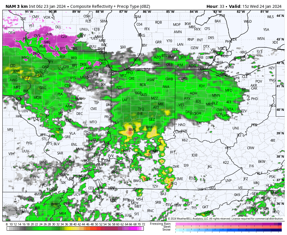
The focus will change from one of ice to periods of rain (and dense fog) through the remainder of the week. We note multiple waves of more widespread rain that will ride into central Indiana over the next few days. While it won’t rain the entire time, an extended period of gloomy conditions will unfortunately be with us as we navigate the next few days and kick off the weekend.
Periods of rain can be expected through the remainder of the week.
Speaking of the weekend, we continue to closely monitor an area of low pressure that appears to take a classic track for a heavy snow dump around these parts. The problem? Cold air is fleeting and it’ll take the perfect combination of track, timing, and precipitation rates to generate anything meaningful from a wintry standpoint, locally. As of now, we favor this “sweet spot” to lay just north of our immediate area, but we’ll continue to closely monitor.
That brings us to our final point this morning and that’s wanting to ensure we drive home the idea here of an overall milder to significantly milder than normal pattern over the upcoming 10-14 days as a whole. While we’re incredibly bullish on winter’s return, we’re equally as impressed by this overall milder signal in the short to medium term.
You must be logged in to view this content. Click Here to become a member of IndyWX.com for full access. Already a member of IndyWx.com All-Access? Log-in here.
Updated 01.22.24 @ 6:56a While portions of western and northern IN will see some light sleet and freezing rain this morning, the concern here remains on what lies ahead tonight…
You must be logged in to view this content. Click Here to become a member of IndyWX.com for full access. Already a member of IndyWx.com All-Access? Log-in here.