Updated 04.03.24 @ 7:40a Clouds and showers (even embedded thunder by this afternoon) will transition to wet snow tonight into Thursday morning. The wet snow will fall heavily enough to…
You must be logged in to view this content. Click Here to become a member of IndyWX.com for full access. Already a member of IndyWx.com All-Access? Log-in here.
Updated 03.25.24 @ 7:25a While the work week will open on a quiet note today, we’ll really notice an uptick in winds by afternoon and these will only continue to…
You must be logged in to view this content. Click Here to become a member of IndyWX.com for full access. Already a member of IndyWx.com All-Access? Log-in here.
Permanent link to this article: https://indywx.com/video-batten-down-the-hatches-keeping-an-eye-on-a-line-of-potentially-strong-severe-storms-tuesday-pm/
Updated 03.23.24 @ 10:51a A quiet weekend will turn more active as we open the new work week. We’re tracking this system and another storm late in the week. Both…
You must be logged in to view this content. Click Here to become a member of IndyWX.com for full access. Already a member of IndyWx.com All-Access? Log-in here.
Permanent link to this article: https://indywx.com/video-weekend-sunshine-tracking-2-storm-systems-in-the-week-ahead-and-looking-at-the-early-april-pattern/
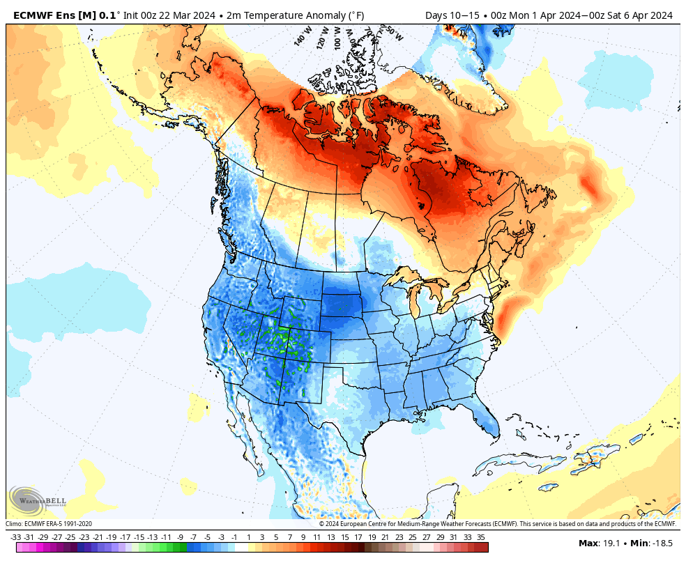
The ‘mean’ trough position will take up shop across the western portion of the country over the upcoming week before shifting into the East in the 10-15 day period. We reiterate while the balance of the upcoming 2 weeks will run cooler than normal, we don’t see anything significantly colder than normal on the horizon and also plenty of transitional warmth ahead of approaching storms.
Note how the trough shifts east late in the period.
Day 1-5Day 5-10Day 10-15
Back to the immediate term, we’ll only see a few light showers later this afternoon (trace to 0.10”). Greatest coverage should arrive after lunch, continuing into mid-afternoon. Again, “light” is the key word.
Colder air arrives for the weekend, itself. We can expect mid to upper 20s both Saturday and Sunday morning.
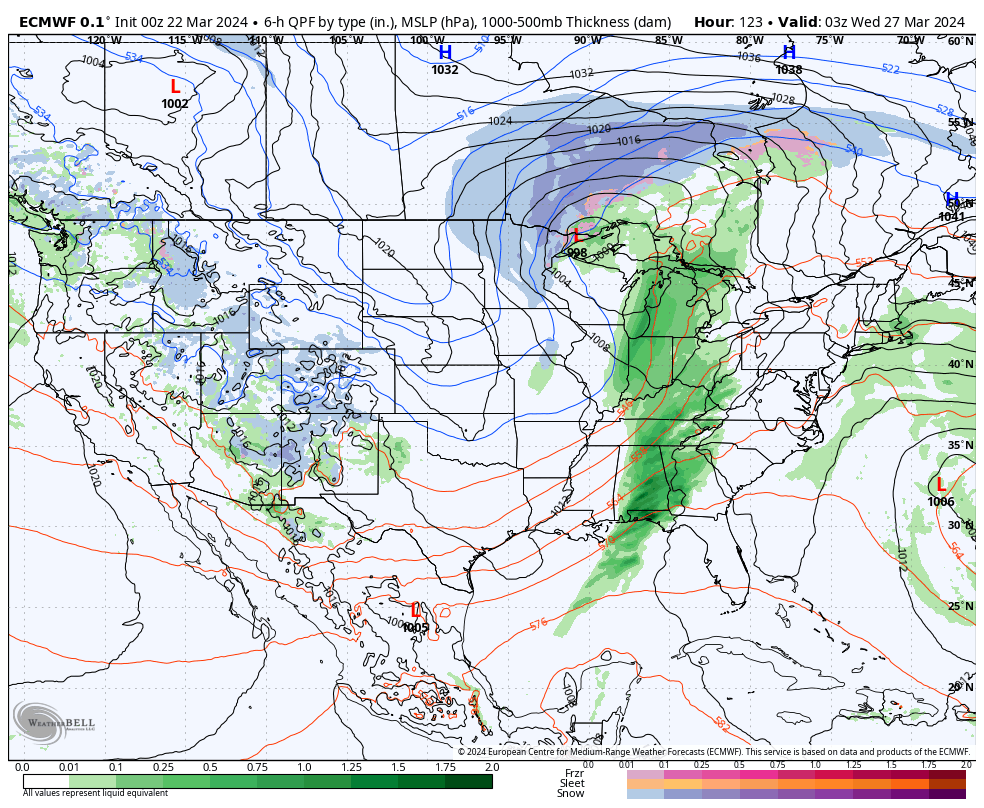
A new, stronger, storm will blow into town with more in the way of widespread heavier rain and thunder Monday night into the day Tuesday.
Another system will follow late week and next weekend.
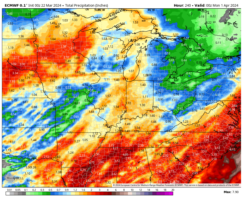
1” to 2” is a good bet across the greater region by next Sunday. (The bulk of this falls with our Monday night and Tuesday system).
Updated 03.21.24 @ 7a The area will receive a glancing blow from our late week low pressure “tag team” that will deliver light rain Friday (most areas will be under…
You must be logged in to view this content. Click Here to become a member of IndyWX.com for full access. Already a member of IndyWx.com All-Access? Log-in here.