You must be logged in to view this content. Click Here to become a member of IndyWX.com for full access. Already a member of IndyWx.com All-Access? Log-in here.
Category: PNA
Permanent link to this article: https://indywx.com/video-week-ahead-outlook-what-awaits-for-mid-month/
Dec 02
More December Rumblings: MJO, PNA, EPO Don’t Favor Sustained Cold (Yet)…
For those that may not have had an opportunity to review our December Outlook over the busy Thanksgiving weekend, you can do so here.
This morning, we wanted to again review our forecast and provide further context behind our overall active, warmer than normal call for the month as a whole.
Before digging in to those additional details, here’s our 2019 December Forecast:


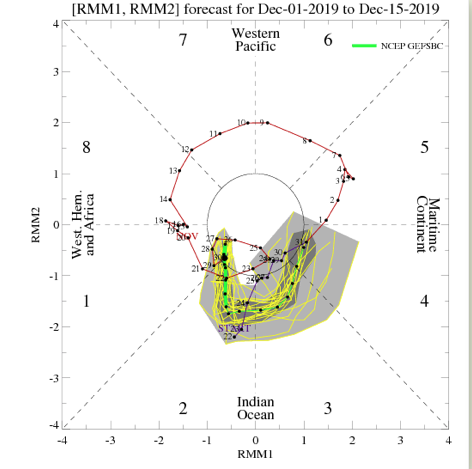
The “baseline” of this slightly-moderately milder than normal December is due to what appears to be the tendency of the MJO to run into the warmer phases (remember, Phases 3-5 this time of year argue for warmer than normal conditions across the East). The most updated MJO forecast continues to stay the course here.

At least through mid-December, the PNA and EPO are also forecast to be in phases that would support warmer than normal conditions across our portion of the country in the overall sense.
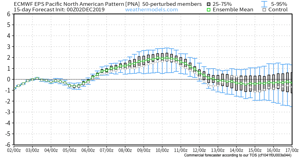
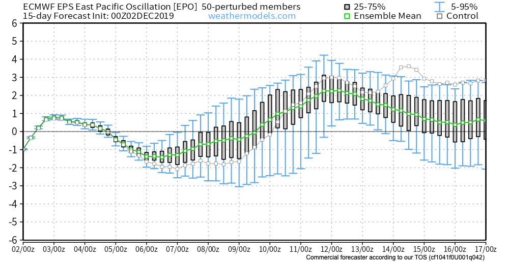
This isn’t to say that we won’t have cold and snow to deal with at times this month. We just believe the colder, wintry conditions that may present themselves will be transitional and that warmth will win out at the end of the day.
As we look ahead, there’s reason to believe other factors will come into play that will begin to change the pattern towards one that’s more suited for prolonged cold around, or just before, Christmas. Furthermore, despite the relative warmth forecast for the month of December, we remain firm on the idea of a colder, snowier than normal winter season.
Permanent link to this article: https://indywx.com/more-december-rumblings-mjo-pna-epo-dont-favor-sustained-cold-yet/
Nov 19
VIDEO: Updated Short Term And Longer Range Thoughts Into Early December…
You must be logged in to view this content. Click Here to become a member of IndyWX.com for full access. Already a member of IndyWx.com All-Access? Log-in here.
Permanent link to this article: https://indywx.com/video-updated-short-term-and-longer-range-thoughts-into-early-december/
Nov 12
VIDEO: Looking Ahead To The Thanksgiving Pattern…
You must be logged in to view this content. Click Here to become a member of IndyWX.com for full access. Already a member of IndyWx.com All-Access? Log-in here.
Permanent link to this article: https://indywx.com/video-looking-ahead-to-the-thanksgiving-pattern/
Nov 05
January-Like Cold Inbound Next Week; What Awaits Thereafter?
“Normals” for January includes highs in the middle 30s and lows in the upper 10s to lower 20s across central Indiana. Early to middle parts of next week are forecast to feature highs in the upper 20s to around 30 and lows in the middle 10s. Yes, these temperatures will challenge records as a truly impressive arctic invasion claims next week’s weather headlines.

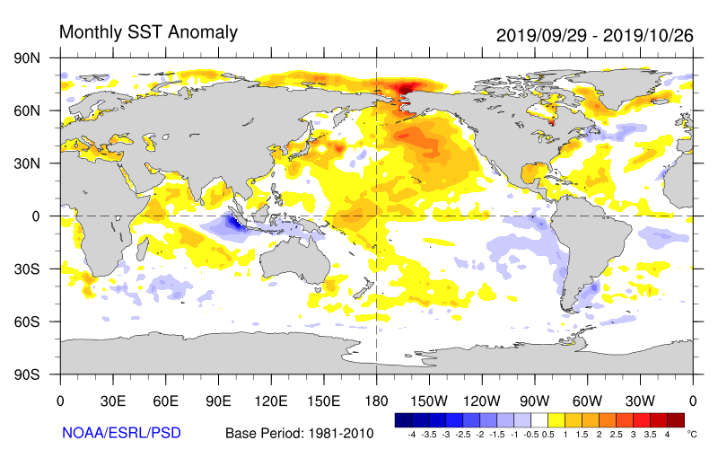
A lot of this has to do with the sea surface temperature (SST) configuration across the northern Pacific. We’ve been focusing in on the warmer anomalies across the north and northeastern Pacific and tendency for this to drive a persistent ridge across NW NA since late summer. That persistent NW NA ridge leads to a persistent trough downstream and the associated cold pattern we’re now looking at. As our Winter Outlook suggests, we think this overall pattern repeats itself throughout the majority of the months ahead.
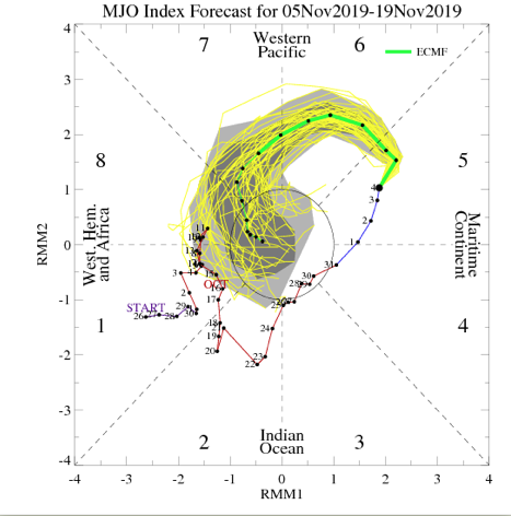
As we look more “immediate term,” what do teleconnections and the MJO tell us about the overall pattern moving past the middle of November? Well, to start, the highly amplified MJO is forecast to roll into Phase 7 around mid-month. This suggests the colder than normal pattern persists.

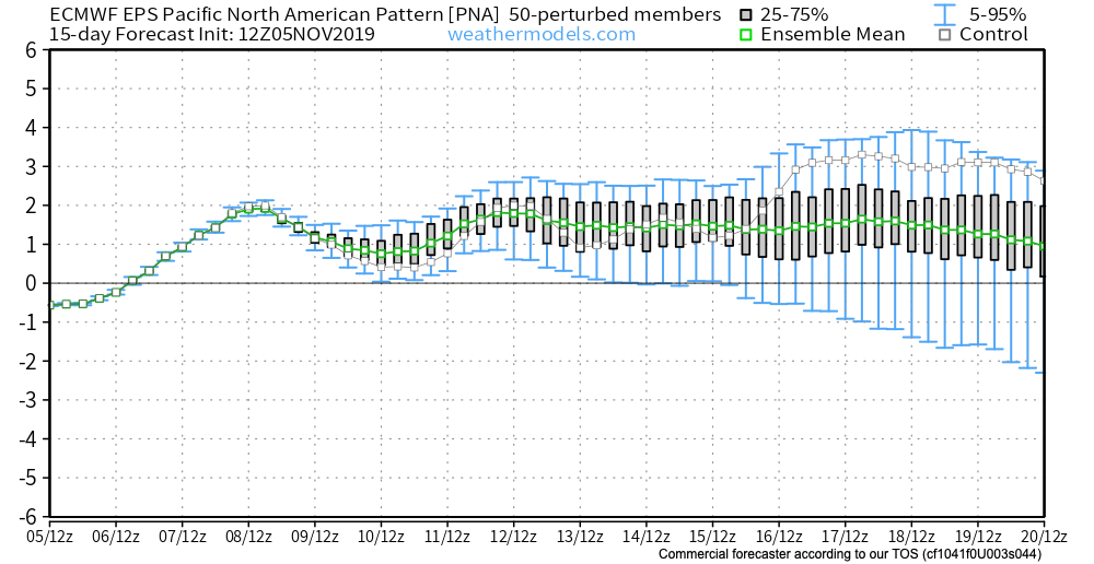
The EPO is forecast to remain negative while the PNA remains positive into and through the mid month period. Both argue for continued cold.

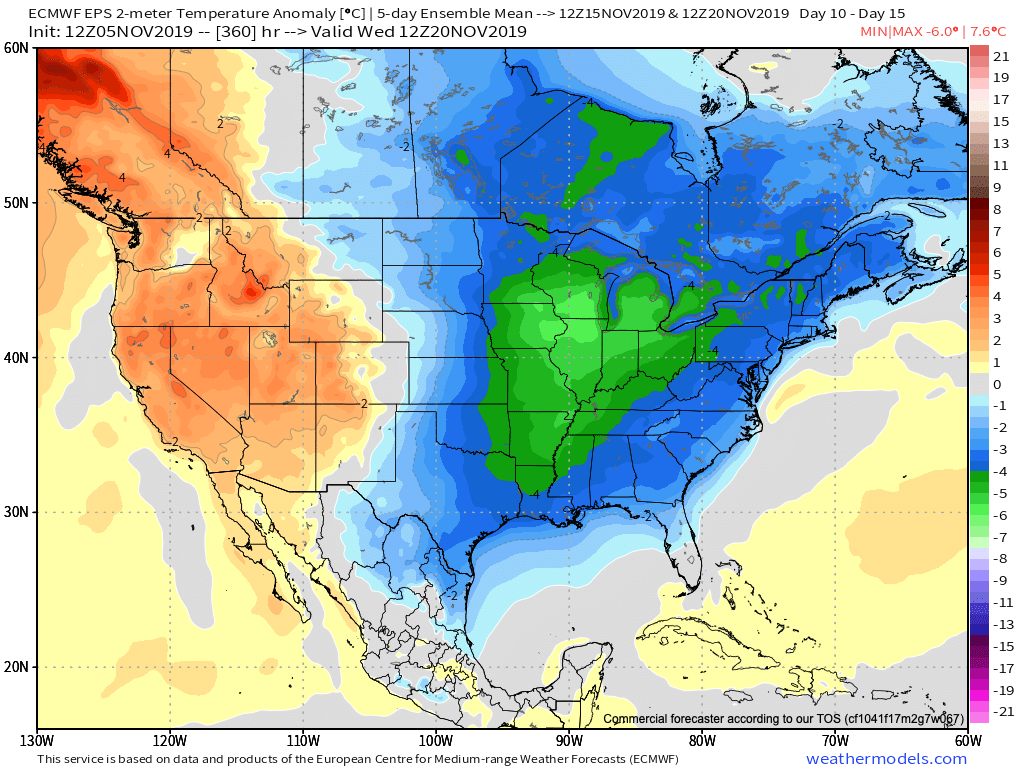
To no surprise, the latest long range data continues to drill unseasonably cold air south into our portion of the country and a large majority of the eastern portion of the Lower 48 in the Weeks 2-3 time period. Snow opportunities will undoubtedly follow with this kind of pattern.
Buckle up…
Permanent link to this article: https://indywx.com/january-like-cold-inbound-next-week-what-awaits-thereafter/
