Window Opening For A Wintry Threat In The 8-10 Day Period?

Updated 01.16.23 @ 11:17a

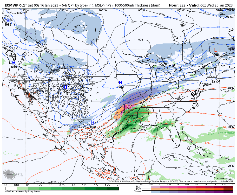
We’ll have a more detailed video discussion posted this evening but wanted to highlight an opportunity for perhaps a more intriguing winter weather setup in the 8-10 day period.

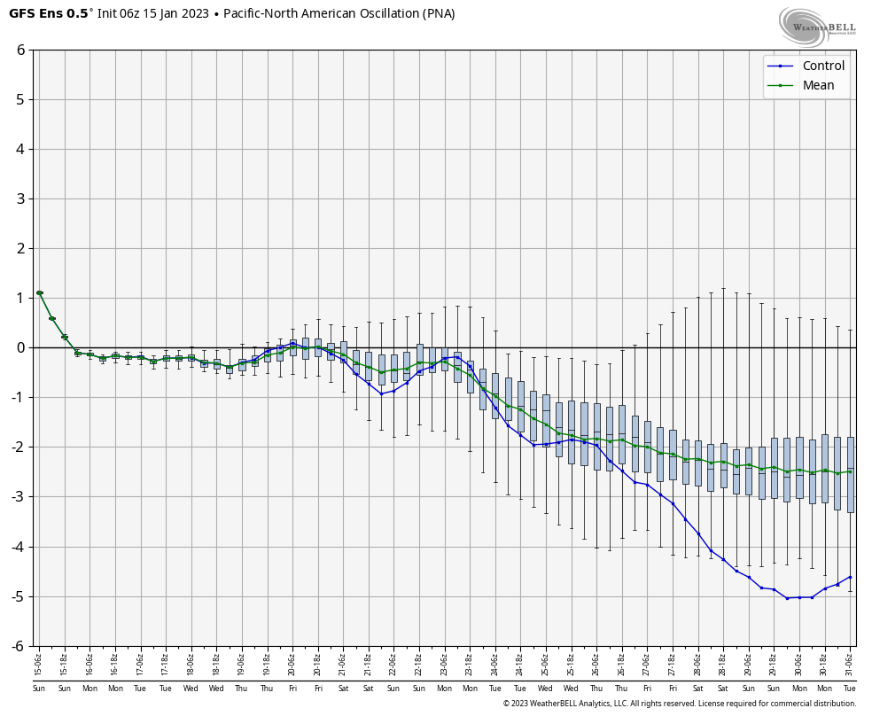
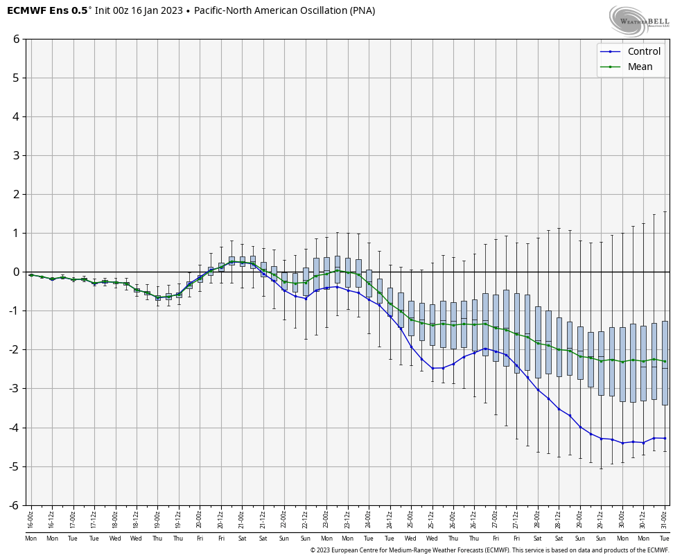
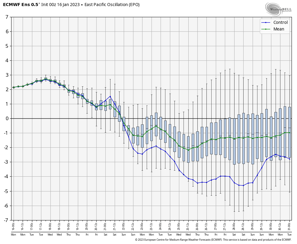
While the time period is too far out for specifics, it does appear as if the pattern will become more favorable for cold and moisture to “marry.” It’s not necessarily a setup for a blockbuster storm, but rather a series of waves of moisture riding northeast along a pressing cold airmass moving southeast. The combination of the PNA (negative) and EPO (negative) means there should be enough resistance from the southeastern ridge to lead to this being more of an Ohio Valley and interior Northeast threat vs “suppression depression.”

For now let’s just circle next weekend into early the following week to see if more of the models begin to catch on to this threat, similar to what the European model is already suggesting perhaps…

More later today!

Active Storm Track; Sustained Cold Tough To Find…

Updated 01.15.23 @ 8:44a

The upcoming 10-day period will feature multiple storms of significance. With a neutral to negative PNA, the storm track should predominantly be on the warm side as the eastern ridge continues to flex its muscle.

“Transitional” cold will follow behind storm systems, but any sort of sustained cold will be mighty hard to come by over the aforementioned period.

A widespread chunk of the country can expect above normal precipitation in this fast paced, overall warm pattern.

Storm dates of interest include 1/16, 1/19, and 1/22-1/23.

Significant Thaw Ahead, But Bullish On Winter’s Return…

Updated 12.26.22 @ 9:40a

It’s certainly no secret that a big thaw is ahead. As we set the bar with this current cold spell, we’ll set the bar for the upcoming period of warmth: minimum of (2) days of highs of 60°, or greater, between Jan. 1 and Jan. 5. It’s another case of a significant thaw following a bitter blast of arctic air. In researching classic arctic outbreaks of the past, this happens many more times than not.

In any event, we continue to see the relatively mild and wet pattern carrying us through the first week of January.

But seeds are already being planted for a renewed wintry spell. In particular, the teleconnections are bullish on cold returning around, or just after, Jan. 10. We note the longer range charts keep these pattern drivers in a favorable position for more of a prolonged period of cold, as well:

Forecasters have to love the overall alignment as this helps build medium to longer range confidence in the overall pattern progression.

Then we add in the MJO rumbling into Phase 7 for early January. While there will be a bit of a lag, this is another signal for a cold look across the eastern portion of the country, especially by that Jan. 10 time frame.

While I can’t say we’ll see another arctic shot to the magnitude of this current frigid regime, I am more confident than normal from this distance in the period that runs from Jan. 10 through Jan. 25 being colder than normal as a whole. I would anticipate the longer range modeling (Weeklies, in particular) becoming increasingly cold with updates this week during that aforementioned period.

More updates to come as we rumble through this holiday week…

VIDEO: Long Range Update And Short-Term Look At Our Next Snow Maker…

Updated 12.23.22 @ 7:58a

You must be logged in to view this content. Click Here to become a member of IndyWX.com for full access.  Already a member of IndyWx.com All-Access?  Log-in here.