Category: NAM Model

Weekly Outlook: Amazingly Cold And Wintry Pattern

November continues to grow increasingly colder than average with each passing day. The prolonged nature of the severe cold is astounding for early and mid November. Average low temperatures this…

You must be logged in to view this content. Click Here to become a member of IndyWX.com for full access.  Already a member of IndyWx.com All-Access?  Log-in here.

Permanent link to this article: https://indywx.com/2014/11/17/weekly-outlook-amazingly-cold-and-wintry-pattern/

50/50 Split On Sunday Night Snow…

Quick-hitting Bullet Points:

  • Light snow Saturday night
  • Still questions around Sunday night snow potential
  • Even colder air invades early next week
  • Fun and games continue in the longer range

The afternoon model suite is in in it’s entirety and it leaves us with about as many questions as answers :-)…

Four of our more trusted short-term forecast models are split 50/50 on the outcome Sunday night.  In the snowy camp you have the NAM and European.  In the drier camp you have the GFS and GEM.  Past experience with this type event says the European and NAM solutions may have the better handle and we think the drier modeling will shift a touch northwest with time over the upcoming 24 hours.  The difference between camps would be a nice 2-3″ type snowfall for the Monday morning commute across central Indiana versus nothing more than a few flurries.  More as the details become clearer…

We still forecast light snow to overspread central Indiana Saturday evening and night.  While this won’t be a big deal, a dusting to 1″ of snow is a good bet across most of central Indiana, especially from the I-70 corridor and points north.  Roads may be slick in spots on your way to church Sunday morning.

One thing that’s a certainty is that another blast of arctic air will invade along with scattered snow showers early next week.  This push of bitter air will be even colder than this weeks.

In the longer term, plenty of wintry “fun and games” remain.  In fact, today’s 12z European has the look set to offer more meteorological headaches come late next week.  Ah, the season is only beginning… 🙂

f168

Permanent link to this article: https://indywx.com/2014/11/14/5050-split-on-sunday-night-snow/

Cool Autumn Weekend; Severe Storm Potential Monday Night…

Sat.

Sun.

Mon.

Tue.

Wed.

Thr.

Fri.

 Status-weather-clouds-icon

 Status-weather-showers-day-icon

 Status-weather-storm-night-icon

 Status-weather-showers-scattered-icon

 Status-weather-clouds-icon

 Status-weather-clouds-icon

 Status-weather-clouds-icon

– –/ 59

42/ 62

56/ 73

55/ 67

52/ 63

51/ 60

50/ 69 

Cool Autumn Weekend…The rest of today will feature mid and high level cloudiness, but dry conditions.  Cool north to northeast winds will blow and require jackets or sweaters if venturing outside for too long of a time.

Be sure to enjoy the brief dry weather Saturday as shower chances return as early as Sunday, particularly during the afternoon hours and on.  Moisture will begin to surge back north in advance of a storm system that will lead to some rough weather around these parts to open the new work week.

Monday Severe Potential…Gusty southwest winds will usher in a warmer and more humid feel of things Monday out ahead of our next strong storm system.  We continue to closely monitor the potential of severe weather Monday night into Tuesday morning and want to highlight the threat of damaging straight line wind potential embedded with a possible squall line.  Beforehand, showers and embedded thunder will be possible during the daytime Monday.

We note the GFS remains consistent on strong to severe storm potential Monday night into Tuesday morning while the European is more delayed (suggesting more of a threat during the day time Tuesday).  For now, we’re leaning more towards the GFS and we’ll have more on the early week severe threat Sunday.  Locally heavy rain is also a good bet during this time, including widespread 1″-1.5″, with locally heavier totals.

Taking The More Optimistic Approach…Some forecast data wants to keep considerable cloudiness and pesky light showers around into the mid week period, but for now we’re still going with the more optimistic outlook and including drier weather along with cooler temperatures for the balance of the upcoming work week.

Upcoming 7-Day Precipitation Forecast:

  • 7-Day Rainfall Forecast: 1-2″
  • 7-Day Snowfall Forecast: 0.00″
hires_ref_ky_61

We continue to highlight Monday night/ Tuesday morning for the potential of severe weather, including damaging straight line winds. Here’s what the high resolution NAM simulated radar suggests at 8p Monday local time.


Permanent link to this article: https://indywx.com/2014/10/11/cool-autumn-weekend-severe-storm-potential-monday-night/

Stormy/ Rainy Wednesday Shaping Up…

The Storm Prediction Center continues to outline our region for severe potential Wednesday. Early indications suggest we’re eyeing another evening and nighttime storm threat, but there remain questions in regards…

You must be logged in to view this content. Click Here to become a member of IndyWX.com for full access.  Already a member of IndyWx.com All-Access?  Log-in here.

Permanent link to this article: https://indywx.com/2014/09/08/stormy-rainy-wednesday-shaping-up/

IndySportsReport.com Football Forecast Highlights Nighttime Storms…

Good morning football fans (best time of year, IMO)!  Your IndySportsReport.com High School Football Forecast features one more warm and humid evening highlighted by an increasingly stormy look as the evening transitions into the nighttime hours.

A cold front will slice into a very warm and humid air mass Friday night.  After a mostly quiet weather day across central Indiana, conditions will begin to go downhill Friday evening and night as the front draws closer.  We’ll monitor a line of thunderstorms approaching the region later tonight and a few of these could be strong to severe.  This shouldn’t be a major severe weather episode, but it only takes one strong to severe storm to make a mess of things.

We'll target 7p to midnight for a line of strong to potentially severe storms to move through central Indiana. Folks attending high school football games should monitor radar and weather conditions.

We’ll target 7p to midnight for a line of strong to potentially severe storms to move through central Indiana. Folks attending high school football games should monitor radar and weather conditions.

Dew points will be oppressive (in the lower 70s) and lead to a muggy feel.  Precipitable water values will reach 2″ in spots and suggest a locally heavy rainfall threat within the stronger storms.

hires_pwat_indy_34

Official IndySportsReport.com high school football forecast for Friday, Sept 5th:

Increasingly cloudy, warm, and humid.  Coverage of showers and thunderstorms will increase from north to south through the evening and nighttime hours.  A few of the storms may become strong to severe and produce vivid cloud-to-ground lightning, locally heavy rain, and strong winds.  Rainfall potential tonight will range from 0.25″ to 0.50″, but some local downpours may push totals closer to 1″ in localized spots.  Temperatures will begin in the mid to upper 80s before slowly falling through the game.

Permanent link to this article: https://indywx.com/2014/09/05/indysportsreport-com-football-forecast-highlights-nighttime-storms/

Storms And Heat…

Good morning and happy Thursday! This will be a quick post this morning before a more extensive update and 7-day outlook later this evening. The SPC highlights our region for…

You must be logged in to view this content. Click Here to become a member of IndyWX.com for full access.  Already a member of IndyWx.com All-Access?  Log-in here.

Permanent link to this article: https://indywx.com/2014/08/21/storms-and-heat/

Wednesday Morning Rambles…

The combination of passing storms and the setting sun Tuesday evening provided sun incredible rainbows. Thanks to John Feister for sharing this photo taken near Whitestown. John Salewicz snapped this…

You must be logged in to view this content. Click Here to become a member of IndyWX.com for full access.  Already a member of IndyWx.com All-Access?  Log-in here.

Permanent link to this article: https://indywx.com/2014/08/20/wednesday-morning-rambles-2/

Severe Weather Threat Tuesday

Tonight’s video update highlights:

  • Tuesday severe threat
  • Big-time weekend heat
  • Cooler pattern to wrap up August

The Storm Prediction Center has outlined a risk of severe weather Tuesday across the state.

The Storm Prediction Center has outlined a risk of severe weather Tuesday across the state.

Permanent link to this article: https://indywx.com/2014/08/18/severe-weather-threat-tuesday/

Throw An Extra Blanket On The Bed Tonight…

Thr.

Fri.

Sat.

Sun.

Mon.

Tue.

Wed.

 Status-weather-clouds-icon

 Status-weather-clouds-icon

 Status-weather-showers-day-icon

 Status-weather-showers-day-icon

 Status-weather-showers-day-icon

 Status-weather-showers-day-icon

 Status-weather-showers-day-icon

55/ 78

48/ 76

56/ 81

64/ 83

69/ 81

70/ 81

67/ 85 

Reinforcing Cool Air Blowing In…A reinforcing push of cool air is blowing into town today and will result in a downright chilly night ahead (especially considering the time of year).  A couple showers can still be expected across south-central parts of the state, but won’t amount to much.  The big news will be the chilly temperatures tonight as we forecast upper 40s officially in the city and low to mid 40s across northeastern suburbs.  Highs will only climb into the middle 70s with lots of sunshine Friday.

Warmer And More Unsettled…Temperatures will moderate into the weekend, but we’re also going to introduce rain chances back into the picture.  Most of Saturday will remain rain-free, but we can’t rule out scattered showers and thunderstorms as the first in a series of disturbances tries to overcome initial dry air in place.  Better rain and storm chances will prevail Sunday.

Heavy Rain Next Week…Forecast rainfall numbers continue to rise next week as a series of weather makers impacts central Indiana.  A good consensus would place 1.5″ to 2″ of rain down, with locally heavier totals.  Stay tuned as we fine tune timing.

7-Day Precipitation Outlook:

  • 7-Day Rainfall Forecast: 1.5″-2″
  • 7-Day Snowfall Forecast: 0.00″

We’re enjoying another colorful sunrise across central Indiana this morning.  John Salewicz snapped this scenic photo earlier this morning.  Thanks, John!

en9WWAwc

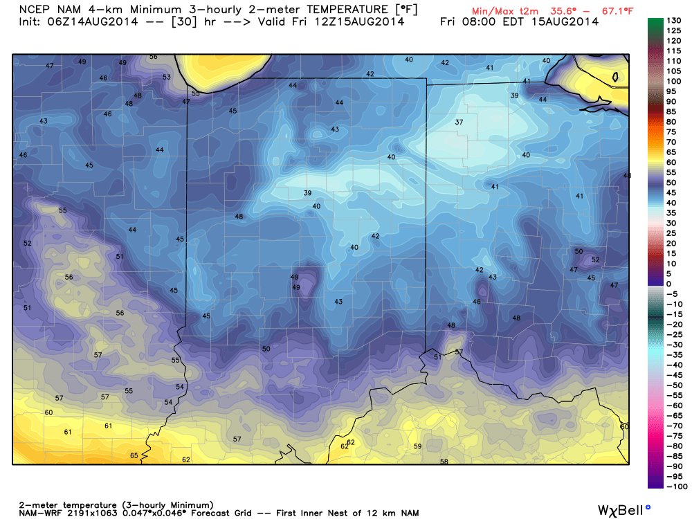
Throw an extra blanket on the bed tonight!  Temperatures will dip into the mid to upper 40s for many.

Throw an extra blanket on the bed tonight! Temperatures will dip into the mid to upper 40s for many.

Permanent link to this article: https://indywx.com/2014/08/14/throw-an-extra-blanket-on-the-bed-tonight/

Unsettled Couple Days Ahead Before A Taste Of Fall By Mid Week…

Scattered to numerous showers and thunderstorms continue to impact central Indiana, along with localized flash flooding (precipitable water values are currently above 2″ in spots and suggest localized very heavy…

You must be logged in to view this content. Click Here to become a member of IndyWX.com for full access.  Already a member of IndyWx.com All-Access?  Log-in here.

Permanent link to this article: https://indywx.com/2014/08/10/unsettled-couple-days-ahead-before-a-taste-of-fall-by-mid-week/

IndyWx.com