Updated 05.12.22 @ 9:42p
You must be logged in to view this content. Click Here to become a member of IndyWX.com for full access. Already a member of IndyWx.com All-Access? Log-in here.

May 12
Updated 05.12.22 @ 9:42p
You must be logged in to view this content. Click Here to become a member of IndyWX.com for full access. Already a member of IndyWx.com All-Access? Log-in here.
Permanent link to this article: https://indywx.com/video-looking-at-the-pattern-into-memorial-day-weekend-and-early-june/
May 10
Updated 05.10.22 @ 6:30a
There’s a reason we labeled the midweek pattern as a “taste” of summer. Thankfully, (speaking for most, I believe) we’re not ready to “lock and load” the summer like heat and humidity. In fact, we’ll get some relief from humidity by the latter stages of the work week. By early next week, highs will drop back into the lower 70s and overnight lows will fall into the 40s.

Despite the roller coaster ride the next couple of weeks will likely deliver from a temperature perspective (remember, we have the MJO to deal with again now, too), the pattern, as a whole, looks drier than normal over the upcoming 10-14 days.

While the pattern is likely one to continue featuring wild swings in temperatures to wrap up the month, most of the frontal systems seem like they won’t deliver excessive rainfall amounts from this distance. It should be noted the European data above has plenty of support from its American and Canadian counterparts.
Permanent link to this article: https://indywx.com/transitional-is-the-theme-for-our-temperature-pattern-upcoming-10-14-days-precipitation-pattern-not-so-much/
May 08
Updated 05.08.22 @ 12:30p
You must be logged in to view this content. Click Here to become a member of IndyWX.com for full access. Already a member of IndyWx.com All-Access? Log-in here.
Permanent link to this article: https://indywx.com/video-warming-up-and-turning-quite-humid-overall-quiet-until-next-weekend/
Apr 22
Updated 04.22.22 @ 7:50a
You must be logged in to view this content. Click Here to become a member of IndyWX.com for full access. Already a member of IndyWx.com All-Access? Log-in here.
Permanent link to this article: https://indywx.com/video-gorgeous-weekend-long-range-update-into-mid-may/
Apr 14
Updated 04.14.22 @ 5:23p
While we should see a period of significant moderation in the 8-10 day period, yet again, this is likely to only be a 2-4 day, transitional spike. This is likely a byproduct of the lag effect of a positive NAO (North Atlantic Oscillation), but notice what happens longer term: a moderately negative NAO returns as we go into next weekend and beyond.
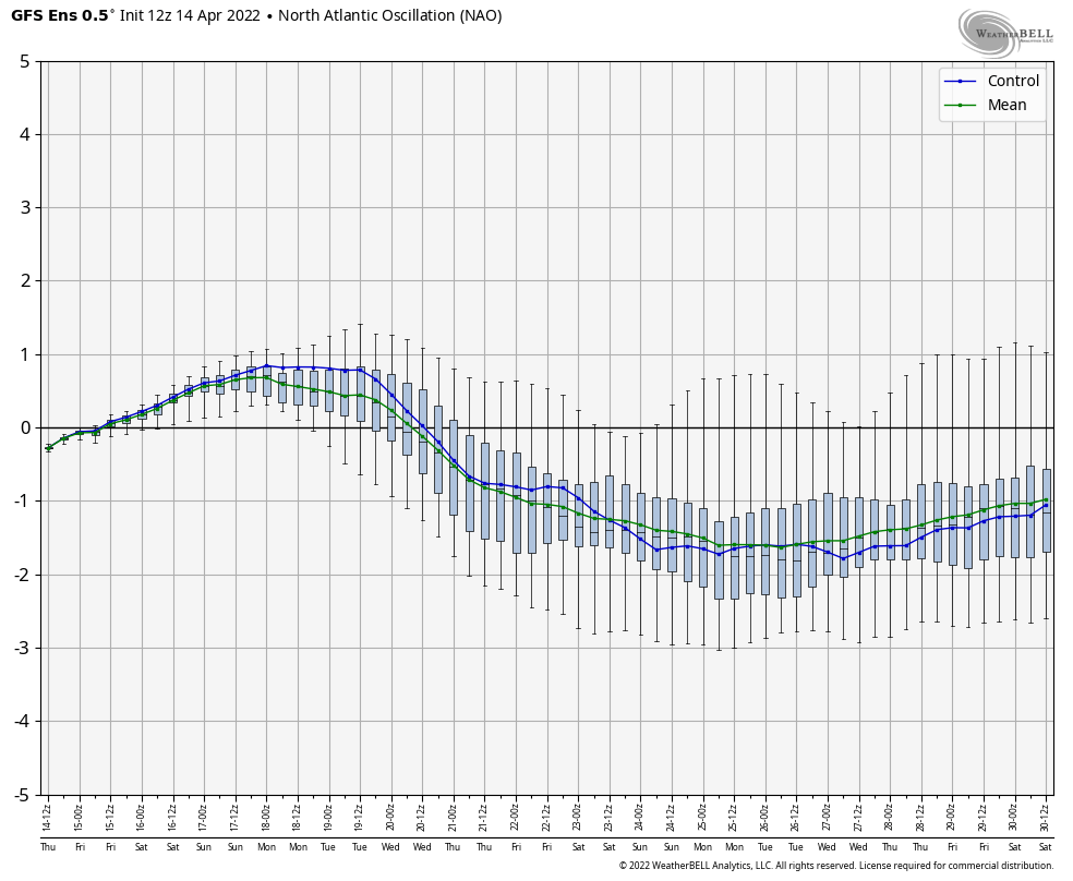
The transitional warm-up that will show itself next weekend and into early Week 2 will likely take a back seat to a renewed chilly (by late April standards) time of things before we close out the month. Ensemble guidance is picking up on this.
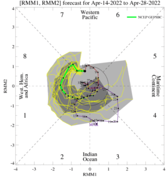
Then you add in the expected MJO movement over the next couple of weeks. Guidance shows us moving into Phase 1 late month. This is a phase in April that loves to drive more of a tendency for a trough over the East.
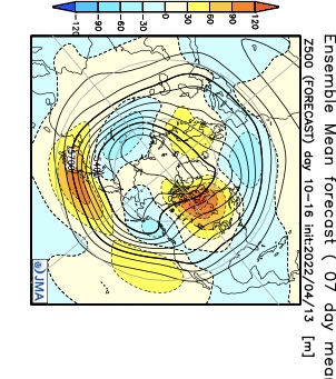
Longer range models, including the JMA and CFSv2 Weeklies, show the cooler look to wrap up the month, relative to normal. Given the alignment between the NAO and MJO, it’s hard to argue with this idea.

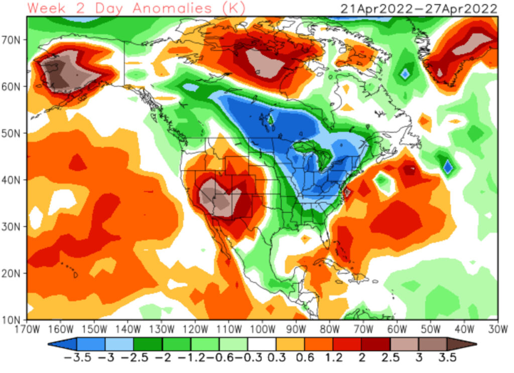
There will be more frequent opportunities for late season frost compared to normal as we wrap up April. Precipitation over the next couple of weeks should balance out close to average as a whole.
Permanent link to this article: https://indywx.com/long-range-discussion-never-trust-a-sustained-warm-up-with-a-negative-nao-this-time-of-year/