VIDEO: Light Wintry Precipitation Across The Central, Southern Portion Of The State; Longer Range Pattern Update…

Updated 01.29.23 @ 5:35p

You must be logged in to view this content. Click Here to become a member of IndyWX.com for full access.  Already a member of IndyWx.com All-Access?  Log-in here.

February And Early March Long Range Discussion…

Updated 01.19.23 @ 6:15p

Our short-term products will continue to handle the snow threats this weekend and next week. In short, we have no changes to our thoughts on either of those from this morning. The 2nd storm has potential to be something much more significant, but we need to give it another 2-3 days before putting a forecast in concrete, especially this winter.

As for the longer range, a more seasonably cold brand of air is expected as we put a wrap on January, but I’m not willing to go further than that to suggest anything close to “bitter” cold is on deck- certainly given the time of the year. It’ll feel much colder, especially considering just how warm it’s been of late, but I just don’t see anything overly cold on the horizon, compared to normal.

Thereafter, the pattern drivers suggest a warmer than normal pattern will return. “Transitional” anyone? While I can’t say we’re looking at anomalies as great as what we’ve seen so far in January, I do think early and mid February will feature above to well above normal temperatures before colder than normal trends take hold late February and into early March.

The updated European Weeklies mirror the new JMA Weeklies and we see no reason to argue given the movement and overall alignment between the EPO, PNA, NAO, and AO.

Week 2

JMA Weeks 3/4

European Weeklies: Week 3


European Weeklies: Week 4


As we get out towards the latter part of February (around or after the 20th), the teleconnections mentioned above, that will likely promote the relatively warm conditions, will begin to turn around and drive a colder close to the month and open to March. In fact, there are signs the coldest anomalies of the entire winter (compared to average, not in the “absolute” form) will await for this period, and potentially continue into a good chunk of March, especially if the MJO amplitude continues and we add in a negative NAO. (I know, I know- remember that I’m only the messenger).

In the meantime, we also agree with the above normal precipitation pattern painted throughout the upcoming few weeks between the updated Weekly products.

In this active type pattern, despite the lack of bitterly cold arctic air, plenty of snow is likely still yet to fall this winter. In fact, despite the slow start, I wouldn’t be shocked if snowfall amounts end up being pretty dang close to seasonal averages with this type pattern (give or take a few inches). The ultimate irony will be if the bulk of that falls in March…

Much more in the morning around the Sunday and Tuesday-Wednesday snow threats!

VIDEO: Parade Of Storms Lined Up; Updated Long Range Discussion…

Updated 01.12.23 @ 7:55a

You must be logged in to view this content. Click Here to become a member of IndyWX.com for full access.  Already a member of IndyWx.com All-Access?  Log-in here.

Continuing To Monitor The Weak Weekend System; Any Way Out Of The Warm Pattern?

Updated 01.07.23 @ 5a

The short answer, of course, to this morning’s headline is a resounding “YES,” but it’s going to take some work. We have a weak weather maker in our neck of the woods this weekend (this pesky system could still generate some light wintry accumulation across portions of the region Sunday afternoon and evening, but timing is going to have to be just right for anything overly “exciting” to occur) and another system to track the middle and latter part of next week, but the reality of the immediate term is that unseasonably warm and unseasonably quiet conditions will prevail for the better part of the upcoming 7-10 days. With that, we wanted to take some additional time to look ahead.

Before we dive into the future, let’s take a look back at how temperatures compared against the norm over the past several weeks.

Past 45 days: ending Jan 1

Past 30 days: ending Jan. 1

For all the headlines the warmth to open January has provided (rightfully so, I might add), the reality of the situation is the better part of the past month and a half has run slightly colder than normal for our neck of the woods, and a good chunk of the Lower 48 as a whole. The lack of snow and glaring missed opportunity to “cash in” just before Christmas with something more meaningful on the winter weather front has understandably led to a bad taste as we’ve opened up the ’22 – ’23 winter for some.

While the upcoming 10 days doesn’t offer up much in the way of hope for winter weather lovers, we wanted to take an opportunity to look forward to the latter part of January.

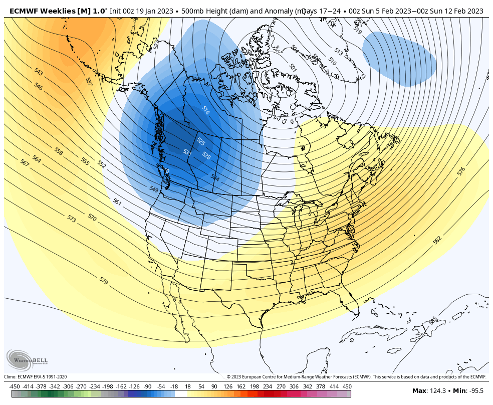
As we’ve been posting, the East Pacific Oscillation (EPO) is putting a big wrench in the favorable movement of the Madden-Julian Oscillation (MJO). In fact, the EPO is forecast to move into an even stronger positive phase over the next week. This will likely drive continued well above normal temperatures, as a whole, through mid-January. However, we do note the longer range guidance shifts the EPO slightly negative just after mid-January, continuing into early February. It’s encouraging to see the GFS extended and European extended products showing this EPO transition and the overall agreement. Of course, we also saw that same negative trend modeled for right now and that was a tremendous miss on both model’s part, so some caution is recommended from this distance.

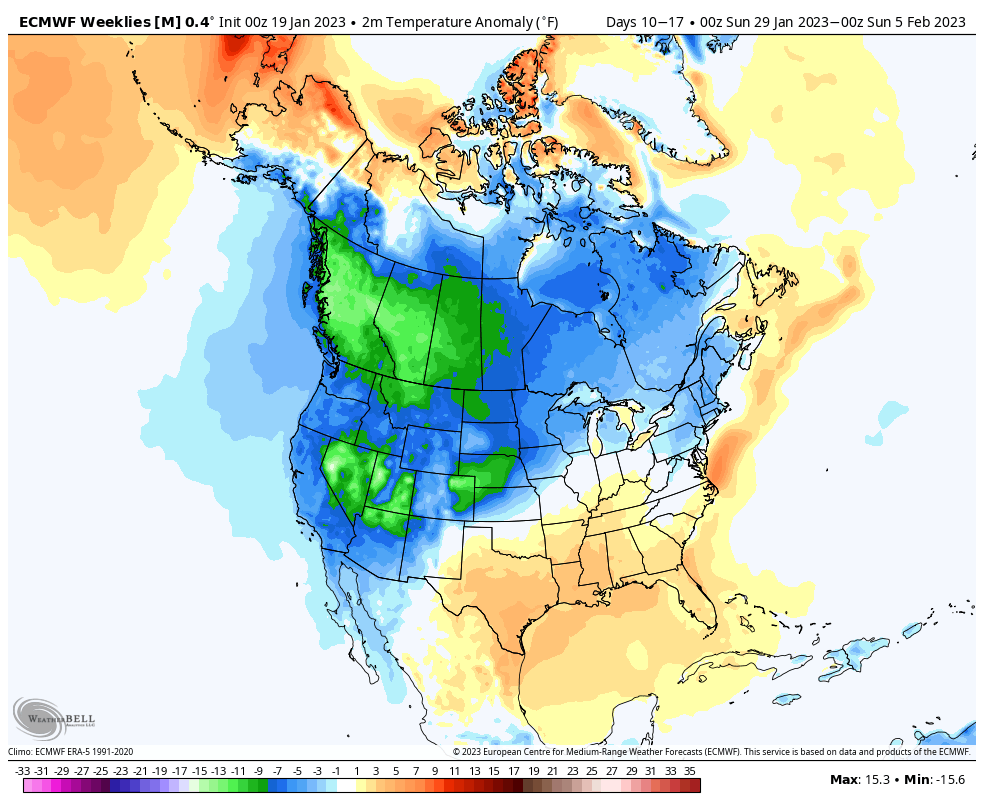
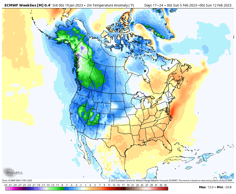
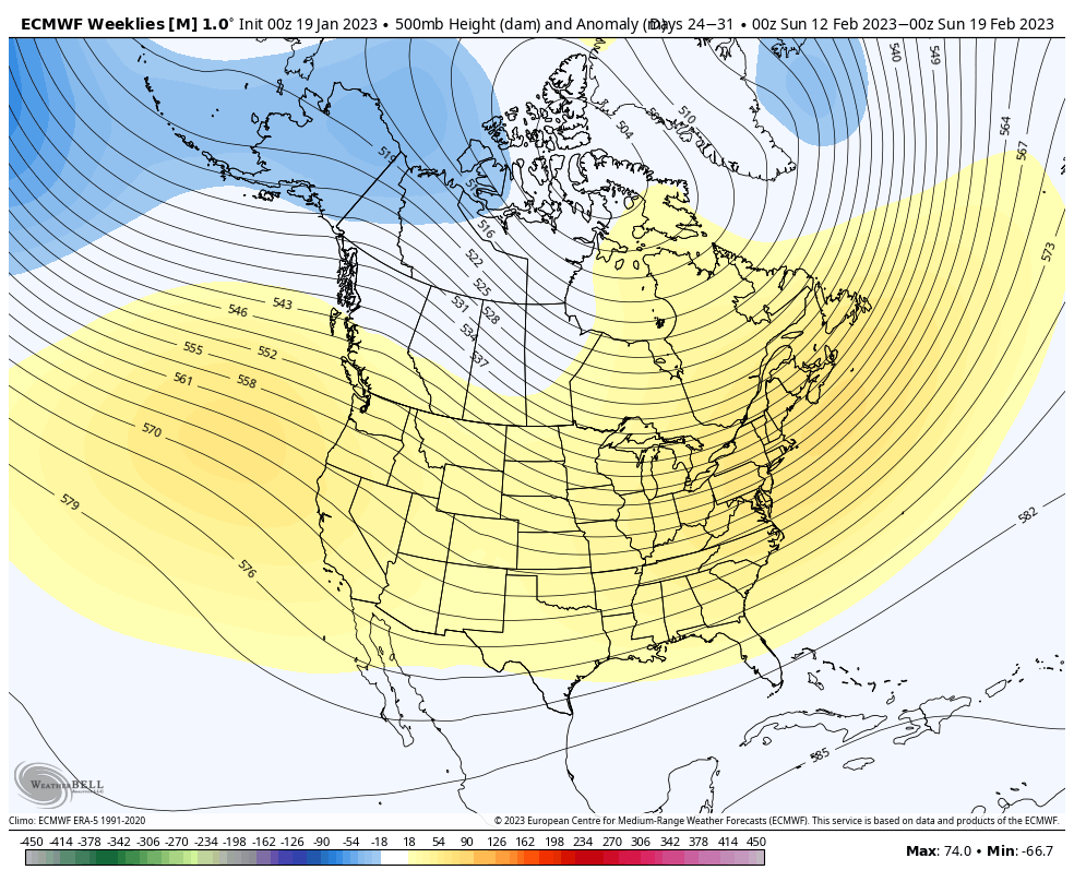
With that said, we do note the European Weeklies (updated version as of Thursday evening) trending significantly colder in the late January and early February period.

Should the EPO finally, indeed, go negative, you combine that with an MJO that will likely still be in a favorable phase for cold, then it’s easy to understand how this pattern can flip rather quickly.

On the precipitation front, while the next week to 10 days will be quite unlike a traditional Nina pattern, the regime should become more active during the 2nd half of the month, including a busy storm track through the Ohio Valley region.

Much more later- enjoy your weekend!