Updated 11.15.22 @ 7:43a
You must be logged in to view this content. Click Here to become a member of IndyWX.com for full access. Already a member of IndyWx.com All-Access? Log-in here.

Nov 15
Updated 11.15.22 @ 7:43a
You must be logged in to view this content. Click Here to become a member of IndyWX.com for full access. Already a member of IndyWx.com All-Access? Log-in here.
Permanent link to this article: https://indywx.com/video-short-term-snow-update-pattern-drivers-that-should-dominate-the-bulk-of-this-years-holiday-season/
Nov 10
Updated 11.10.22 @ 9:18a
After a warm open to November, things are progressing to plan as our much anticipated mid month shift to cold takes place.
A quick glance at the teleconnections over the course of the next couple weeks (remember, we still lean heaviest on the PNA and EPO at this time of the year) reveals agreement in the short term of the cold shift but note movement back towards neutral towards the end of the period.

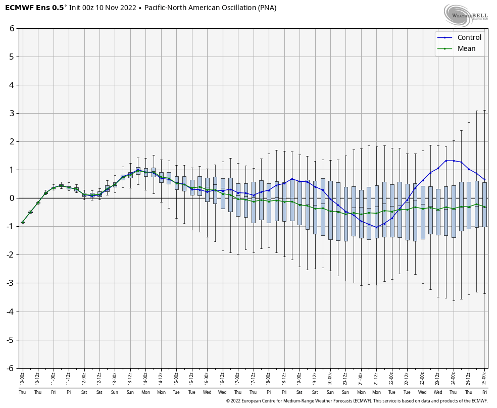
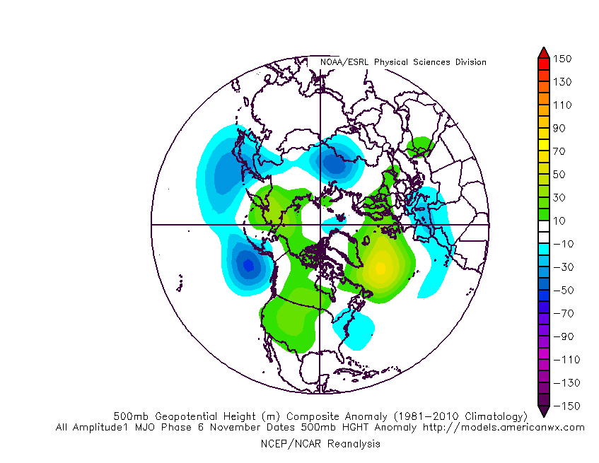
While this may give reason for panic to some, we note the MJO scheduled to move out of Phase 8 (currently), whip across the “null” phase before moving into textbook phases for eastern cold for late November (Phases 5-6).

The analogs for such phases this time of year will make winter weather fans salivate.

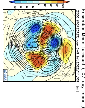
Despite this setup laid out above, the new JMA Weeklies want none of my idea of a cold start to December. Despite the chilly look Weeks 1-2, the model rolls right into an eastern ridge by early December. It’s safe to say as of now, I remain in the cold camp, especially given what the MJO amplitude should provide as we rumble into the last month of the year. Nonetheless, it’s less than ideal to see a normally trusted model in such disagreement and we’ll have to keep an eye on trends over the course of the next couple weeks…

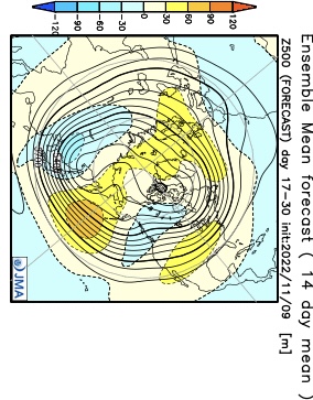
Perhaps the model is seeing a transitional move through Phase 7? That would allow a milder pattern in briefly, but again I would reiterate the look of what should be an amplified MJO as we move into December and a jaunt through Phase 8, 1, and 2 is likely in my opinion. Just for fun, this is what those phases provide.

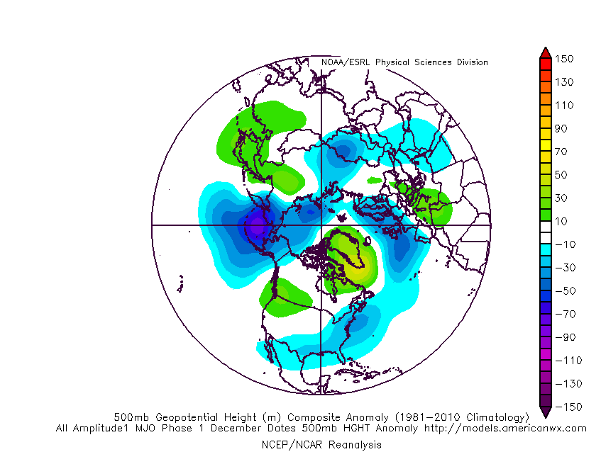
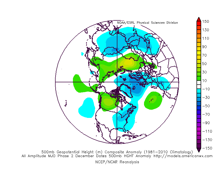
One way or another, we have a lot of work (and fun) ahead. My hunch tells me any long range (what would currently be Week 4 in particular) data will be forced to cool, and perhaps significantly so, as time draws closer.
In the meantime, don’t sleep on next week. There should be at least one attempt for some sort of winter weather maker into the Ohio Valley, if not two.
Permanent link to this article: https://indywx.com/long-range-outlook-jab-jab-boom/
Nov 06
Updated 11.06.22 @ 10:47a
“Wintry” is certainly not a word that comes to mind when describing the first week of November ‘22. Indianapolis is running a whopping 11.4° above normal month to date.

The upcoming several days will feature additional well above normal warmth, including highs in the mid 60s to around 70°. The reasons behind the warmth have been well advertised between the MJO and teleconnections. This is all part and parcel to the SST configuration, including the 3rd consecutive La Niña fall.
But things are changing now and arriving right on schedule. It’s wild, really, when you think of the ability to find answers to the future (upcoming pattern evolution) by looking back at the past.
We note the teleconnections are now beginning to align in a manner that will drive colder than normal conditions east. The MJO also has a look that will try and circle back into Phase 6 mid to late month. To add to the complexity of the pattern transition, a late season hurricane will likely hit the Florida peninsula mid to late week before recurving up the eastern seaboard.
A cold front will blow through the state Friday and while it’ll likely be moisture starved, unlike this past front, there will be a sharp temperature drop behind the frontal passage over the weekend.

How about a week from today highs are only in the mid-upper 30s and lows may dip into the upper 10s and lower 20s. Indications are that the overall colder than normal regime will have staying power, too. While wholesale pattern transitions can be finicky at the onset, there’s a belief on this front that the overall regime will feature more sustainable cold and eventually opportunities for wintry precipitation as we close November and open up December.
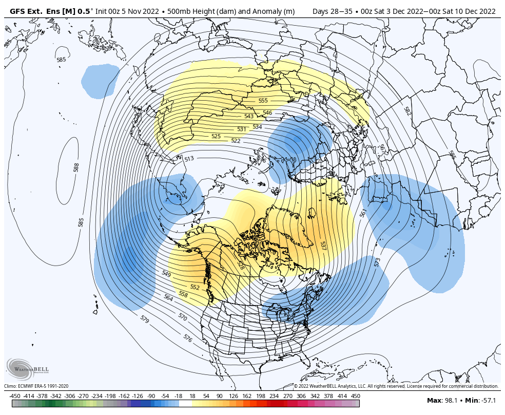
There’s no change to the ideas here of the bulk of the holiday season this year (Thanksgiving to New Years) providing above normal snowfall and below normal temperatures. At the very least, there should be a lot of “fun and games” ahead over the upcoming weeks.
Permanent link to this article: https://indywx.com/the-transition-to-winter/
Oct 30
Updated 10.30.22 @ 9:58a Timing isn’t on our side as chances of rain will continue for the all important trick or treat hours. More on this and a look ahead…
You must be logged in to view this content. Click Here to become a member of IndyWX.com for full access. Already a member of IndyWx.com All-Access? Log-in here.
Permanent link to this article: https://indywx.com/video-unsettled-weather-continues-for-the-all-important-trick-or-treat-hours-quiet-and-warm-conditions-return-as-we-open-november/
Oct 20
Updated 10.20.22 @ 5:48p
It’s been a chilly October. Officially, IND is running more than 4° below average month-to-date. It’s also been dry. We’re running close to 2″ below normal in the rainfall department.
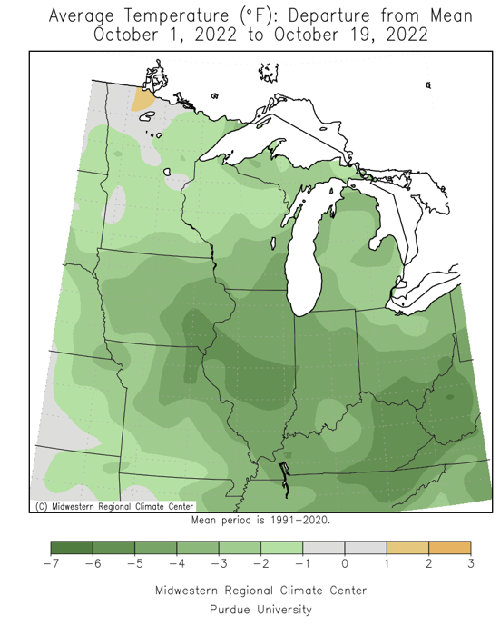
When we look at the pattern drivers, it’s hard to see a way for there to be any sort of prolonged chill (compared to normal) over the next couple of weeks. That’s not to say there won’t be “pops” of cooler air here and there, but given the EPO and PNA state below, the upper pattern should favor more persistent ridging across the eastern portion of the country as opposed to the troughiness of late.


The MJO (likely a major driver this upcoming winter) is forecast to move out of Phase 6 into Phase 7 late October.
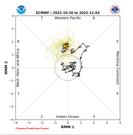
Phase 7 favors a western trough and associated cooler temperatures compared to average across the western portion of the country.

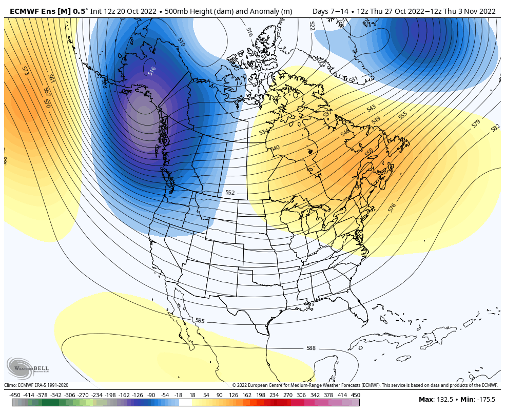
To no surprise, modeling sees the ‘mean’ trough and ridge placement in exact positions that we’d expect given the primary pattern drivers laid out above.
Week 1 500mb
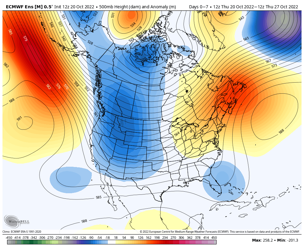
Week 2 500mb
It’s also a continued overall drier than normal pattern, locally, over the next couple of weeks (in the face of a midweek storm system that should at least provide some unsettled weather the middle of next week- more on this in our short-term products).

As we look ahead towards November, there are potential changes with respect to the primary pattern drivers that could shift a colder regime back east. Note we think the month opens warmer than normal, but that things begin to take a turn towards the colder towards mid-month. Interestingly, the longer range teleconnection forecasts see the EPO heading negative by mid-Nov and the PNA heading neutral to positive. These are encouraging signs our idea is on the right path and perhaps that a colder pattern emerges during the lead-up to the holidays this year.
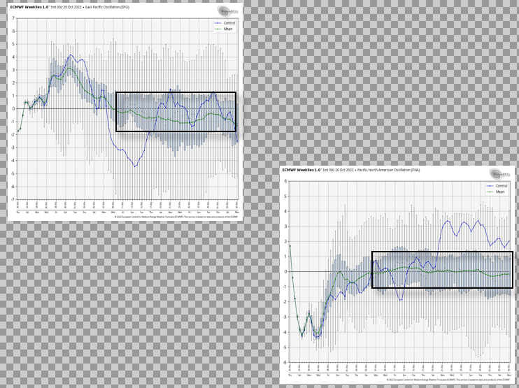
The NEW European Weeklies develop a 500mb look that features plenty of high latitude blocking by mid-November and should this be correct (we think it is), we should see the model trend colder across the East during this time period. Needless to say, this is the period we’ll continue to keep close tabs on…

Permanent link to this article: https://indywx.com/lr-update-late-october-into-mid-november-pattern-progression/