You must be logged in to view this content. Click Here to become a member of IndyWX.com for full access. Already a member of IndyWx.com All-Access? Log-in here.
Category: Long Range Discussion
Permanent link to this article: https://indywx.com/video-looking-ahead-into-mid-late-next-week-reviewing-new-jma-weeklies-into-august/
Jul 09
Long Range Update Into Early August…
You must be logged in to view this content. Click Here to become a member of IndyWX.com for full access. Already a member of IndyWx.com All-Access? Log-in here.
Permanent link to this article: https://indywx.com/long-range-update-into-early-august/
Jul 08
Afternoon Video: Short-Term Update Discussing Weekend Storm Chances And Looking At The Pattern To Close July…
You must be logged in to view this content. Click Here to become a member of IndyWX.com for full access. Already a member of IndyWx.com All-Access? Log-in here.
Permanent link to this article: https://indywx.com/afternoon-video-short-term-update-discussing-weekend-storm-chances-and-looking-at-the-pattern-to-close-july/
Jul 07
July To-Date And Where We Think We’re Going The Rest Of The Month…
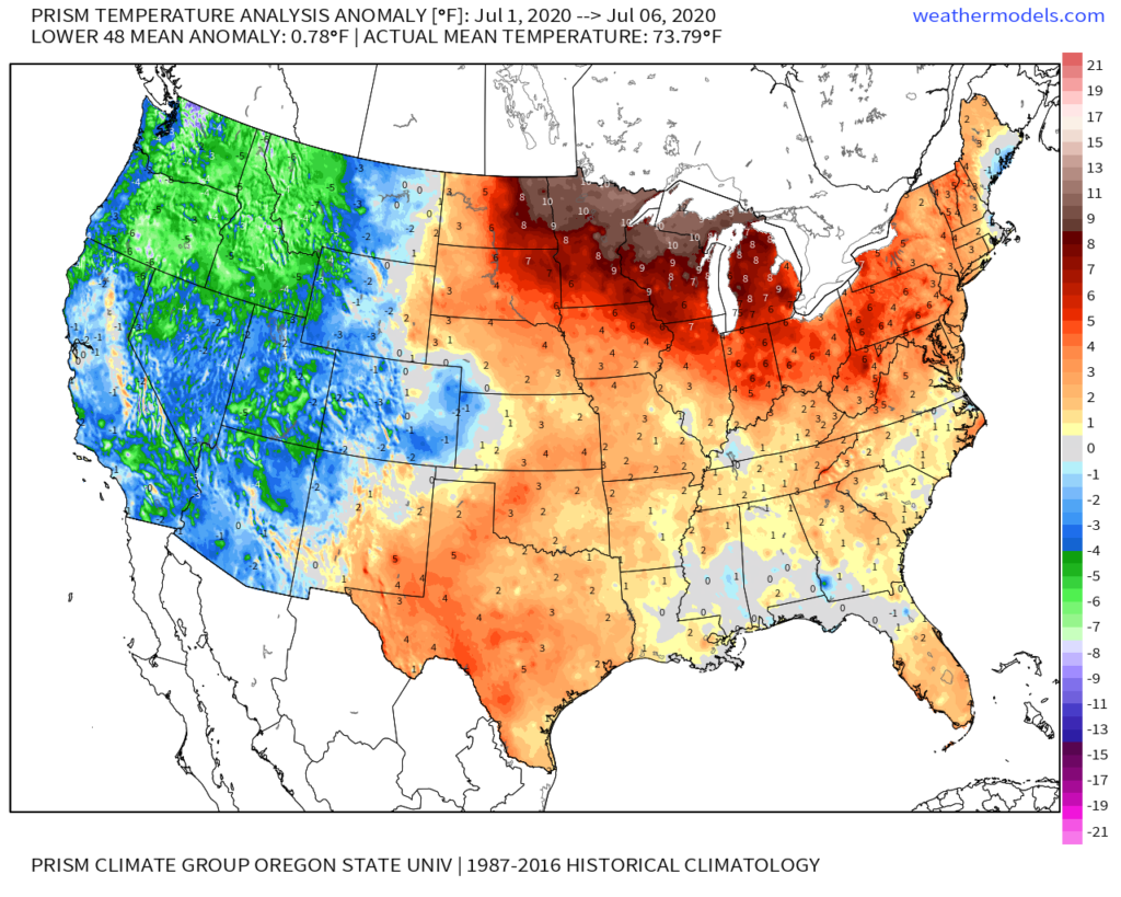
You don’t need us to tell you it’s been a hot month so far. Officially, IND is running 5.8° above average to open the month. At least compared to normal, even greater warm anomalies can be found across the upper Midwest and northern Great Lakes. Meanwhile, the West has been running exceptionally cool.

We’re actually running slightly above normal in the rainfall department (+0.17″) month-to-date at IND. As is typical this time of year, there are your usual “haves and have nots,” but the fact of the matter is that there have been many more neighborhoods that have seen beneficial rains vs. not over the past week.

The remainder of the work week will continue to feature “splash and dash” variety of storms, especially in the afternoon and evening. We believe better overall coverage of rain can be expected by late week and into the weekend. The culprit? The ‘mean’ upper ridge will retrograde southwest and a cold front and associated upper level energy will move southeast across the Ohio Valley. This will also deliver cooler, or “less hot” conditions. We’ll replace highs in the low-mid 90s with highs in the mid-upper 80s and lows in the lower to middle 60s.

Recent trends continue to suggest the core of the upper ridge will once again move northeast as we move into Week 2. While it doesn’t appear as if this will have staying power to the likes of what we’re currently seeing, we would anticipate an uptick in the heat/ humidity again in the Week 2 time period (more particular July 14th through 19th). Additionally, organized rain chances will once again transition to the splash and dash variety.

Thereafter, we believe the ridge will settle into the central Plains and it’s here that we expect hottest and driest weather to wrap up the month. The transitional regime continues over the next few weeks with periods of the heat pulling back followed by resurgence…
Permanent link to this article: https://indywx.com/july-to-date-and-where-we-think-were-going-the-rest-of-the-month/
Jul 06
VIDEO: Pullback In The Heat This Weekend, But Growing Concern It Returns With Authority In The Longer Range…
You must be logged in to view this content. Click Here to become a member of IndyWX.com for full access. Already a member of IndyWx.com All-Access? Log-in here.
Permanent link to this article: https://indywx.com/video-pullback-in-the-heat-this-weekend-but-growing-concern-it-returns-with-authority-in-the-longer-range/
