Updated 05.18.21 @ 8:31a
You must be logged in to view this content. Click Here to become a member of IndyWX.com for full access. Already a member of IndyWx.com All-Access? Log-in here.

May 18
Updated 05.18.21 @ 8:31a
You must be logged in to view this content. Click Here to become a member of IndyWX.com for full access. Already a member of IndyWx.com All-Access? Log-in here.
Permanent link to this article: https://indywx.com/video-the-heat-is-on-2/
May 17
Updated 05.17.21 @ 4:51p
You must be logged in to view this content. Click Here to become a member of IndyWX.com for full access. Already a member of IndyWx.com All-Access? Log-in here.
Permanent link to this article: https://indywx.com/evening-video-stormy-at-times-now-but-a-drier-trend-develops-for-the-2nd-half-of-the-week-mjo-plays-a-big-role-to-close-may-open-june/
May 14
Updated 05.14.21 @ 6a
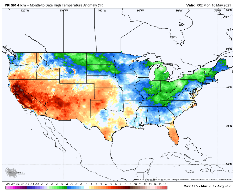
It sure has been a chilly 1st half of the month (temperatures at IND are now running more than 7° below average to-date). Widespread chilly air has dominated so far this month from the upper Plains into the Ohio Valley, Northeast, and now into the Southeast.

The primary driver of this pattern has the been the MJO rolling through (with great amplitude) the chilly phases for this time of year.
As we look ahead, the upcoming week will feature a relaxation of the chilly regime and an upper pattern that most would come to expect for mid and late May. Note how the persistent trough is replaced with a building ridge in the week ahead. This will allow a warmer and more humid air mass to flow north (courtesy of the southerly air flow of the Gulf of Mexico).

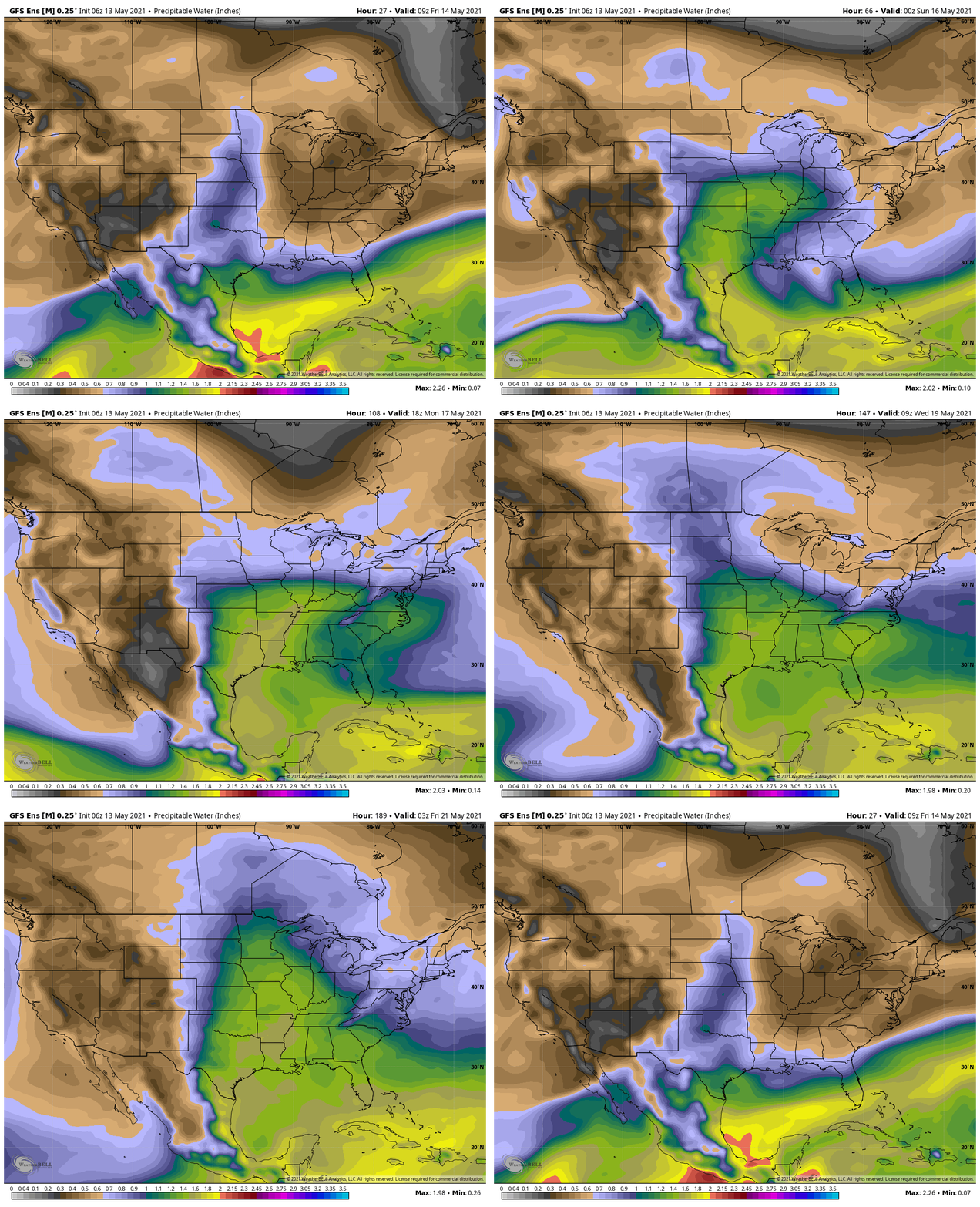
Subsequently, notice how the cool, crisp air is replaced with increasingly humid (shades of green) air in the week ahead. This more muggy feel will come at us in a couple of surges (early week with those storm chances increasing) and then again midweek after a briefly drier airmass likely takes hold Tuesday.

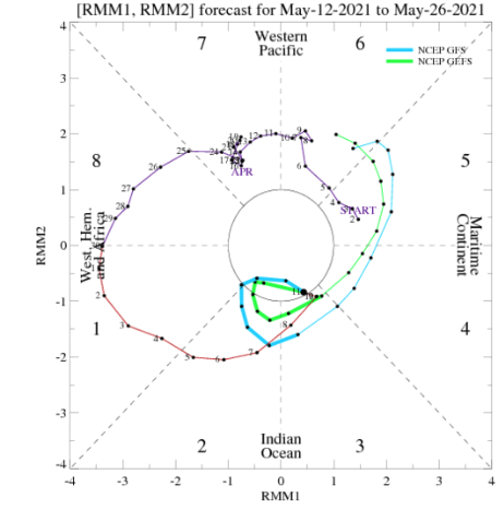
Longer term, the driver (as has been the case to open May) sure seems to be the MJO, but we note guidance isn’t in agreement. Given what’s going on in the Pacific, we tend to lean towards the GEFS and the more aggressive path into Phases 5-6 by late month.

Should this, indeed, be the case, we’d expect a true summer-like feel to blossom across our neck of the woods around Memorial Day. Note Phase 6 is the “king” of heat this time of year.

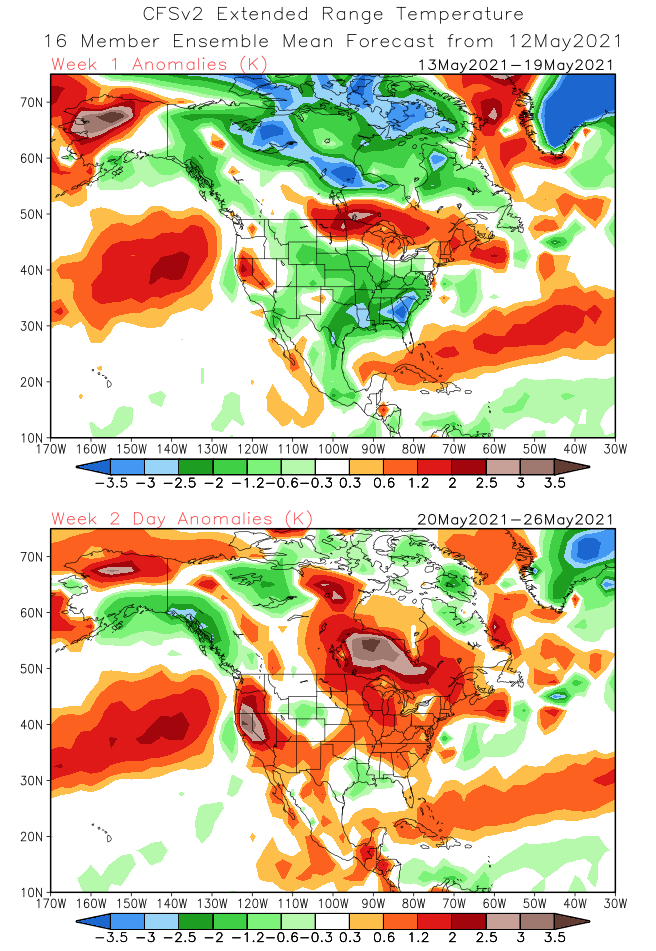
It seems as if model guidance is trying to see this, but I’d still caution the temperature forecast in the Week 2-3 time frame isn’t warm enough just yet, and likely still has room for further warming as we move forward. Just something to keep an eye on as we push forward. Remember we showed the latest JMA Weeklies in yesterday’s video. While I think that model looks good for the most part, I disagree with the way it’s handling the period around Memorial Day and would lean more in the direction of the CFSv2 warm/ hot look below. While I don’t think the heat will last, I still fully expect us to finish May vastly different than what we’ve enjoyed as of late… (More on the June pattern later).

Permanent link to this article: https://indywx.com/long-range-update-pattern-drivers-as-the-unofficial-start-of-summer-approaches/
May 13
Updated 05.13.21 @ 8:30a
You must be logged in to view this content. Click Here to become a member of IndyWX.com for full access. Already a member of IndyWx.com All-Access? Log-in here.
Permanent link to this article: https://indywx.com/video-cool-crisp-air-dominates-to-close-the-work-week-analyzing-timing-and-where-heavy-rain-sets-up-early-next-week/
May 11
Updated 05.11.21 @ 7:51a
You must be logged in to view this content. Click Here to become a member of IndyWX.com for full access. Already a member of IndyWx.com All-Access? Log-in here.
Permanent link to this article: https://indywx.com/video-reasons-why-a-significant-pattern-change-may-arrive-prior-to-memorial-day/