Category: Long Range Discussion

Initial Analog Set For Winter ’23 – ’24…

Updated 09.03.23 @ 9:22a

The extended stretch of quiet weather has given us time to finalize the initial set of analogs we’ll lean in on for the upcoming winter. Speaking of that, our annual Winter Outlook will be published Friday, October 27th.

While long range seasonal models differ on the placement of warmest sea surface temperature (SST) anomalies, we’re refraining from going “all-in” on a modoki Nino event as of now. This is something that no doubt will have our attention as we go through the course of the next several weeks. It’ll be interesting to watch the trends. The modoki, or central based, warm event would go a long way in upping the ante for a colder, stormier winter, locally. This is something that’s possible but we still have more questions than answers with how this evolves.

SST configuration as of September 1, 2023:

Our initial set of analogs includes the following years:

  • 1957-1958
  • 1972-1973
  • 1991-1992
  • 2002-2003
  • 2009-2010
  • 1982-1983
  • 2015-2016

We’re looking at 1st year Nino events of moderate to strong intensity. (Most modeling peaks this event in the +1.5 to +2 range in Nino region 3.4). In addition, we’re also looking at critical SST configuration in the NPAC and northwest Atlantic. Out of the list above, heaviest focus as of now centers on ’82-’83, ’91-’92, ’02-’03, ’09-’10, and ’15-’16.

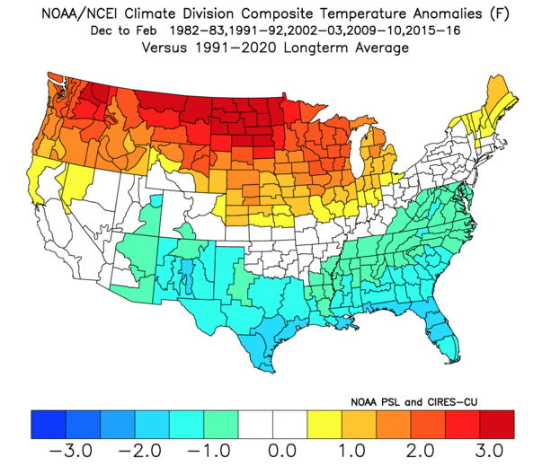
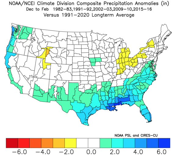
A blend of those years gives us the following temperature and precipitation pattern for meteorological winter:

Temperature
Precipitation
There’s a lot more that goes into our seasonal outlooks than simply taking a blend of analogs, but this will serve as a nice starting point from this distance. It’ll be very interesting to watch the migration (or lack thereof) of warmest SSTs currently “tucked in” to Nino regions 1+2 and 3 into potentially a more central, or region 3.4 event.

Make it a great Labor Day weekend and know we’ll have much more to come in the weeks ahead on our winter ’23 – ’24 thoughts…

Permanent link to this article: https://indywx.com/initial-analog-set-for-winter-23-24/

VIDEO: Quiet Labor Day Weekend With Moderating Temperatures…

Updated 08.31.23 @ 7:45a The extended stretch of calm, quiet conditions will allows us to start looking ahead to the upcoming winter in earnest over the upcoming several days. We’ll…

You must be logged in to view this content. Click Here to become a member of IndyWX.com for full access.  Already a member of IndyWx.com All-Access?  Log-in here.

Permanent link to this article: https://indywx.com/video-quiet-labor-day-weekend-with-moderating-temperatures/

VIDEO: Extended Quiet Stretch; Hint Of Fall Gives Way To Unseasonably Hot Stretch Next Week…

Updated 08.30.23 @ 7:40a

You must be logged in to view this content. Click Here to become a member of IndyWX.com for full access.  Already a member of IndyWx.com All-Access?  Log-in here.

Permanent link to this article: https://indywx.com/video-extended-quiet-stretch-hint-of-fall-gives-way-to-unseasonably-hot-stretch-next-week/

Pleasant Start To Our Labor Day Weekend; Significant Heat Returns Next Week…

Updated 08.29.23 @ 7:15a

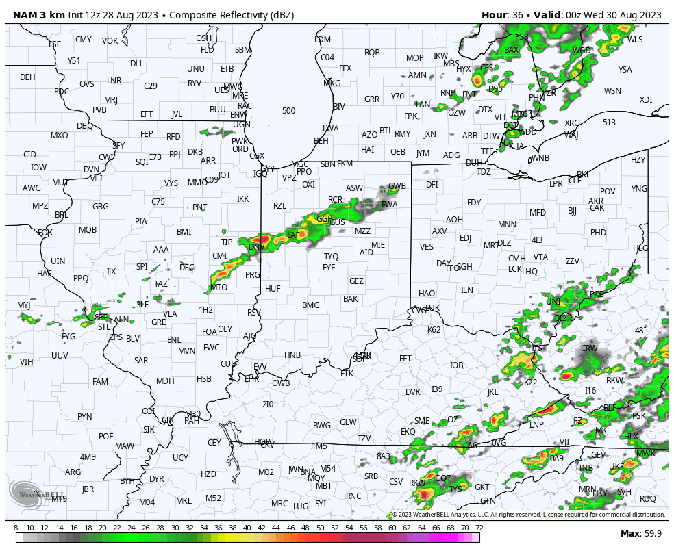
A weakening band of showers will push into north-central Indiana later this evening. A quick shower May move through the city but most should remain dry as the associated secondary cold front passes through the area. This frontal passage will serve up dry, cool air reinforcements that will carry us into the start of our Labor Day weekend. Overnight lows into the 40s can be expected.

A quick shower is possible this evening, primarily north of the city

Our “hint” of fall will quickly fade through the holiday weekend and into next week as the upper ridge builds northeast. This won’t only deliver unseasonably hot and humid conditions but will keep us much drier than normal. In fact, after today, I don’t see any meaningful chances of precipitation for at least the upcoming 10-day stretch.

Permanent link to this article: https://indywx.com/pleasant-start-to-our-labor-day-weekend-significant-heat-returns-next-week/

About As Quiet As It Gets; Another Round Of Major League Heat On Deck As We Move Into Early September…

Updated 08.28.23 @ 12:25p

A secondary cold front will drop southeast across the state Tuesday. While we’re not anticipating any sort of widespread significant rain and storms with this frontal passage, it will be the best opportunity for rain over the next 10-14 days, overall. Best chances of precipitation will come after 5p from a weakening line of showers and storms to our northwest.

Best chances of measurable rain will be to the northwest of immediate central Indiana.

Reinforcing dry, cool air will filter into the region as we close the work week and get set to head into the Labor Day weekend. Here’s a bit of advice: please be sure to make time to get outside and enjoy this pleasant airmass as major changes await over the weekend and into next week. Until then, our late week stretch will feature overnight lows dipping into the upper 40s and lower 50s.

The upper ridge will begin to build back northeast over the holiday weekend and with it will come another round of unseasonably hot, humid conditions. While it might not be quite as miserable as what we dealt with last week, chances are that we’ll have to contend with several days of 100°+ heat indices and “jungle-like” humidity with an extended period of rain-free days deep into the Week 2 timeframe. Buckle up.

Permanent link to this article: https://indywx.com/about-as-quiet-as-it-gets-another-round-of-major-league-heat-on-deck-as-we-move-into-early-september/