You must be logged in to view this content. Click Here to become a member of IndyWX.com for full access. Already a member of IndyWx.com All-Access? Log-in here.
Updated 05.28.25 @ 7:35a A couple of disturbances will move through the region between now and the end of the short work week. Shower coverage will be greatest today across…
You must be logged in to view this content. Click Here to become a member of IndyWX.com for full access. Already a member of IndyWx.com All-Access? Log-in here.
Updated 05.23.25 @ 7:53a Cool, Canadian high pressure will supply a return of dry (and sunny) conditions as we roll into the big, exciting holiday weekend. While we’ll be cooler…
You must be logged in to view this content. Click Here to become a member of IndyWX.com for full access. Already a member of IndyWx.com All-Access? Log-in here.
Updated 05.17.25 @ 9:55a High pressure will supply dry conditions and plentiful sunshine through the weekend. It’ll even be a bit on the chilly side to open things up Sunday…
You must be logged in to view this content. Click Here to become a member of IndyWX.com for full access. Already a member of IndyWx.com All-Access? Log-in here.
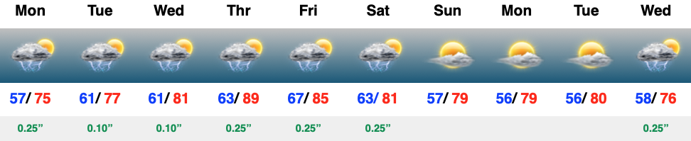
The upper low that’s been impacting the Deep South for the past several days is finally starting to lift north. That means our region will start to turn more unsettled today with showers and embedded thunder lifting in from the south. It won’t rain the entire time by any stretch of the imagination, but we should be prepared for at least scattered coverage of showers/ t-storms from this feature through Wednesday (less coverage Wednesday compared to that of today and Tuesday).
Then attention will shift to an approaching cold front Thursday afternoon and evening. As the front slices into a warm, unstable, and humid airmass, strong to severe thunderstorms will be possible here Thursday afternoon and into the evening.