Category: Jet Stream Discussion

Long Range Report: Warm Open To Meteorological Spring; MJO And NAO Impacts Longer Term…

Updated 02.29.24 @ 5:13a

Tomorrow we’ll welcome in meteorological spring and the first couple weeks of March appear to continue the unseasonably warm trend. At times, additional warm records will likely fall.

A ‘mean’ eastern ridge (and strong western trough) will dominate the 1st half of March.
Well above average temperatures are expected through the 1st half of March.

This is strongly correlated with the Madden-Julian Oscillation highly amplified in the classic warm phases this time of year. (You can absolutely say goodbye to any sort of sustained cold prospects this time of year with the MJO in phases 4, 5, and especially 6). Now, down the road, we’ll want to watch and see if we can maintain this amplitude and rumble into the transitional colder Phase 7 before a potential opportunity to see cold grow more impressive should we *finally get into Phase 8 late month. Remember that we made an attempt at that back in mid-February before things instead collapsed into the neutral phase. Moral of the story for folks longing for one more bout of sustained cold prior to the warmer months ahead, “don’t hold your breath.” The trend certainly isn’t your friend.

Back to the present. No matter what the teleconnections say, an amplified MJO will always win out. And the current MJO forecast to roll through the phases listed above screams that our recent warm times will “keep on keepin’ on” as we navigate the 1st half of March.

MJO forecast through March 13th

The Phase 5 and Phase 6 composite analogs at 500mb (upper air pattern) for an El Niño March:

What this should also result in is an active first half of the month, including above normal rainfall and likely at least another early season strong to severe weather event before we get to mid month.

It’s a classic pattern that should feature low pressure systems ejecting out of the Southwest and South-central into the Plains and western Great Lakes region. That puts our neck of the woods on the warm/ wet (and at times stormy) side of the equation.

As we move into late-March and early April, we’ll have our eyes focused on the MJO and whether or not we can, indeed, get into those traditionally colder phases. Stay tuned.

Permanent link to this article: https://indywx.com/2024/02/29/long-range-report-warm-open-to-meteorological-spring-mjo-and-nao-impacts-longer-term/

Evening VIDEO: Mild Pattern Comes With Heavy Rain/ Storm Risk In The Days (And Weeks) Ahead…

Updated 02.20.24 @ 6:22p With the exception of a couple cooler (can’t even call it “cold” by late February/ early March standards) days, the pattern over the upcoming couple weeks…

You must be logged in to view this content. Click Here to become a member of IndyWX.com for full access.  Already a member of IndyWx.com All-Access?  Log-in here.

Permanent link to this article: https://indywx.com/2024/02/20/evening-video-mild-pattern-comes-with-heavy-rain-storm-risk-in-the-days-and-weeks-ahead/

Digging Our Heels Into The Pattern Over The Next 2 Weeks…

Updated 06.22.23 @ 4:45a

You must be logged in to view this content. Click Here to become a member of IndyWX.com for full access.  Already a member of IndyWx.com All-Access?  Log-in here.

Permanent link to this article: https://indywx.com/2023/06/22/digging-our-heels-into-the-pattern-over-the-next-2-weeks/

Potential Pre-Christmas Winter Storm; MJO Impacts On The January Pattern…

Updated 12.13.22 @ 9:48p

You must be logged in to view this content. Click Here to become a member of IndyWX.com for full access.  Already a member of IndyWx.com All-Access?  Log-in here.

Permanent link to this article: https://indywx.com/2022/12/13/potential-pre-christmas-winter-storm-mjo-impacts-on-the-january-pattern/

Something’s Got To Give…

Updated 10.03.22 @ 5:32p

The NEW European Weeklies are in and continue to paint an intriguing picture as we look ahead to November. Remember, we’re of the belief that the pattern may, indeed, get off to a fast start to the winter season (for a change) this year.

At any rate, note the evolution at 500mb continues to up the ante that this idea may be right as we rumble into mid-November.
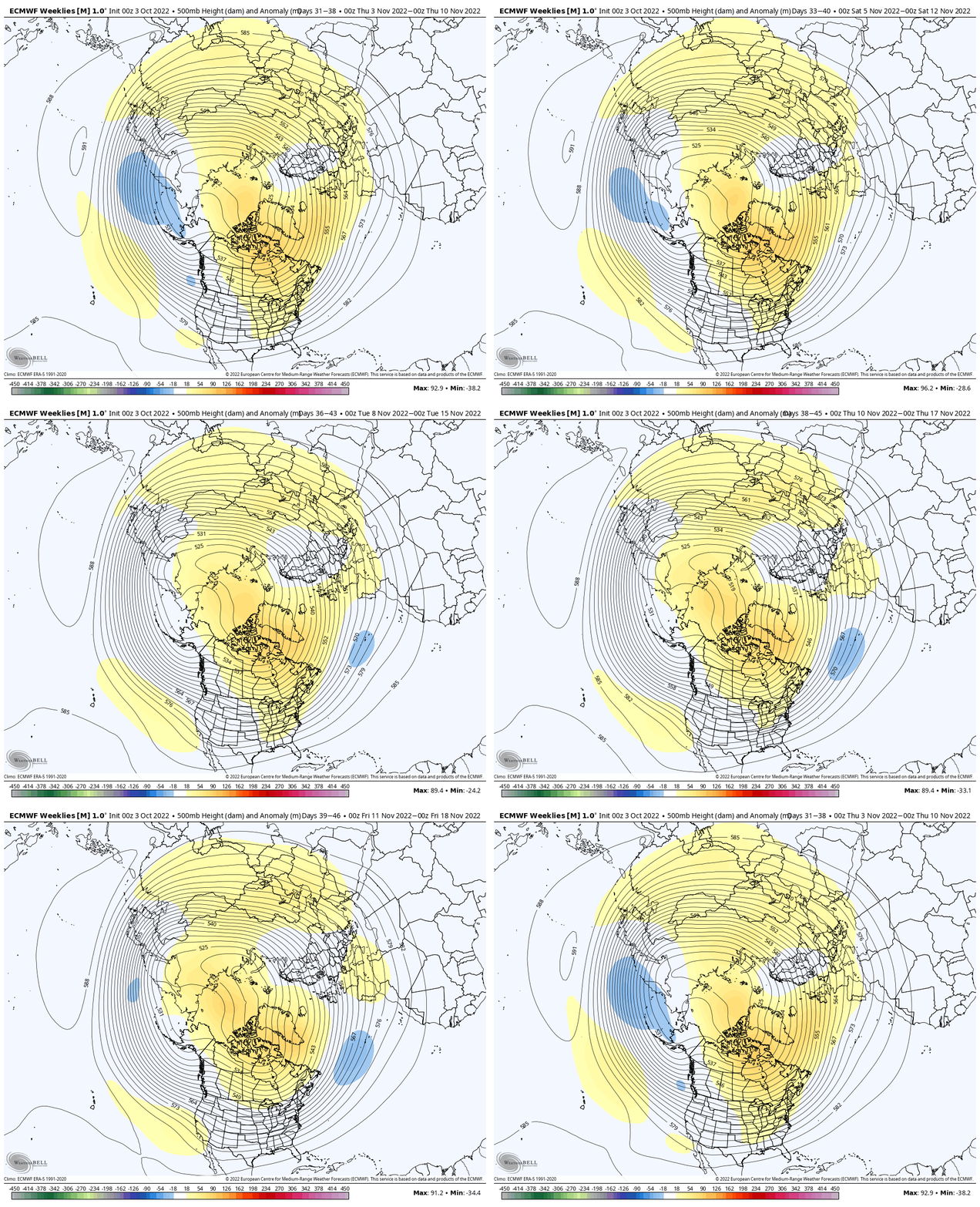
However, at the surface, the European doesn’t display the type of cooling one would imagine given the upper air pattern look.

My hunch is that we’ll see the trough “tuck in” further west to include a good portion of the central and east as we move forward and zone in on that mid-November time frame. That will likely force the surface temperature anomalies above to cool (significantly so if this idea is correct) for that time period.

It’ll be interesting to see what the update European seasonal product says in a couple of days. We’ll include that in Thursday’s long range update.

Permanent link to this article: https://indywx.com/2022/10/03/somethings-got-to-give/

Winter Isn’t Done Yet…

Updated 03.02.22 @ 7:56p

The Madden Julian Oscillation (MJO) is back in the null, or neutral, phase.

That means it’s time to start leaning heavier on the teleconnection blend. This time of the year, that encompasses all, including the NAO.

As we look over the course of the upcoming 10-14 days, we note rather strong alignment between the teleconnections favoring a return of a cold pattern. That is, of course, after the taste of spring that will continue into the day Sunday (aside from one “speed bump” tomorrow).

We note the EPO, or East Pacific Oscillation, is forecast negative until around the 12th and then back towards neutral. This is a cold signal for the east, relative to average.

The NAO (North Atlantic Oscillation) is forecast neutral through the bulk of the upcoming couple weeks. – Likely won’t have a significant impact on the overall pattern.

The PNA (Pacific North American pattern) is forecast negative through the 13th before trending neutral. This should allow a southeastern ridge to remain in play to at least some degree which suggests a very active storm track into the Ohio Valley. As the colder air pushes east and runs up against the resistance from the southeastern ridge, late season wintry threats loom towards mid month.

Finally, the WPO (West Pacific Oscillation) is forecast strongly negative which also implies cold should try and fight east.

With all of that said above, we note the ensemble guidance (both the EPS and GEFS) brings the trough back into the central and eastern portion of the country as we move out of the Day 1-6 period and suggests it’s far too early to think about putting away those winter clothes, or even the snow removal equipment just yet…

Upper air pattern- March 3-8
Upper air pattern- March 8-13
Upper air pattern- March 12-17

Note the colder than normal temperatures spilling back into the region next week and the week beyond.

We’re likely far from finished with snow or wintry precipitation either…

Permanent link to this article: https://indywx.com/2022/03/02/winter-isnt-done-yet/

VIDEO: Initial Thoughts Around Winter 2021-2022…

Updated 09.19.21 @ 10:20a

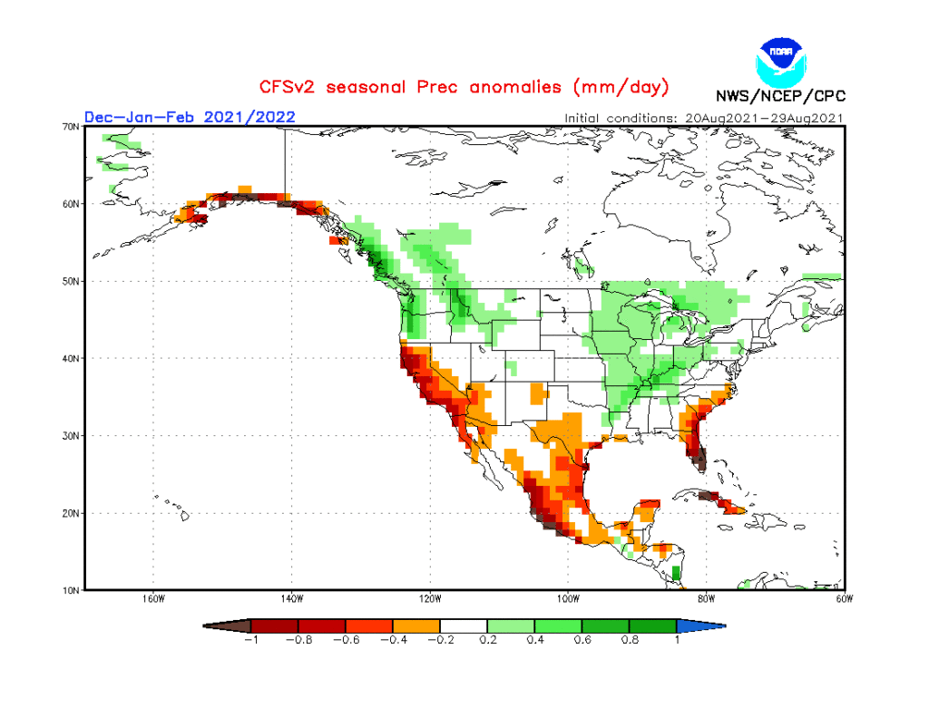
As the first strong autumn cold front takes aim on the region, it’s time to start thinking more about what lies ahead in the December-February time frame. This morning’s video dives in with some initial thoughts around just that. Is the CFSv2 seasonal precipitation projection an indication of the active winter storm track ahead? We think so…
Permanent link to this article: https://indywx.com/2021/09/19/video-initial-thoughts-around-winter-2021-2022/

VIDEO: Snowy Weekend And Fresh Ideas Around The System Late Next Week…

Updated 01.15.21 @ 6:27p

You must be logged in to view this content. Click Here to become a member of IndyWX.com for full access.  Already a member of IndyWx.com All-Access?  Log-in here.

Permanent link to this article: https://indywx.com/2021/01/15/video-snowy-weekend-and-fresh-ideas-around-the-system-late-next-week/

VIDEO: Stormy 24 hours Ahead; Amplified Pattern This Week…

You must be logged in to view this content. Click Here to become a member of IndyWX.com for full access.  Already a member of IndyWx.com All-Access?  Log-in here.

Permanent link to this article: https://indywx.com/2020/09/06/video-stormy-24-hours-ahead-amplified-pattern-this-week/

VIDEO: Ready For A Refreshing Change? Discussing Precipitation Chances Next Week…

You must be logged in to view this content. Click Here to become a member of IndyWX.com for full access.  Already a member of IndyWx.com All-Access?  Log-in here.

Permanent link to this article: https://indywx.com/2020/05/29/video-ready-for-a-refreshing-change-discussing-precipitation-chances-next-week/

IndyWx.com