Category: JAMSTEC

Long Range Update: Extended Dry Pattern Rolls Along; New Winter Seasonal Data Is In…

Unfortunately there likely won’t be any significant changes to our precipitation pattern until late autumn and winter. Until then, we’ll have to take any drop of rain we can find. Once the pattern flips though, it may do so in quick and rather dramatic fashion (still expecting a wet winter).

The consensus of long range data shows the dry pattern continuing over the upcoming few weeks, including the JMA Weeklies, CFSv2 Weeklies, and ensemble products.

Analogs and other teleconnections support this dry theme. At least in the immediate range (through mid October) the only way to bust up this dry pattern is to get tropical moisture involved.

The new JMA Weeklies maintain the ‘mean’ ridge position across the West for the majority of the upcoming few weeks, but there will likely be attempts to expand the ridge across the northern tier Week 2 and 3 that would lead to at least transitional periods of much warmer air, after the cool period in the short term.

The model sees the ridge expanding Weeks 3-4 and the associated warmth that spreads east after the chilly regime.

The new JAMSTEC seasonal data is also in and maintains a warm look this winter. A lot of this has to do with an expected persistent southeastern ridge. We agree with this but, as is the case each winter, there will be challenges that have to be dealt with.

We also agree with the active storm track through the Ohio Valley and associated well above normal precipitation in the December through February period.

Permanent link to this article: https://indywx.com/2020/09/17/long-range-update-extended-dry-pattern-rolls-along-new-winter-seasonal-data-is-in/

Long Range Update: Closing Out August…

With a little over 2 weeks to go in meteorological summer, model data disagrees in the way the month- and season ends. That is, after the upcoming week where the consensus is cooler and drier than normal (we agree, as well). Let’s take a look at the data:

European Weeklies

Week 1

CFSv2

Week 1

GEFS

Week 1

EPS

Week 1

JMA

Week 1

The American data and JMA Weeklies are coolest (compared to the European), but compared to Weeks 2 and 3, there’s better consensus. The initial week is also looking drier than normal- especially after a “smattering” of storms tomorrow and Saturday.

Week 1 Precipitation anomalies- JMA Weeklies
Week 1 Precipitation anomalies- European ensemble

Let’s now take a look at Week 2:

European Weeklies

Week 2

CFSv2

Week 2

GEFS

Week 2

EPS

Week 2

JMA

Week 2

This is where our idea begins to pivot more towards the JMA Weeklies and European data (warmer look). The reason primarily has to do with the MJO moving back into Phase 8 during this time period.

This is a warm phase in August.

Furthermore, the PNA ‘mean’ is forecast to trend off the positive “mountain” (that will help drive the cooler pattern for the upcoming week) and more towards neutral.

Phase 1 is also a warmer look for our part of the country and that’s the way we’re leaning for the last week of the month (despite the very cool CFSv2).

While not overly warm, we think the JMA has the best handle on the temperature pattern in the Week 3 timeframe, locally (seasonable to slightly above normal).

The pattern should also begin to trend wetter during this time period:

This matches up with Phase 1 of the Madden Julian oscillation:

So, to summarize, after a cool and dry period next week, we anticipate the pattern to trend warmer (more seasonable) and wetter to close the month and head into early September. One other item of note is that the tropics should really begin to heat back up during this period, as well. Of course, as is the case from time to time, that can be a wild card from a precipitation perspective. The Gulf of Mexico (GOM) looks particularly busy late August through late September, but there’s simply no way to get more specific from this distance, including potential inland impacts. It’s worth keeping a close eye though.

Before we leave, the latest JAMSTEC seasonal data updated this morning and features a “torch” of a fall, along with a warm, wet winter, locally. That southeast ridge will have to be dealt with this winter. While still early, the early lean is for a warm start to winter (including holiday season). While there are some ingredients that may keep things more interesting than what they could be otherwise, from at least this point, this doesn’t appear as if it’ll be an “exciting” winter for lovers of snow and cold. Much more later- and again, we still have a long way to go…

Permanent link to this article: https://indywx.com/2020/08/13/long-range-update-closing-out-august/

VIDEO: Drier Late Week Trends; Warm Meteorological Fall On The Way?

You must be logged in to view this content. Click Here to become a member of IndyWX.com for full access.  Already a member of IndyWx.com All-Access?  Log-in here.

Permanent link to this article: https://indywx.com/2020/08/13/video-drier-late-week-trends-warm-meteorological-fall-on-the-way/

Thoughts Begin To Shift To Fall (And Winter)…

While we still have a few weeks left of meteorological summer, we’re hard at work finalizing our fall outlook and prep continues for winter. By the way, our fall outlook will be online Friday morning, the 28th.

From this distance, there’s obviously a risk involved with seasonal data that we’re reviewing and tweaks (particularly to the initial winter idea) will undoubtedly have to be made. In short, we anticipate a weak La Niña to dominate the fall and winter, with a robust MJO.

Of course, it’s important to remember, no La Niña is like the other and a simple “broad brush” approach never works.

Without question, the tropics will claim headlines through the fall. Unfortunately, like others, we anticipate a significant uptick in activity late August into October. A few major hurricanes are likely, as well. The Gulf of Mexico and Carolina coast appears particularly vulnerable…

Most computer model data is leaning towards a warm autumn. We’d agree, overall, but leaning wetter than the majority of data right now, due in large part to tropical impacts.


European seasonal data for September through November.
CFSv2 seasonal data September through November.
CFSv2 seasonal data for September through November.
JAMSTEC seasonal data for September through November.

The coolest of the seasonal data is the CFSv2. It’s easy to interpret a cooler Central and East if the ridge and associated heat is so strong across the West. We will keep close tabs on trends over the next few weeks. Nina falls are notorious for at least a few weeks early on of unseasonably cool weather as well. Stay tuned.

As for winter, from this distance we’re bullish on a wetter, warmer than normal season, locally. Below normal snowfall is expected as of now. A dominant southeast ridge is expected to carry the day, at times flexing north into the TN and Ohio Valley.

European seasonal data November through January.
JAMSTEC seasonal data December through February
CFSV2 seasonal data December through February

Interesting, like fall, the CFSv2 is the “coolest” of the big 3 seasonal models. Again, we’ll continue to keep close eyes on trends. Given performance of recent winters past, you may say I’ll just go with the opposite of what these seasonal models say. You’d have good reason for doing so. Unfortunately, that southeast ridge almost seems like a lock though. It’s also becoming more difficult to ignore the trends over the past decade or two.

Much more later on both fall and winter! Enjoy your Sunday!

Permanent link to this article: https://indywx.com/2020/08/09/thoughts-begin-to-shift-to-fall-and-winter/

VIDEO: Week Ahead Outlook; Reviewing The New JAMSTEC Winter Update…

You must be logged in to view this content. Click Here to become a member of IndyWX.com for full access.  Already a member of IndyWx.com All-Access?  Log-in here.

Permanent link to this article: https://indywx.com/2019/09/16/video-week-ahead-outlook-reviewing-the-new-jamstec-winter-update/

2019 Spring Outlook…

2019 IndyWx.com Spring Outlook

Forecaster: Team; Date Issued: 02.16.19

Last spring was a tale of two seasons in itself. March (featured a foot of snow) and April were significantly colder than normal and then we shifted things to summer in May (the last month of meteorological spring was close to 10 degrees above normal). As a whole, it was a quiet severe weather season.

Despite the wild swings, at the end of the day, things “balanced out” nicely across the central Ohio Valley, including central Indiana.
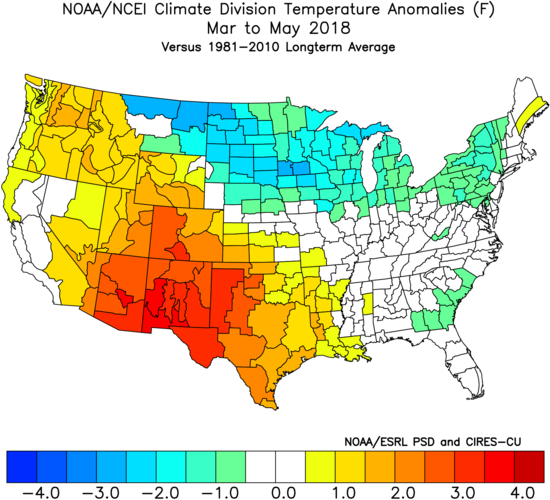
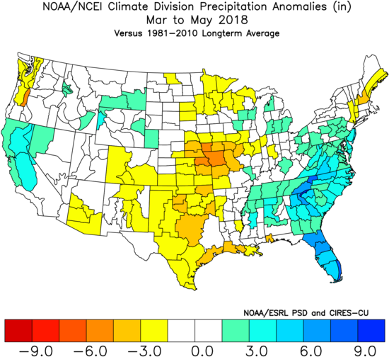
As we look ahead to what the 2019 version holds, here are a few headlines that have our attention:

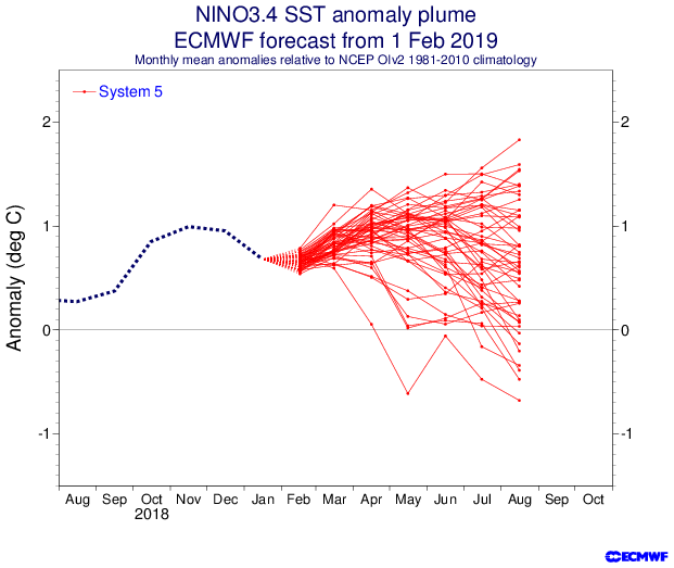
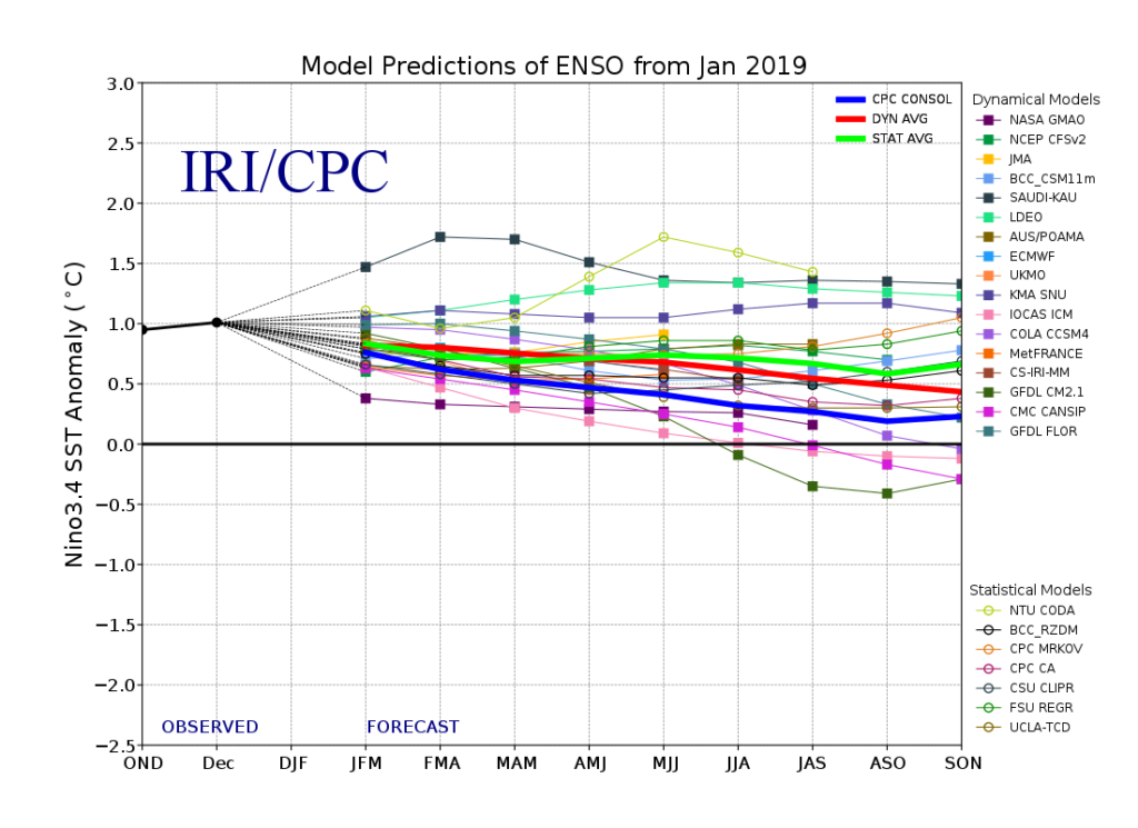
I. Weak Nino is behaving more like a Nina (Tropical Northern Hemisphere pattern can be thanked for this).
II. Neutral NAO is expected

III. Neutral PDO (Pacific Decadal Oscillation)

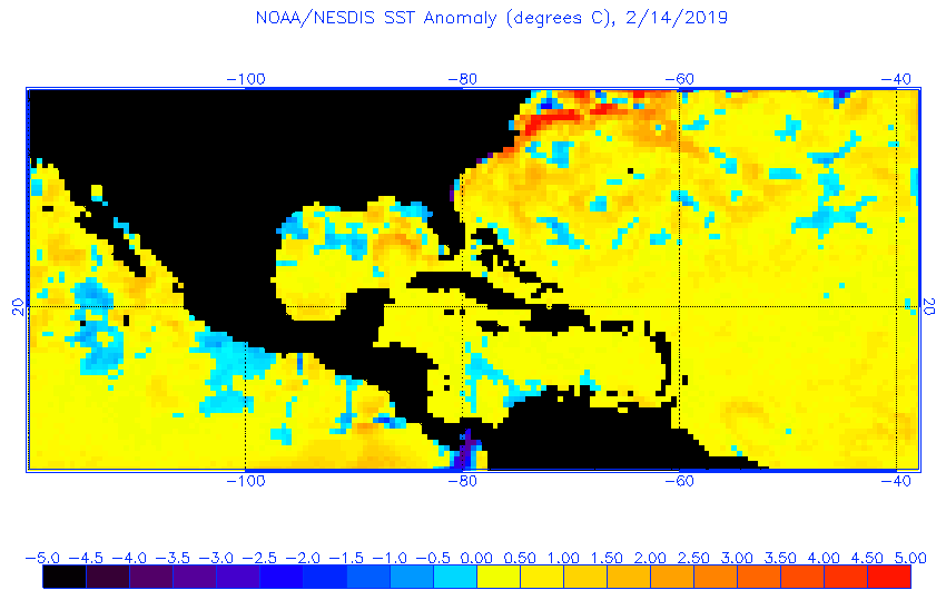
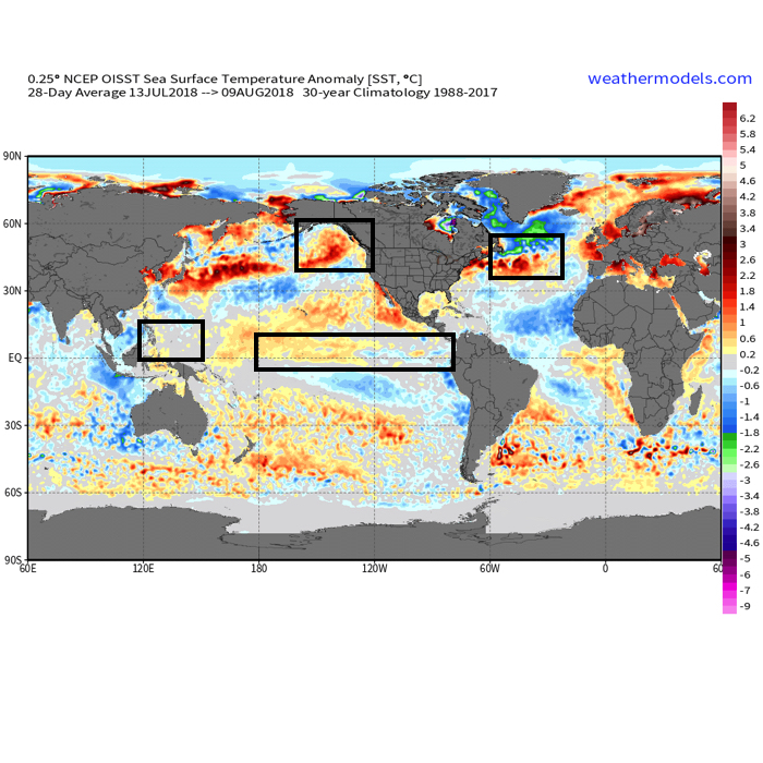
In addition, we’re paying special attention to the SST configuration in the Gulf of Mexico. A warmer than average GOM can most certainly lead to a more “hyper” severe weather season as spring gets going.
The late winter/ early spring drought monitor can give a hint where early warmth may try and get going. However, this year, we can’t rely on this tool as the Plains and East, including the heart of the #AGbelt, have seen copious amounts of moisture over the winter.
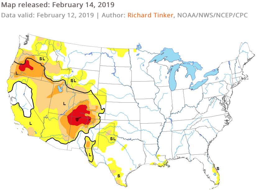
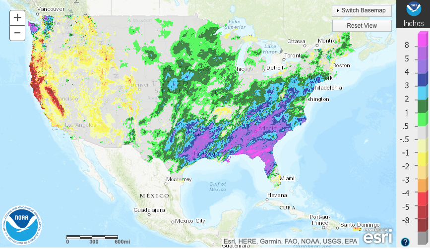
Drought Monitor as of 2/14/19
December 2018 Precipitation Anomalies
January 2019 Precipitation Anomalies

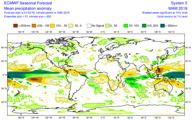
Let’s look at what the model guidance is printing out for meteorological spring:

JMA

March
April
May

CFSv2

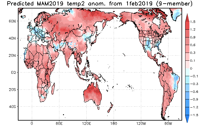
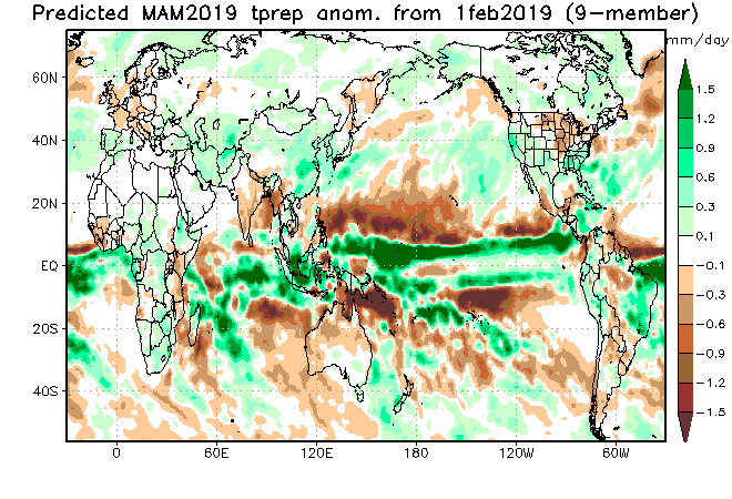
JAMSTEC

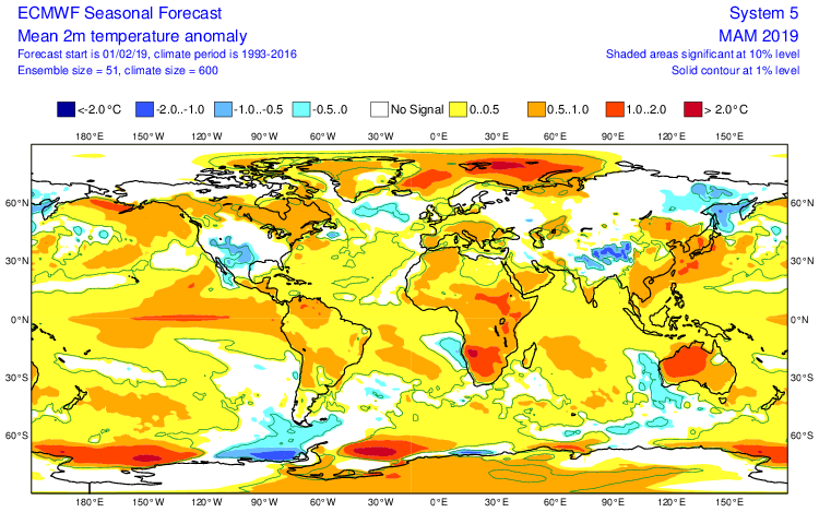
European Seasonal
Summary

We anticipate a slightly warmer than average spring season across not only central Indiana, but the Mid West and Ohio Valley region, as a whole. A weak El Nino is expected to persist into the upcoming summer and the conditions typically associated with such should eventually show themselves (as opposed to more of a Nina-like flavor now) through the spring. We agree with the consensus of model guidance above that March is likely to feature the coldest temperatures, relative to normal, and that’s primarily due to what should be a colder 1st half of the month before more bonafide spring conditions take hold the 2nd half of the month. Precipitation is anticipated to run near average, if not slightly below average, levels through the spring. As for severe weather, we expect a much busier season than last year, especially with the warm SSTs lurking in the Gulf of Mexico.

Permanent link to this article: https://indywx.com/2019/02/16/2019-spring-outlook/

Winter 2018-2019 Notes…

As the calendar turns from July to August, we really begin to increase the amount of research into the upcoming winter season.  While still a couple months out from publishing our official Winter Outlook, we did want to touch base on a couple of items.

The early “baseline” of our ideas focuses on the likelihood of El Nino returning for the upcoming winter season.  As we’ve stated many times in the past, each Nino event is different from one another and other ingredients (highlighted above) can play a significant role in ultimately determining the eventual outcome.
  • Weak Modoki (central-based) Nino is expected this winter
  • SST configuration in the NPAC (north Pacific) is perhaps the most “intriguing” item at the moment
  • Low solar/ QBO

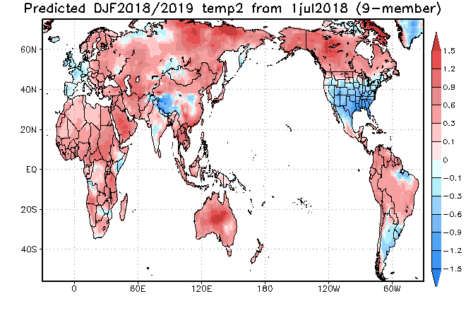
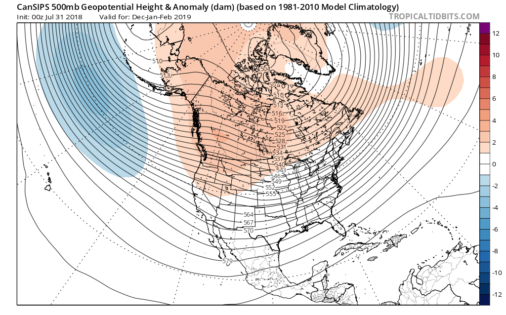
Somewhat of a surprise is that the majority of longer range, seasonal data is aligning for a cold, stormy eastern winter.  Included in the cold, stormy camp are the JAMSTEC, European, and CanSIPS.  A few snap shots are included below…

JAMSTEC Sea Surface Temperature Anomalies for meteorological winter (December through February).

JAMSTEC Surface Temperature Anomalies for meteorological winter.

CanSIPS 500mb for meteorological winter.

The CFSv2 is siding with a warmer winter, but it appears as if the model is struggling with the coming Nino and “over-hyping” things.  Accordingly, the model results in a blow torch winter.  Again, remember, we’re leaning towards a weak, central-based event.

That sea surface temperature configuration in the northern Pacific argues for western Canada ridging and downstream troughiness such as the JAMSTEC, European, and CanSIPS would imply.
Just wanted to touch base briefly on our early thinking before we release our official 2018-2019 IndyWx.com Winter Outlook in October.

Permanent link to this article: https://indywx.com/2018/08/15/winter-2018-2019-notes/

Winter Ideas…

We continue to finalize our winter forecast, which will be posted, as always, here later this month.

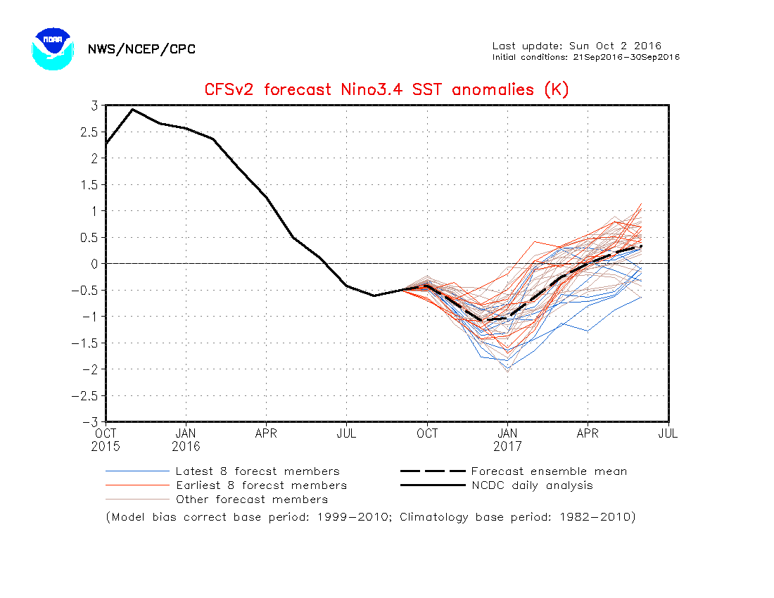
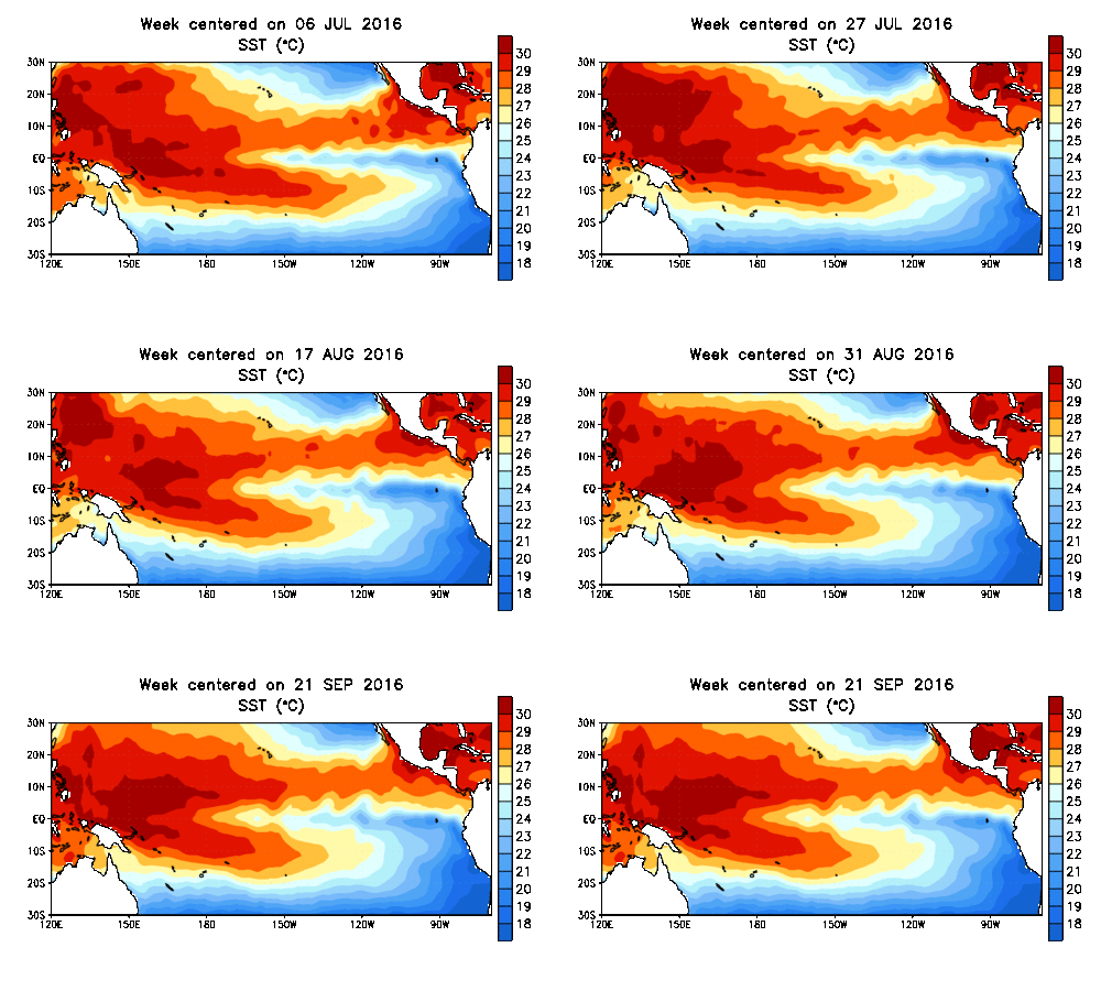
As little as only a few months ago, data suggested a major La Nina for the upcoming winter season.  That data has since backed off significantly.  In fact, some runs suggest we’re back into a weak-ish El Nino state by spring.  At the very least, we are confident on avoiding a strong La Nina this winter and lean more in the direction of a weak Nina, at best, to neutral signal.  The CFSv2 is interesting, as always, with the spread in region 3.4.

nino34monadj

sstanimIn addition to the central PAC anomalies, we also are keying in on some other items of interest in the overall SST configuration:
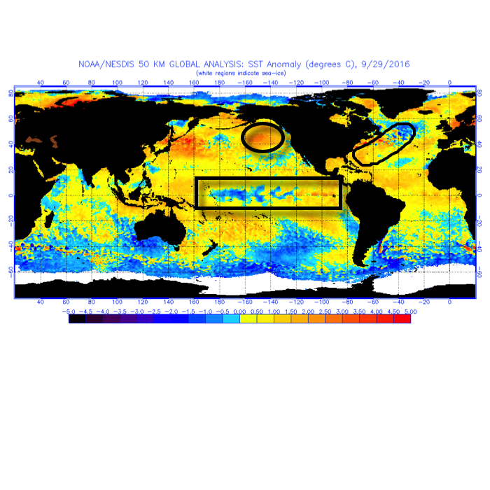
I. Warmth in the GOA (Gulf of Alaska)

Argues for central cold this winter, spreading east with time.

II. Warmth off the eastern seaboard

Will likely serve to limit the ability for the cold to spread east early on in the season

92916sstThe SST CA model is quickly becoming one of our more trusted seasonal forecast models.  We note how it becomes increasingly bullish on a central and eastern trough as winter wears on (by the way, this is likely to go deep into spring this year, too).
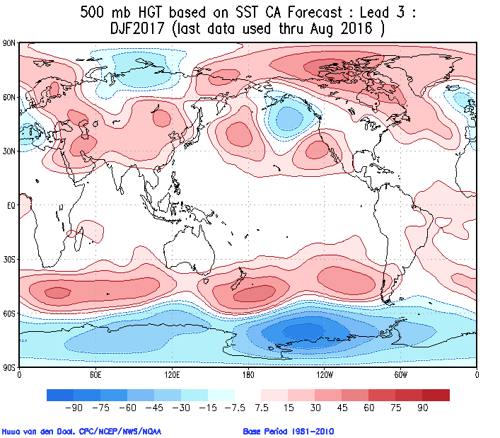
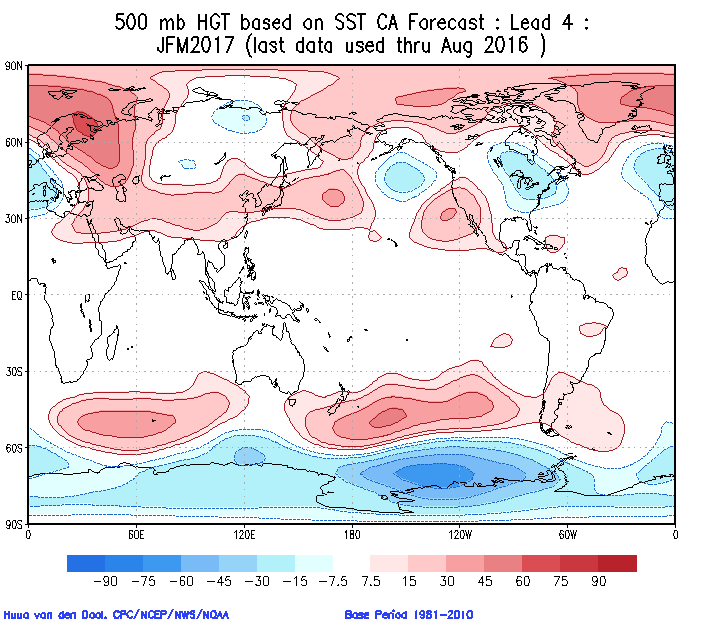
screen-shot-2016-10-02-at-10-52-54-am

screen-shot-2016-10-02-at-10-53-04-amCold overwhelms the pattern and when you combine it with the active storm track (noted by the green hues, suggesting above normal precipitation through our neck of the woods), confidence is continuing to grow for an above normal snow season.
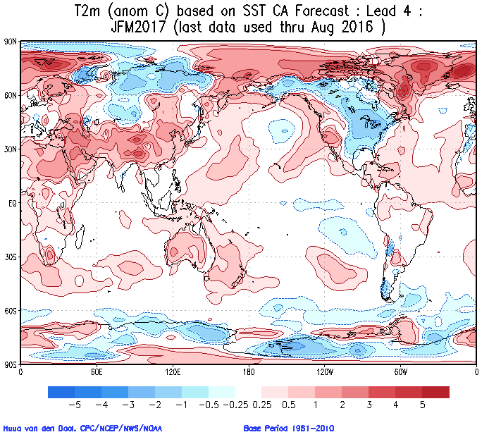
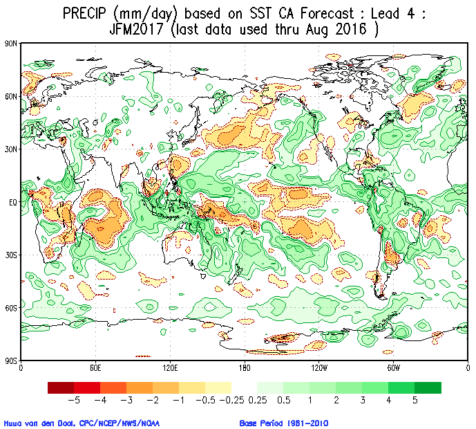
screen-shot-2016-10-02-at-10-58-16-am

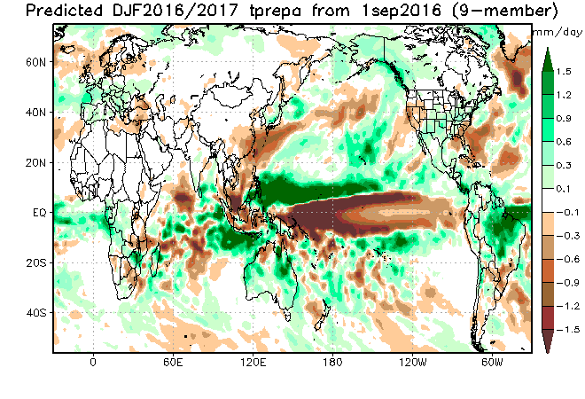
screen-shot-2016-10-02-at-10-58-05-amThe SST configuration on the JAMSTEC would suggest a cold, stormy set-up, locally.  That said, while it sees the above average precipitation, it’s awfully warm at the surface.
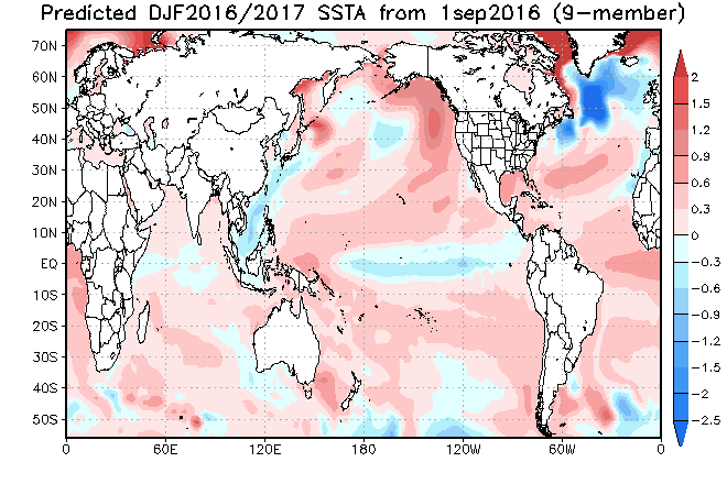
ssta-glob-djf2017-1sep2016

tprep-glob-djf2017-1sep2016

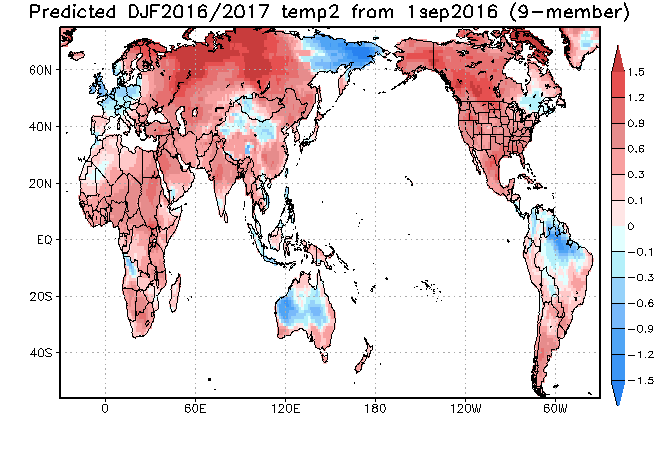
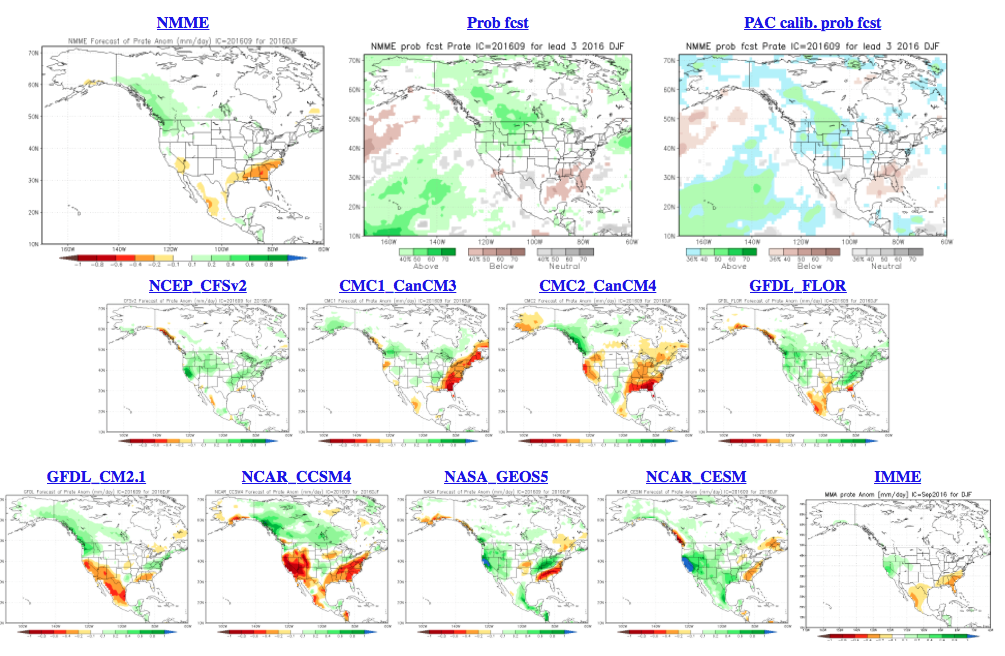
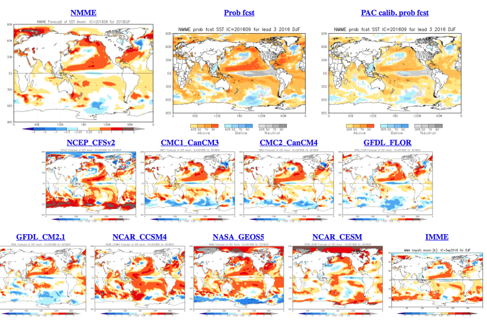
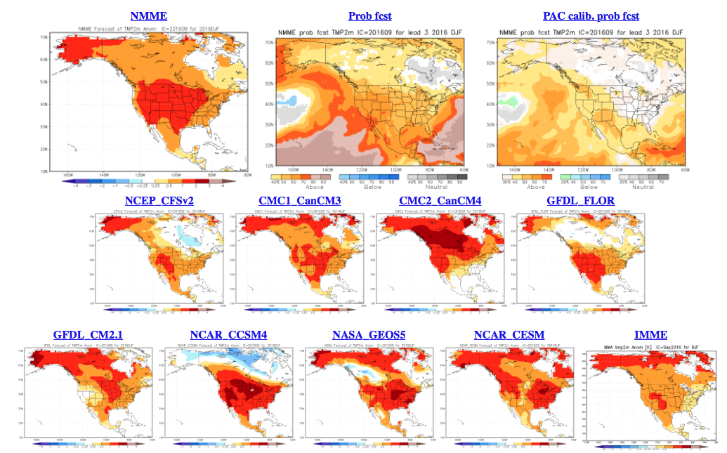
temp2-glob-djf2017-1sep2016The NMME (to no surprise…) would suggest a very warm, wet winter.
screen-shot-2016-10-02-at-11-08-26-am

screen-shot-2016-10-02-at-11-09-00-am

screen-shot-2016-10-02-at-11-08-47-amAs a reminder, our complete and final annual winter outlook will be posted here during the second half of October.  That will include additional model data, along with several other points behind our reasoning for our winter forecast.  As we always do, we’ll put “pen to paper” when it comes to our winter forecast, including our expected temperature and snowfall anomalies.  Given the data above, including the warm JAMSTEC and NMME, it’s going to be very, very hard to see a warm winter here.  In fact, our idea is for the exact opposite, given the SST configuration, and lines up more closely with the SST CA idea at this point.  We’re also in the camp of a very, very active storm track through the Ohio Valley.  “Big-hitter” potential is present from a winter storm perspective, especially given that we are likely to see resistance from the SE ridge.

Much more later this month…

Permanent link to this article: https://indywx.com/2016/10/02/winter-ideas/

Welcome To Meteorological Winter…

You must be logged in to view this content. Click Here to become a member of IndyWX.com for full access.  Already a member of IndyWx.com All-Access?  Log-in here.

Permanent link to this article: https://indywx.com/2015/12/01/welcome-to-meteorological-winter/

Very Windy Today; Next Big Storm Next Week…

Screen Shot 2015-11-12 at 7.17.23 AMHighlights:

  • Very strong winds
  • Dry times return
  • Big storm next week

A cold front swept through the state during the predawn hours.  While a few breaks of sunshine may be seen early this morning, low clouds will quickly spread back over the region.

Wind will be the big story today as we still think gusts over 50 MPH are a good bet throughout central parts of the state.  Note the tight pressure gradient that remains in place across the region today into Friday.  Friday won’t be AS windy as today, but still quite blustery.

gfs_ptype_slp_conus2_3

gfs_ptype_slp_conus2_7Our next big weather maker will arrive during the early to middle portions of next week.  Model consensus continues to highlight a hefty rain event and thunderstorms.  Early numbers would suggest 2″-3″ potential.  More details on our next storm tomorrow and on Twitter (@IndyWx).

Before we close this morning, we wanted to post the updated JAMSTEC seasonal outlook for the upcoming winter.  As a whole there aren’t a lot of changes from previous runs.  (We like to see consistency :-)).

JAMSST

JAMTemp

JAMPrecipOverall, it agrees with our forecast and strongly disagrees with any of those warm winter forecasts out there for the south and east.  One note, just because the drier anomalies show up over the Ohio Valley (what you would typically expect during a moderate to strong El Nino event) doesn’t necessarily mean it’ll be a lower than normal snow season.  Keep in mind, moisture content in snow is much less than rain.

After taking a look at things, I like where we stand with our Winter Outlook.  One thing’s for sure, time will tell!

Permanent link to this article: https://indywx.com/2015/11/12/very-windy-today-next-big-storm-next-week/

IndyWx.com