Updated 12.09.23 @ 10:51a We’re tracking a narrow line of showers and embedded thunder this morning. This is in association with a cold front that will pass through central IN…
You must be logged in to view this content. Click Here to become a member of IndyWX.com for full access. Already a member of IndyWx.com All-Access? Log-in here.
You must be logged in to view this content. Click Here to become a member of IndyWX.com for full access. Already a member of IndyWx.com All-Access? Log-in here.
You must be logged in to view this content. Click Here to become a member of IndyWX.com for full access. Already a member of IndyWx.com All-Access? Log-in here.
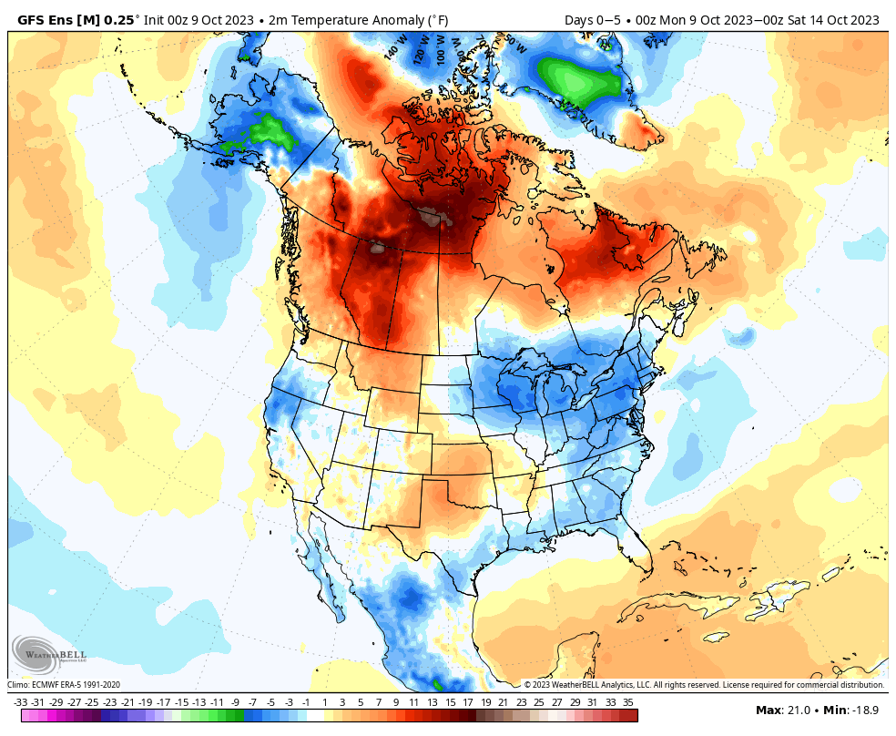
We’re opening the work week with a few scattered clouds and temperatures around the 40° mark. We’re in a pattern that will feature predominantly cooler to colder than normal temperatures over the next 10-14 days with a couple exceptions. We’ll call it a sea of cool with an island of warmth (Thursday and Friday). The relatively warmer temperatures come after the passage of a warm front and ahead of a cold front. The “in between” will feature another period of unsettled and stormy weather to close the work week.
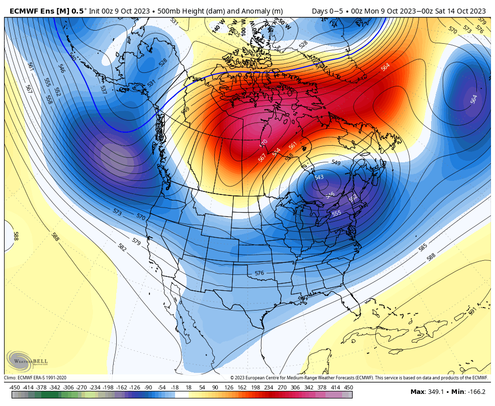
The overall upper air pattern shows that Hudson Bay blocking high and tendency for an eastern trough through the upcoming 2 week period. Another big cold shot will roll in here over the weekend and into the early Week 2 time period.
After a dry start to the week, rain chances will return late Wednesday and early Thursday (warm front) and again directly ahead of the cold front that will sweep through here Friday evening. Rainfall numbers with the passage of this system should check in between 0.25” and 0.75” for most of the region.
As we look ahead, a continued chilly pattern seems to be in store with additional storm dates that include:
10/19-10/20
10/23-10/24
Down the road, the strongly positive PNA and neutral to negative EPO should keep the chill flowing for the most part over the coming couple weeks. Eventually, these progressively colder shots will likely generate the 1st eastern flakes of the season, including for our friends in the beautiful high ground of those east TN and western NC mountains.
The highly advertised pattern shift is upon us. The downright balmy February and open to March will reverse in significant fashion in the coming days and weeks, and an active storm track is expected to accompany the chillier times.
Of course, this time of year, that doesn’t mean the active pattern will yield snow and winter storms. Ironically, this year, Mother Nature looks to be saving the best opportunity though of cashing in on wintry “fun and games” for the 1st month of meteorological spring- yes, in the face of the challenges that higher March sun angle presents. It’s important to note you need heavy precipitation rates and/ or wintry precipitation falling at night to get any sort of significant accumulation. At the very least, the next 2-3 weeks (at least) sure will make for frustrating times for those longing for true “stick and hold” spring.
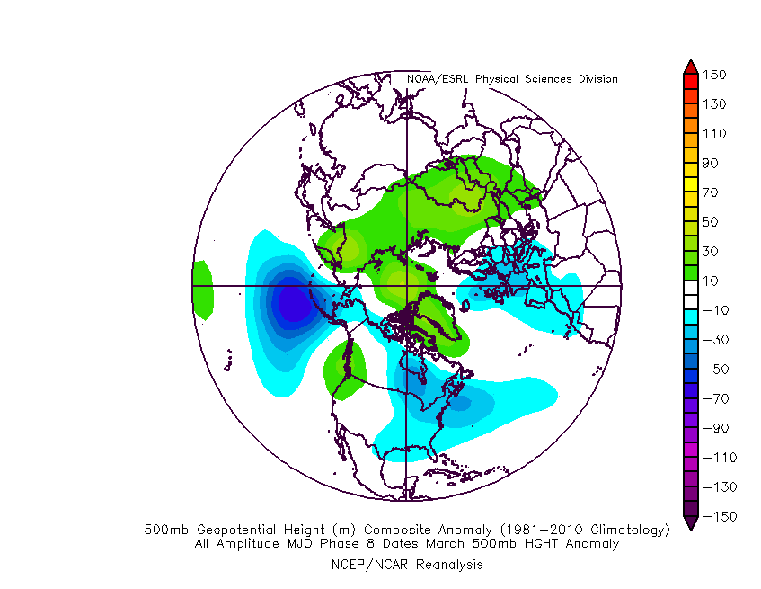
The Madden Julian Oscillation (MJO) will amplify right into the textbook cold phases over the next couple of weeks.
The composite March analogs for phases 8 and 1 show the trough taking up residence across our part of the country, including the increased likelihood of high latitude blocking. That blocking is important as it will not only serve to “bog the pattern down,” (meaning 1 or 2 storms should try and deepen as they roll towards the East Coast, as opposed to the energy flying by so quickly things can’t phase). The blocking also can be attributed to more of a persistent nature of below normal chill (obviously not in terms of “absolute” temperatures) compared to what we’ve really seen all winter.
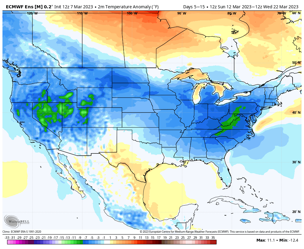
Ensemble guidance shows this plan coming together nicely:
As the high latitude blocking becomes established, forecast models will likely have to correct south a bit with the ‘mean’ storm track (compared to what is shown today). While I still don’t anticipate this doing much, if anything, with Friday’s system across immediate central Indiana, this does make for more interesting times early next week.
Today’s 12z European provides the most likely picture of what I feel will take place with the system in the Sunday-Monday time frame. The reason for such is that the upper level pattern should promote a healthier system (more organized than what the GFS shows) that bowls under the block and puts the Ohio Valley, eventually into the eastern chunk of the country (Mid Atlantic and Northeast) in play for snow and/ or a wintry mix. Once we get closer, I envision a system that may resemble what we’re looking at Thursday into Friday morning, just further south, thanks to the block becoming more established.
There will likely be additional storm systems that pose a similar wintry threat beyond this system as we look towards closing out March.
Looking back over the years, a return of winter is almost a given around these parts as March Madness looms, so I guess we shouldn’t be surprised…