Time For The Heavy Equipment: Localized Storm Totals Approach One Foot By The Time All Is Said And Done…

High resolution guidance started to show the snowier solutions earlier this evening and that trend has continued this evening. The consistency is great to see, but we also notice a couple of interesting elements “upstream” that will likely ultimately end up producing a memorable mid-December snow storm across central Indiana by the time all is said and done.

Before we talk specifics, here’s our updated snowfall forecast. Please note, this is expected total snowfall by daybreak Tuesday morning. We wouldn’t be shocked to hear of localized one foot amounts along the I-70 corridor.

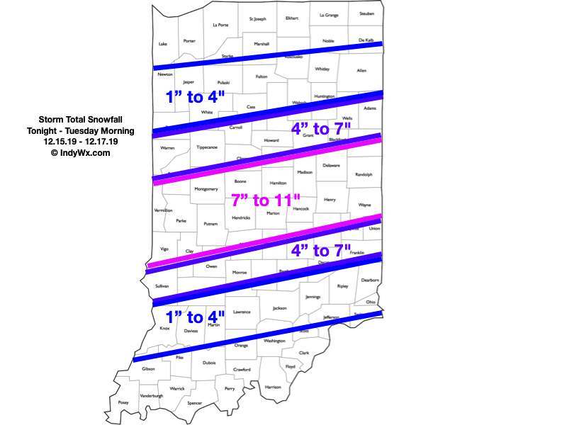
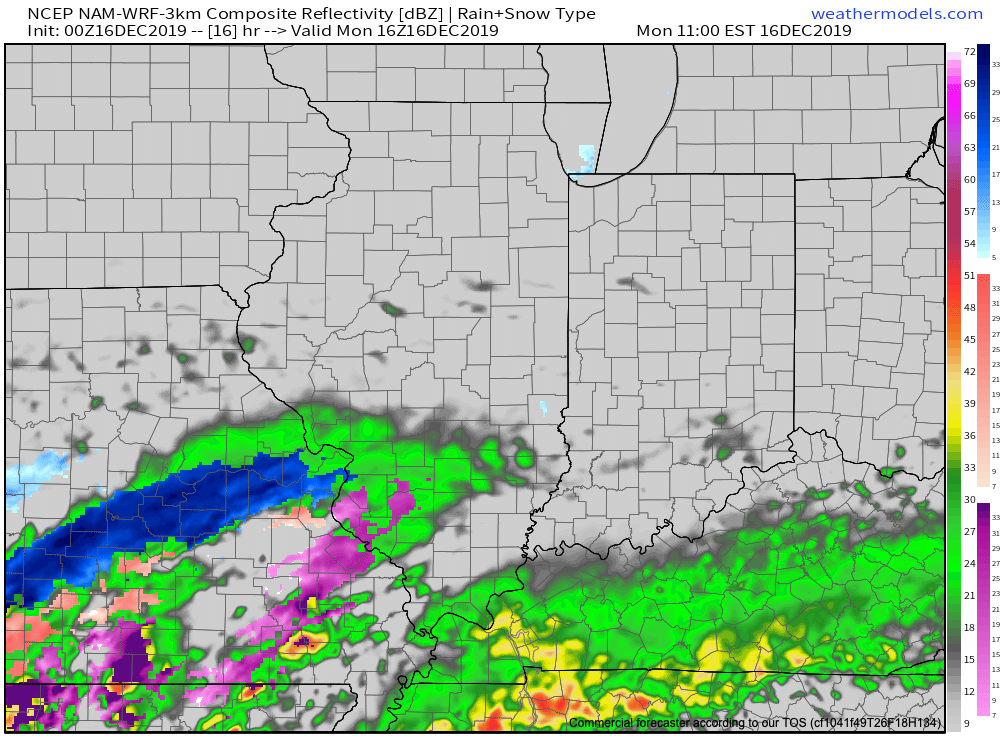
Periods of heavy snow will come to an end during the overnight. We think by 3a to 4a, most of the snow from “round 1″ will be to our east and we’ll be left with clean up duties before a Monday morning rush that will likely still be heavily impacted. By the time the 1st round is finished, most of the I-70 corridor will be shoveling and plowing away 4″ to 6” of wet snow.

We’ll then get into the expected lull in the action through a good chunk of the daytime Monday. That said, curious eyes will be focused in on south-central MO mid-to-late morning as precipitation blossoms in response to a strengthening surface wave that will move northeast out of the Ark-la-tex and into the TN Valley tomorrow night.

Precipitation will expand in coverage and intensity yet again tomorrow morning to our southwest.

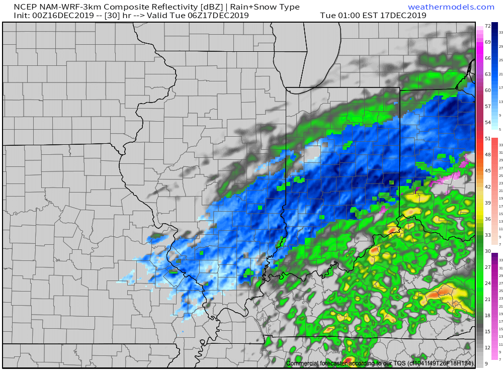
This will promote an expanding shield of moderate to heavy precipitation moving northeast and overspreading central Indiana by mid afternoon Monday. For us here across central Indiana, this will fall as snow.

Heavy snow will return to the I-70 corridor Monday afternoon.

If you don’t have to travel tomorrow, we’d recommend staying home and off the roads. While conditions will improve late morning into early afternoon, travel conditions will go downhill in significant fashion by 3p to 4p Monday across central Indiana- including the metro.

Periods of snow, heavy at times, will continue into the overnight before pushing off to the east before sunrise Tuesday. By that time, the heart of central Indiana will be cleaning up from a double digit and most memorable mid-December snow storm.

Periods of snow will continue into the overnight Monday.

We’ll be left with colder, but generally dry conditions Tuesday. Temperatures will remain below freezing through the day, but the majority of the region won’t be dealing with any additional snowfall after sunrise…

Gas up that snowblower! Next update will come early in the AM.

Something Doesn’t Jive…

I want to give a couple examples of significant conflicting signals- both short and long-term. The end result is a situation where long range, climate, and seasonal models are likely to have a very tough time not only in the medium to long range (2-4 week period), but thinking seasonally, as well (winter and next spring).

Short-term

To start, let’s look at the EPO. While strongly positive at present, both the EPS and GEFS pictured below take the EPO, or East Pacific Oscillation, negative in the coming couple of weeks.

A negative EPO pattern favors a trough across the eastern portion of the country, especially here in our neck of the woods, with western ridging.

All well and good, right? WRONG. The MJO, or Madden Julian Oscillation, is forecast to stall out into early October in Phase 1.

This time of year, Phase 1 argues strongly for eastern ridging and well above normal warmth while the western portion of the country can experience early wintry conditions.

Talk about contradiction! That’s what makes weather so fun and fascinating. Expect to be humbled often and to always learn! At various times of the year, select teleconnections can mean a lot more than other times of the year. For example, during the summer and fall, we lean heavily on the EPO, PNA, and MJO (if amplified). During the winter and spring, it’s important to take into account what the AO and NAO have to say. It’s important to know when to “pick and choose” when to use particular teleconnections… Furthermore, the various MJO phases (1-8) mean drastically different things at different times of the year. While lovers of chilly fall conditions have grown to hate an amplified Phase 1, they have to love it come winter (shown below). Just look at that difference!

Before jumping ahead to another example of “contradicting signals,” we’re confident the amplified MJO Phase 1 will carry the day through the short to medium range period. Note the strong agreement between the EPS and GEFS below with respect to temperature anomalies in the 6-10 day period.

With that said, there will be challenges within (the big difference as early as this weekend between the GFS and European operational data). A lot of that has to do with the “fight” between the EPO and MJO to take control.

As all of this unfolds across the East, the west will begin to cash in on early winter. Well below average cold and snowy conditions will begin to make headlines over the weekend into next week across not only the Rockies, but some of the low ground, as well. Should the MJO swing into Phase 2 (and I think it will towards mid-Oct), then watch out. We’ll be looking at a rather significant shift towards a much colder feel- and it’ll sting even more so with the late season heat over the better part of the next couple of weeks.

Flipping the page to winter (remember, our prelim. winter outlook will be posted later this week) and the contradiction continues. Upon looking at the current SST configuration, one could easily argue we’re talking about a La Nina winter unfolding ahead.

Meanwhile, the current SOI would suggest we’re in a moderate El Nino.

If you think this can’t wreck havoc even on the short-term forecast pattern, think again…

To close, while the conflicting data can create headaches at times, it’s more fascinating than ever trying to sift through the data and build our forecast(s). It’d be wise to expect more wild swings ahead- leave it to us to try and minimize the impacts of those swings in your day-to-day personal and professional lives. Accordingly, it’s also ultra-important to factor in additional items, such as solar and PDO into the equation for the upcoming winter.

Speaking of, without giving too much away, if I’m a winter weather fan (and I am), I wouldn’t worry in the least about the current warmth… 😉

Heavy Rain Ends As Snow This Evening…

A wet day is in store for central Indiana as a wave of low pressure moves along a stalled frontal boundary this afternoon. Once that low scoots by, the front will get a shove to the southeast and much drier weather will return as we go through the 2nd half of the weekend. The transition in between will be a combination of heavy rain eventually ending as wet snow this evening. Let’s time things out:

This morning’s initial wave of steady rain is now pushing into Ohio (as we write this just before 9a). Scattered showers are left behind.

That said, another wave of steady and, at times, heavy rain will return early this afternoon. A couple of thunderstorms are possible across southern Indiana.

Precipitation coverage will be widespread from noon until around 8p, including additional rainfall amounts over 1″ in many spots across central Indiana. Localized ponding and low-land flooding will be a good bet this afternoon into the evening hours.

As the area of low pressure scoots to our east, it’ll help pull the cold front south through central Indiana during the mid to late evening hours. Accordingly, rain will transition to a period of wet snow between 6p and 8p across central Indiana. More specific to Indianapolis, we think rain will switch to snow around 7p.

While snow won’t last a long time and temperatures will be above freezing as the snow is falling, briefly heavy intensity will likely result in a quick wet coating to around an inch in spots from central parts of the state, including east-central Indiana.

All precipitation will exit the state before midnight. While we could have a couple of scattered snow showers early Sunday morning, most of the day will be dry with increasing amounts of sunshine as the day progresses. It’ll be much colder with highs not making it out of the 30s.

Improving weather conditions will build in here through the early parts of the work week, along with moderating temperatures, thanks to high pressure. – Much more on the week ahead and longer range later today with our PM video update.