Category: Heavy Snow

Client Brief: Threat Of Impactful Wintry Event Increasing As Southeast Shift Continues…

Type: Impactful Wintry Weather

What: Accumulating snow and wind

When: Wednesday into Thursday morning

Temperatures: Middle 30s falling into the middle 20s by Wednesday night

Wind: North 15-25 MPH, increasing to 25-40 MPH Wednesday night and gusty

Blowing/ Drifting: Moderate to significant by Wednesday evening, continuing into Thursday morning

Pavement Impacts: Salting and plowing likely will be required

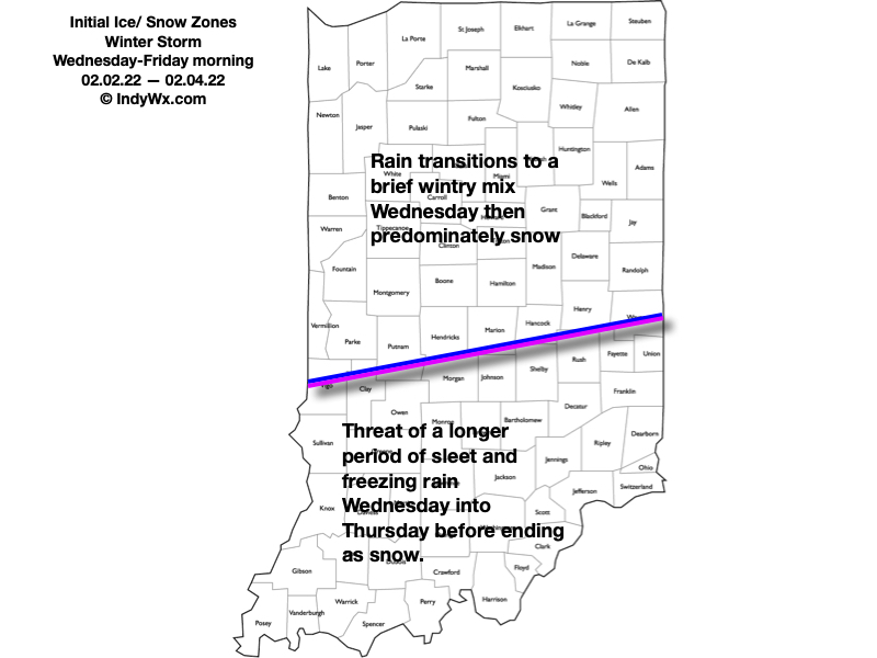
There has been a significant shift in the majority of model data today regarding the track of our midweek storm system. This has to do with a variety of elements, but most notably, the fact that the upper level energy at one time thought to come together to result in one primary storm during the first half of the work week, now looks to come in two parts: Monday into Tuesday, followed by a separate storm Wednesday into Thursday (this was what at one time was illustrated by the models a week+ ago). The debate now will continue for the next 24 hours around the deepening Storm #2 goes through, and this will have significant impacts on what central Indiana experiences in the Wednesday through Thursday time period. We think an initial wave of low pressure will organize along and just south of the Ohio River Tuesday night before tracking northeast and strengthening along the way into the eastern Great Lakes by Wednesday night. Should this, indeed, be the case, moisture would become widespread (after a relative “lull” Tuesday evening) across central Indiana Wednesday morning. With cold air funneling into the area by this time, the predominant precipitation type would fall as snow across central Indiana, including Indianapolis. Initially, this would be a wet type of snow before transitioning to a more powdery nature Wednesday evening.

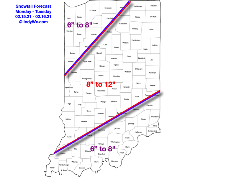
As the storm begins to deepen to our northeast, blowing and drifting snow would become a concern on west-east roadways Wednesday evening into Wednesday night as the pressure gradient increases. By this time frame, north and eventually northwest winds would gust over 30 MPH with temperatures falling through the 20s. “System” snow would come to an end Thursday morning, but lake effect will continue across the traditional primary Snowbelt of northern Indiana (please note the amounts above do not account for the additional lake effect snow that would fall for Laporte, St. Joseph, and Elkhart counties). Additional lighter snow is a good bet for all as we close the work week out Friday, courtesy of upper level energy diving southeast across the state.

One additional note: We’ve been receiving a lot of questions around whether or not the southeast shift will continue with the model updates tonight. While some slight additional southeast movement in the axis of heaviest snow is still possible, there will be a limit due to the interaction between the deepening surface wave and area of high pressure. We will continue to keep a close eye on the data overnight and update things accordingly if needed early tomorrow morning.

Confidence: Medium

Next Update: Tuesday morning

Permanent link to this article: https://indywx.com/client-brief-threat-of-impactful-wintry-event-increasing-as-southeast-shift-continues/

VIDEO: Short-Term Update On Tonight-Thursday…

You must be logged in to view this content. Click Here to become a member of IndyWX.com for full access.  Already a member of IndyWx.com All-Access?  Log-in here.

Permanent link to this article: https://indywx.com/video-short-term-update-on-tonight-thursday/

VIDEO: Heavy Snow Builds In This Afternoon; Arctic Front Hits Tomorrow…

You must be logged in to view this content. Click Here to become a member of IndyWX.com for full access.  Already a member of IndyWx.com All-Access?  Log-in here.

Permanent link to this article: https://indywx.com/video-heavy-snow-builds-in-this-afternoon-arctic-front-hits-tomorrow/

Client Brief: Time To Gas Up The Snow Plows…

Type: Impactful Wintry Weather

A winter storm will impact the Ohio Valley through the 2nd half of the work week.

What: Accumulating snow and sleet

When: Wednesday afternoon through Thursday evening

Temperatures: Lower 30s falling into the 10s by Thursday evening

Wind: Southeast 10-15 MPH Wednesday afternoon shifting to the north Wednesday night and northwest Thursday. Winds will gust 20-30 MPH Thursday evening.

Blowing/ Drifting: Light to moderate by Thursday evening

Pavement Impacts: Salting and plowing will be required

A busy 48 hours awaits for central Indiana as a winter storm begins to impact the region. Mid and high level cloudiness will continue spreading over the region this evening and give way to a lowering and thickening cloud deck overnight and Wednesday morning. This is all thanks to a developing area of low pressure over the Ark-la-tex region. This surface low will track northeast into the TN Valley Wednesday and into the central Appalachians Wednesday night into Thursday morning. Long time residents of the Hoosier state know this is a favorable track for impactful wintry weather across these parts and this will be no exception.

Moisture will begin to lift northeast during the day Wednesday and reach the I-70 corridor around or just after lunchtime. Across the southern half of Indiana, this moisture should primarily fall in the form of a cold rain (perhaps a bit of sleet initially as the precipitation moves in). However, further north, trouble will ensue. The air won’t only be colder at the surface, but the depth of cold air will be much deeper. This will result in precipitation that should predominantly fall in the form of a sleet-snow “concoction” along and north of the I-70 corridor where we think an axis of 2″ to 4″ of snow/ sleet will accumulate with this storm- including Indianapolis. Further north, less sleet is anticipated and will result in heavier snowfall totals. The northern Indianapolis ‘burbs and points north to include Lafayette, Kokomo, Logansport, Ft. Wayne, and Muncie can expect 4″ to 6″ of snow with this storm system. Most of that will fall Wednesday afternoon into Wednesday night with additional lighter snowfall accumulation occurring with “wrap around” snow showers and embedded squalls Thursday afternoon into evening. (The Indiana Snowbelt (you know who you are :-)) can expect additional heavier snow accumulation, courtesy of lake effect).

A brief, but potent shot of arctic air will pour into the region Thursday afternoon and set us up for widespread single digits by Friday morning, including the threat of some sub-zero temperatures where the heaviest snowpack is laid down.

Confidence: High

Next Update: Wednesday morning

Permanent link to this article: https://indywx.com/client-brief-time-to-gas-up-the-snow-plows/

VIDEO: Winter Storm Inbound For The Ohio Valley Wednesday Into Thursday; Shot Of Arctic Air Follows…

You must be logged in to view this content. Click Here to become a member of IndyWX.com for full access.  Already a member of IndyWx.com All-Access?  Log-in here.

Permanent link to this article: https://indywx.com/video-winter-storm-inbound-for-the-ohio-valley-wednesday-into-thursday-shot-of-arctic-air-follows/