Category: Heavy Rain

Sunday Afternoon Rambles…

Rain was plentiful over the region over the past 48 hours.  While widespread 2″ rainfall was common for all of central Indiana, the heaviest rainfall fell across southern and eastern Indiana.

Here are a couple of illustrations of the rainfall totals.  The first image is storm total rainfall from the past 24 hours. Note the heavy, 4″ type rains over southern and eastern Indiana. The second image is off the awesome Weatherbell model site and shows the heavy rainfall event over Indiana that unfolded on a bigger scale.  Needless to say, the short term drought concerns that we were dealing with August and September have been erased.

1379925_643932488960824_62568978_n


rtma_precip_48

Temperatures are running MUCH cooler over the region today and we also note a drier, more fall-like, air mass building into the region.  A couple of other items- it’s easy to see where the cold front is currently located (as of this post) as many in Ohio are still dealing with warm, humid conditions.  Additionally, the cold core upper level low remains to our west and will rotate over our region Monday.  This will lead to an unseasonably cool day with mostly cloudy skies and the potential of a scattered shower.

rtma_glus

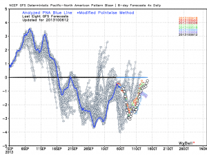
As we move forward, despite the cooler air to welcome in the new work week, we remain in a warmer than average pattern overall.  The PNA continues to dominate the pattern and until this goes positive, don’t look for any sort of sustained cool weather across the eastern US.

gfs_pna_bias


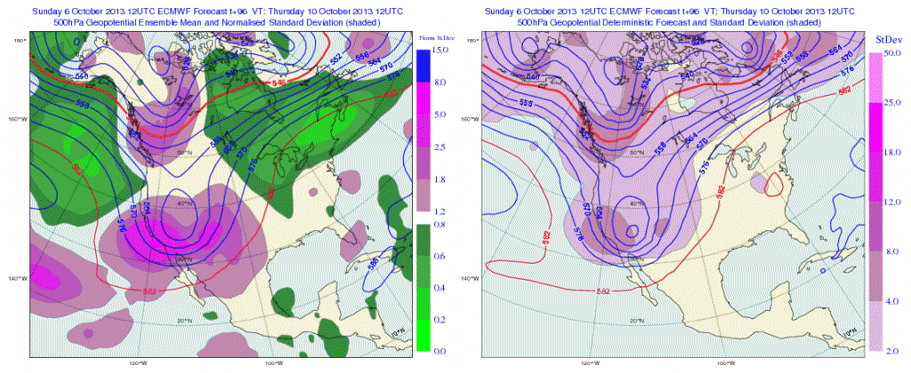
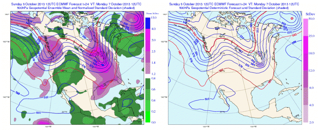
The European operational and ensemble show the current trough and associated cool air retreating and allowing a warmer southwesterly air flow to build in this week.

Monday

Geopotential32at32500hPa_North32America_24


Thursday

Geopotential32at32500hPa_North32America_96After a quiet time ahead (and much needed to dry out), our next significant storm system appears to arrive around mid month.  Both the GFS and European model are in agreement with this idea.  Does another potential significant rain maker and associated severe weather event lie ahead mid month?  Possibly.

Here’s a look at the upper air pattern out at Day 10 off the European model.  We note another significant storm system ejecting out into the Plains states, most likely after dumping another impressive early autumn snow on the central and northern Rockies.

ecm_z500_anom_noram_11

The GFS idea is something similar to that of the European, suggesting confidence is relatively high, at least from this distance.

gfs_z500_sig_noram_37

All of that said, we’re still in a “transient” pattern as the next big storm is shown crashing onshore along the west coast by both models.  We shouldn’t be surprised by a “transient” pattern this time of year. It’s October, after all- a month notorious for many swings on the thermometer.

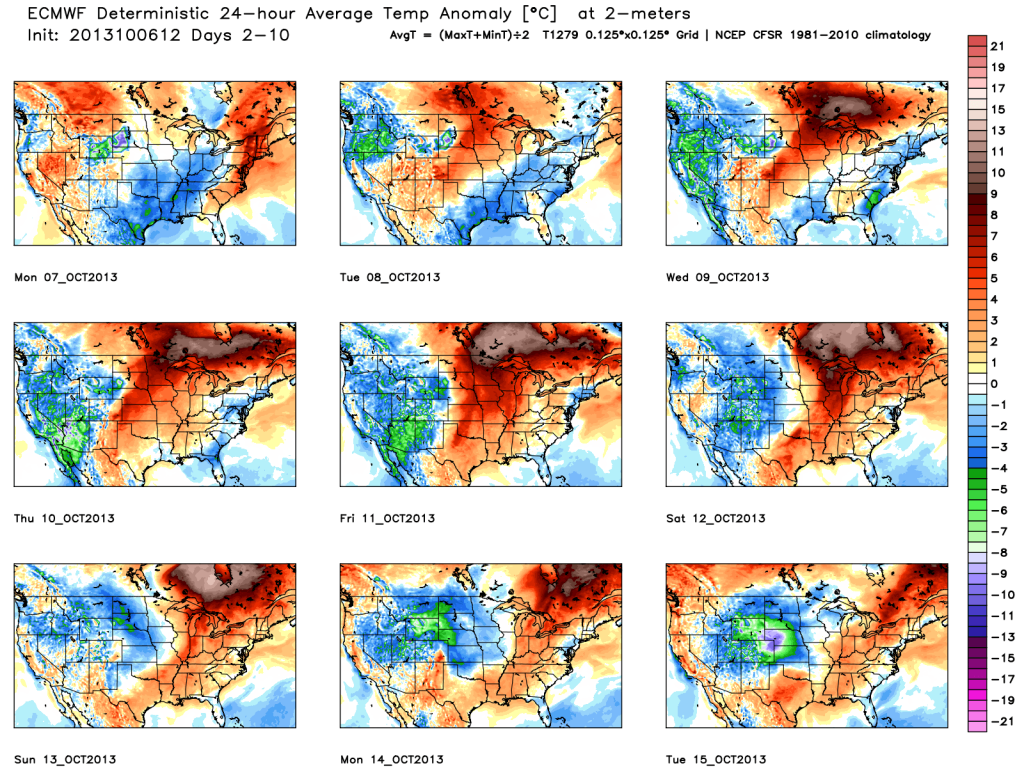
We’ll close with a look at the European’s temperatures anomalies over the course of the next 10 days.  Note the chill of early week erased with above normal warmth for the majority of the period. Also, pay attention to the unseasonable chill coming off the Rockies and into the Plains towards the end of the period below.  This is associated with the mid month storm.

tavg_anom_ecmwf_conus_1

Permanent link to this article: https://indywx.com/2013/10/06/sunday-afternoon-rambles/

Noisy Night Ahead; Longer Range Thoughts

A noisy night is ahead as the promised heavy rain event and strong to severe thunderstorms arrive in the city around, or just prior to 8pm.  A couple of rounds…

You must be logged in to view this content. Click Here to become a member of IndyWX.com for full access.  Already a member of IndyWx.com All-Access?  Log-in here.

Permanent link to this article: https://indywx.com/2013/10/05/noisy-night-ahead-longer-range-thoughts/

Quick Video Brief Discussing Rain & Severe Potential

http:/   Good Morning!  Here’s a quick video showing what the ECMWF and GFS see as far as the coming heavy rainfall event goes. Your full forecast is below. As…

You must be logged in to view this content. Click Here to become a member of IndyWX.com for full access.  Already a member of IndyWx.com All-Access?  Log-in here.

Permanent link to this article: https://indywx.com/2013/10/05/quick-video-brief-discussing-rain-severe-potential/

Saturday Forecast: Stormy Weekend Unfolding

Updated 10.05.13 @ 6:32a

Zionsville, IN After a pleasant end to the work week (how about highs once again zooming into the 80s Friday?!), we begin to undergo major weather changes as we progress through the weekend.  Our hats are off to the European model for nailing this heavy rain threat days in advance. After a sub-par performance earlier this week with rainfall amounts, it’s making up for “lost time” and in quick fashion.

Status-weather-showers-day-iconSaturday: Mostly cloudy, showers and t-storms; 1.00″ 66/ 78

While we may muster a little sunshine during the daytime hours Saturday, we think most of the day is mostly cloudy, warm, and humid, with an increasing risk of scattered showers and thunderstorms. We bracket the evening and overnight as the best time period for significant thunderstorms, including a severe thunderstorm. We anticipate damaging straight line winds as the primary focus for severe weather, but a quick spin-up tornado or two is possible. Severe weather is dangerous any time of the day, but particularly dangerous at night.  Be sure to keep tuned to local media and make sure to have your weather radio on alert mode. Another item of concern? The heavy rainfall threat. Most of central Indiana should check in with 1″, or more, of rainfall by the end of the day.

Status-weather-storm-night-iconSunday: Thunderstorms; 1.25″ 51/ 66

The cold front will slow to a crawl as it progresses through the state and as a result, we look for heavy rain and embedded thunder continuing Sunday, especially during the morning and early afternoon. Rain will end from west to east as we progress through the afternoon hours. Heavy rainfall is likely for the entire region, but especially for the eastern and southeastern portions of the state. Temperatures will begin to fall as we go through the afternoon.

Status-weather-showers-scattered-iconMonday: Mostly cloudy, showers; 0.10″ 50/ 59

An upper level low will remain overhead Monday creating a much cooler day along with considerable cloudiness and scattered showers. Highs likely won’t make it out of the 50s for many across central Indiana.

Status-weather-showers-day-iconTuesday: Partly to mostly cloudy, small shower chance; 0.10″ 45/ 62

Weather conditions will begin to improve as we move into Tuesday. We should add a little more sunshine to the mix and rain chances will diminish.  An isolated shower is possible, but many communities will remain rain-free Tuesday.

Status-weather-clear-iconWednesday through Friday: Mostly sunny; lower to middle 40s/ lower to middle 70s

We’ll enjoy dry conditions with lots of sunshine and moderating temperatures as we progress through the back half of next week.

Permanent link to this article: https://indywx.com/2013/10/04/saturday-forecast-stormy-weekend-unfolding/

Quick Afternoon Video Update

Your complete full, updated, forecast will be online later this evening.  Here’s a look at the 12z model data….coming more in line with what the European model has been saying…

You must be logged in to view this content. Click Here to become a member of IndyWX.com for full access.  Already a member of IndyWx.com All-Access?  Log-in here.

Permanent link to this article: https://indywx.com/2013/10/04/quick-afternoon-video-update/

Monitoring Where The Heaviest Axis Of Rain Sets Up

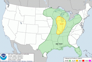
Good Friday morning!  Overnight model data is in and we continue to look things over from a total rainfall perspective, as well as any severe weather threat that exists Saturday evening. As of now, we anticipate the best chance of any kind of severe thunderstorms to occur Saturday evening/ night and the biggest threat appears to be from a damaging wind standpoint.  The latest severe weather outlook from the trusted Storm Prediction Center (SPC) places central and western Indiana under a Slight Risk of severe weather Saturday.

day2otlk_0600


The 12z NAM is hot off the press and suggests the heaviest rainfall threat is mostly east of Indianapolis proper.  There’s the chance rainfall amounts approach 2″ across far eastern Indiana.  We’ll continue to analyze the data as it comes in this afternoon and have a complete update posted later today.

nam_60hr_precip_east_21

Permanent link to this article: https://indywx.com/2013/10/04/monitoring-where-the-heaviest-axis-of-rain-sets-up/

Wednesday Forecast: Unseasonably Warm & Muggy

Updated 10.01.13 @ 9:44p Zionsville, IN Even after a late rally by the sun, October 2013 opened as the warmest in six years. We continue the warm, unseasonably muggy, and…

You must be logged in to view this content. Click Here to become a member of IndyWX.com for full access.  Already a member of IndyWx.com All-Access?  Log-in here.

Permanent link to this article: https://indywx.com/2013/10/01/wednesday-forecast-unseasonably-warm-muggy/

Friday Forecast: Showers & Storms Today; Fall-Like Weekend

Updated 09.19.13 @ 4:48p Zionsville, IN Officially, Indianapolis recorded over one and one half inches of rain Thursday (1.53″ as of 5pm), which was the most in a 24 hour…

You must be logged in to view this content. Click Here to become a member of IndyWX.com for full access.  Already a member of IndyWx.com All-Access?  Log-in here.

Permanent link to this article: https://indywx.com/2013/09/19/friday-forecast-showers-fall-like-weekend/

Flash Flood Threat For Parts Of The State

A flash flood threat exists across portions of southern Indiana tonight, extending north to include south-central Indiana. The image below shows where we think best chances of localized flooding exists…

You must be logged in to view this content. Click Here to become a member of IndyWX.com for full access.  Already a member of IndyWx.com All-Access?  Log-in here.

Permanent link to this article: https://indywx.com/2013/08/08/flash-flood-threat-for-parts-of-the-state/

Thursday afternoon short-term update

While everyone hasn’t gotten in on the heavy rain act, portions of central Indiana have received a “gully-washer” or two this afternoon. Scattered thunderstorms, some with heavy rain, continue into…

You must be logged in to view this content. Click Here to become a member of IndyWX.com for full access.  Already a member of IndyWx.com All-Access?  Log-in here.

Permanent link to this article: https://indywx.com/2013/08/08/thursday-afternoon-short-term-update/

IndyWx.com