Category: Heavy Rain
 Highlights:
- Strong to severe t-storm potential tonight-Tuesday morning
- More widespread rain and storms late week.
- Much drier and less humid this weekend.
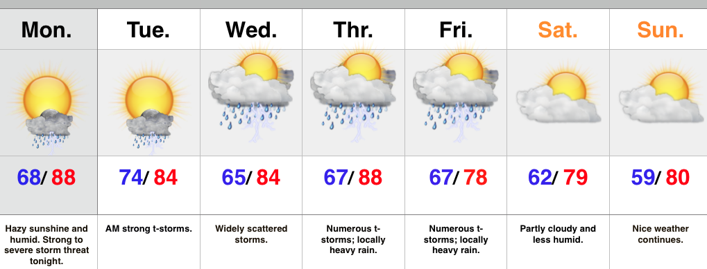
We’re off to a warm, humid, and hazy start to the day and most of your Monday will be a dry one. That said, all eyes will be to our NW as we eye thunderstorm complexes that will gain strength this afternoon and evening before tracking southeast. One storm complex will likely target the northern half of the state late tonight and on into the wee morning hours Tuesday. Damaging wind, vivid lightning, and localized flooding are of greatest concern.
Typical “splash and dash” storm coverage will be with us during the mid week period before a cold front delivers more widespread rain and storms for late week. Locally heavy rain will accompany this front. As of now, the timing couldn’t be better. We anticipate a much drier regime to blow into town behind the cold front, setting the stage for a beautiful weekend.
Upcoming 7-Day Rainfall Forecast: 2″ – 2.5″
Permanent link to this article: https://indywx.com/2015/06/22/strong-to-severe-storms-possible-tonight/
Monday and Tuesday will serve to offer up a continuation of storm chances- some of which may reach strong to severe levels. Most of both days will be dry, but…
You must be logged in to view this content. Click Here to become a member of IndyWX.com for full access. Already a member of IndyWx.com All-Access? Log-in here.
Permanent link to this article: https://indywx.com/2015/06/21/sunday-evening-rambles/
-
Filed under Bill, Flooding, Forecast Discussion, Heavy Rain, Rain, Severe Weather, Summer, T-storms, Tropics, Unseasonably Cool Weather, Weather Rambles
-
June 19, 2015
1.) A wet day is ahead for central & southern IN as the combination of a stalled front and Bill’s remnant moisture work in. Rain has already been heavy just…
You must be logged in to view this content. Click Here to become a member of IndyWX.com for full access. Already a member of IndyWx.com All-Access? Log-in here.
Permanent link to this article: https://indywx.com/2015/06/19/friday-morning-rambles-2/
-
Filed under Bill, Flooding, Forecast, Forecast Discussion, Forecast Models, Heavy Rain, Severe Weather, T-storms, Tropics, Weather Videos
-
June 18, 2015
You must be logged in to view this content. Click Here to become a member of IndyWX.com for full access. Already a member of IndyWx.com All-Access? Log-in here.
Permanent link to this article: https://indywx.com/2015/06/18/thursday-evening-video-update-3/
-
Filed under 7-Day Outlook, Bill, Forecast, Forecast Discussion, Heavy Rain, Rain, Severe Weather, Summer, Tropics, Unseasonably Warm
-
June 18, 2015
 Highlights:
- Afternoon showers and storms
- Watching Bill’s remnants
- Active pattern remains
The day is dawning with overcast skies and humid conditions. Dew points in the lower 70s coupled with lower 70 degree air temperatures have things feeling very tropical. Showers and thunderstorms will fire later this afternoon and a few of these could become strong to severe. With the moisture-laden air mass in place, torrential rainfall will remain likely with storms.
As we shift into Friday and Saturday all eyes will be on the remnant moisture of what once was Tropical Storm Bill. Latest model data focuses in on southern IN for the greatest threat of widespread heavy rain and potential flash flooding, including rainfall amounts of 3″ to 4″ in spots. We’ll continue to keep a close eye on the precise track of Bill’s remnants, but, as of now, folks downstate are at highest risk of flooding problems.
As we move into next week the active and stormy times continue. There are questions in regards to an expanding heat dome. Latest data has backed down dramatically on the potential heat next week. With the wet ground in place it’s hard to argue with that idea.
Upcoming 7-Day Rainfall Potential: 1.5″ – 2″ (locally heavier totals)
Permanent link to this article: https://indywx.com/2015/06/18/afternoon-storms-watching-bills-remnants/
June has gotten off to a warm start across the region. It’s been a wet month (to date) across northern regions of our #AGwx viewing area. Bill’s remnant moisture…
You must be logged in to view this content. Click Here to become a member of IndyWX.com for full access. Already a member of IndyWx.com All-Access? Log-in here.
Permanent link to this article: https://indywx.com/2015/06/17/ag-weather-report-6-17-15/
Rain and embedded thunder returns after a drier day, overall: Tuesday was a much drier day, overall, and sunshine built into central IN this afternoon to make for a very…
You must be logged in to view this content. Click Here to become a member of IndyWX.com for full access. Already a member of IndyWx.com All-Access? Log-in here.
Permanent link to this article: https://indywx.com/2015/06/16/tuesday-evening-catch-up/
-
Filed under Bill, Canadian Model, Forecast Discussion, Forecast Models, GFS, Heavy Rain, Rain, Summer, T-storms, Tropics
-
June 16, 2015
Tropical Storm Bill will make landfall later this morning along the central TX coast. Models handle the track of Bill differently in the days ahead, but we must continue…
You must be logged in to view this content. Click Here to become a member of IndyWX.com for full access. Already a member of IndyWx.com All-Access? Log-in here.
Permanent link to this article: https://indywx.com/2015/06/16/watching-bill/
-
Filed under 7-Day Outlook, Flooding, Forecast, Forecast Models, Heavy Rain, Rain, Severe Weather, Summer, T-storms, Tropics
-
June 15, 2015
 Highlights:
- Humid feel continues
- Strong to severe storms possible Tuesday
- Watching tropical remnants closely
We’re waking up to similar weather conditions that we dealt with to close the weekend- scattered heavy downpours and very humid. It certainly won’t rain the entire day, but scattered storms will bubble up again as we progress into the afternoon and evening. With the humid air mass locked in, any shower or storm that develops will produce torrential downpours.
A frontal boundary will slip into the region tomorrow and provide enough lift to present a strong to severe thunderstorm threat Tuesday. We’ll continue to keep a close eye on things. This front will stall out near the area and serve as a focal point for thunderstorm development through the upcoming few days.
The tropics continue to be of interest later this week, but we stress that forecast models are really struggling with handling the details. Solutions range from a flood threat presented by the European and Canadian; however the GFS would suggest the tropical remnants don’t get involved in our pattern. We’re leaning more towards the Euro/ Canadian blend as of now as we feel the SE ridge will help steer the tropical remnants northeast into the Ohio Valley late week (timing may have to be find tuned as we draw closer). Again, stay tuned.
Upcoming 7-Day Rainfall Forecast: 2″ – 3″ (locally heavier totals)
Permanent link to this article: https://indywx.com/2015/06/15/humid-stormy-times-continue-watching-the-tropics/
-
Filed under CFSv2, Flooding, Forecast Discussion, Forecast Models, Heavy Rain, Rain, Severe Weather, Summer, T-storms, Tropics
-
June 14, 2015
Today is the beginning of several active days around these parts. Over the course of the next few days severe weather and heavy rainfall will keep us on our toes…
You must be logged in to view this content. Click Here to become a member of IndyWX.com for full access. Already a member of IndyWx.com All-Access? Log-in here.
Permanent link to this article: https://indywx.com/2015/06/14/busy-times-in-the-forecast-office/


