You must be logged in to view this content. Click Here to become a member of IndyWX.com for full access. Already a member of IndyWx.com All-Access? Log-in here.
Category: Heavy Rain
Permanent link to this article: https://indywx.com/2017/07/25/video-stormy-weather-unfolds-late-wednesday-night-early-fall-like-weather-this-weekend/
Jul 22
VIDEO: Oppressive Feel Gives Way To Strong Storms…
You must be logged in to view this content. Click Here to become a member of IndyWX.com for full access. Already a member of IndyWx.com All-Access? Log-in here.
Permanent link to this article: https://indywx.com/2017/07/22/video-oppressive-feel-gives-way-to-strong-storms/
Jul 21
Periods Of Storms Interrupt An Otherwise Hot, Humid Regime…
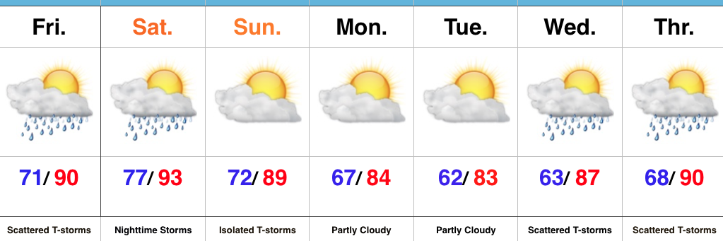 Highlights:
- Periods of storms
- Heat and humidity makes things uncomfortable
- Drier early next week
Mother Nature Calls…Many awoke early this morning as a complex of thunderstorms rumbled southeast into central Indiana. Some local rain gauges are already registering 2″+ across the region. Eventually, we think clouds will thin enough later today to allow temperatures to zoom close to 90°. Factor in the moisture-rich nature of our air mass and heat indices will approach 105° later this afternoon.
We’ll keep mention of scattered storms this evening and while most of the daytime Saturday looks dry, we’ll have to keep a close eye on Saturday night as models try to deliver another round of storms into central Indiana. Ingredients will be in place for the potential of severe thunderstorms Saturday night, with damaging winds being the biggest concern from a severe perspective.
A frontal boundary will push south and we’ll finally begin to see humidity levels fall as we close the weekend and open next week. It’ll feel very refreshing during the Monday-Tuesday stretch.
Heat, humidity, and storm chances return by the middle of next week.
Upcoming 7-Day Precipitation Forecast:
- Snowfall: 0.00″
- Rainfall: 1″ – 3″
Permanent link to this article: https://indywx.com/2017/07/21/periods-of-storms-interrupt-an-otherwise-hot-humid-regime/
Jul 16
Afternoon And Evening Rumbles…
 Highlights:
- T-storms arrive this afternoon
- Heating up this week
- Stormy periods late-week
Pleasant Start; Stormy Finish…After we got rid of the low level clouds and fog Saturday, it turned out to be a gorgeous day! The balance of our Sunday will also be very pleasant, but a frontal boundary will push through the state this evening and will be sufficient enough to kick up a line of showers and thunderstorms that will impact central IN this afternoon and evening. One or two of the storms could reach severe levels (large hail and damaging wind).
As we look forward, the big weather story this week will be the increasingly hot and muggy feel by late-week. Factor in that highs will approach 90° the second half of the week, along with dew points exceeding 70° and the stage will be set for a truly “oppressive” feel. Prepare to sweat.
Along with the increasingly heat and humidity, we’ll also note an increase in overall coverage of showers and thunderstorms through the late-week stretch. Individual disturbances will create periods of more widespread storms and with such a moisture rich air mass in place, expect periods of locally heavy rainfall.
Upcoming 7-Day Precipitation Forecast:
- Snowfall: 0.00″
- Rainfall: 1.50″ – 2.50″
Permanent link to this article: https://indywx.com/2017/07/16/afternoon-and-evening-rumbles/
Jul 13
Another Stormy Day, But Relief Is Coming…
 Highlights:
- Storms increase in coverage and intensity this afternoon
- More refreshing air arrives for the weekend
- Quiet start to next week
Stormy Afternoon On Deck…A frontal boundary will slip into the state today and slowly push south over the next 24 hours, eventually making it out of the state Friday. The combination of this trigger (front) along with a genuinely “soupy” air mass (precipitable water values will be north of 2″ and dew points will remain in the low-mid 70s) will result in increasing storm coverage this afternoon into the evening hours. Some of the storms may become severe and it also won’t take much for flash flooding to develop where storms train. In some cases, these storms will dump rainfall rates of 2″-3″/ hour. From a severe stand point, we’re most concerned for the potential of damaging straight line winds.
Thankfully, we’ll clear things out in time for the upcoming weekend. With the exception of a few morning thunderstorms downstate Friday, the trend will be a drier one and that will continue into Saturday. Along with the drier air, we’ll also note slightly cooler temperatures. It’ll feel much more refreshing than the past couple days.
A weak reinforcing cold front will sweep through the state Sunday evening and this boundary could kick-up a scattered thunderstorm or two Sunday afternoon-evening before we return to dry times Monday and Tuesday. Moisture (and heat) will return by the middle of next week.
Upcoming 7-Day Precipitation Forecast:
- Snowfall: 0.00″
- Rainfall: 1″-2″ (locally heavier totals)
Permanent link to this article: https://indywx.com/2017/07/13/another-stormy-day-but-relief-is-coming/
Jul 11
Another Stormy Day…
 Highlights:
- Tuesday and Thursday appear to be the stormiest days
- Drier trend to close the week; open the weekend
- Humid air gives way to a more refreshing feel
Stormy Periods…Storms are building across west-central Indiana this morning and these will settle into the city, itself, as the rush hour nears. This is only the beginning of multiple rounds of thunderstorms that will ride in a northwest to southeast fashion across central Indiana today. With dew points in the lower and middle 70s and precipitable water values exceeding 2″, additional flash flooding will result today for some communities where storms “train” over the same areas. A couple of strong-to-severe storms are also possible this afternoon with large hail and damaging straight line winds the biggest concern.
While we can’t rule out a passing storm Wednesday, overall storm coverage should be significantly reduced tomorrow as we get in on bit of a breather before another active time of things Thursday.
A surface front will settle south Friday. Best thunderstorm chances should occur during the front half of the day before a drier regime builds in from the north Friday evening and into Saturday. Temperatures will cool slightly, but we’ll really be able to notice a dramatic reduction in the humidity.
Sunday should be mostly dry, but we note a weak secondary boundary that will pass late in the day. This may be just enough to kick up a shower or thunderstorm Sunday afternoon or evening.
Upcoming 7-Day Precipitation Forecast:
- Snowfall: 0.00″
- Rainfall: 2″-3″ (locally heavier amounts)
Permanent link to this article: https://indywx.com/2017/07/11/another-stormy-day/
Jul 10
Active Times This Week…
The overall set-up this week will include a northwest flow aloft with multiple disturbances riding southeast out of the upper Mid West into the Ohio Valley. Each disturbance will aid in helping ignite more widespread rain and thunderstorms. The first couple waves of rain and thunderstorms look to impact central Indiana late morning into the early afternoon before the potential of additional thunderstorms late evening into the overnight. Some of the storms may become severe, including damaging winds.
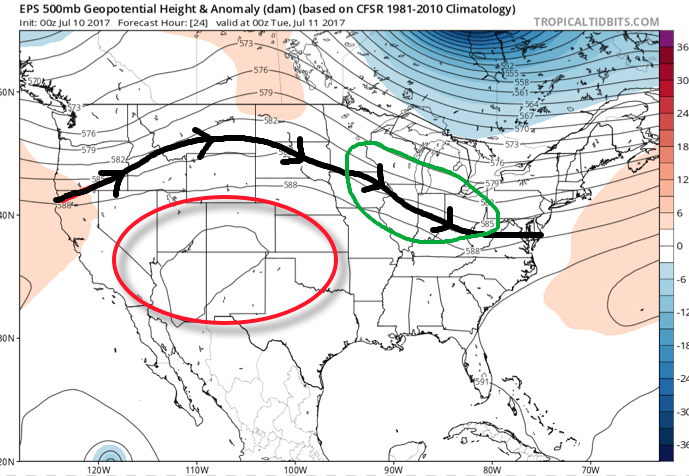 A quick step outside this morning will tell the story on just how different it feels. Gone is the refreshing air mass we enjoyed over the weekend and in return we’ve transitioned to an oppressive, tropical feel. Dew points will remain in the 70s through the majority of the work week and precipitable water values will reach 2″+ at times. With such a moisture laden air mass in place, flash flooding will likely result for some communities as the storms continue to track over the same areas this week.
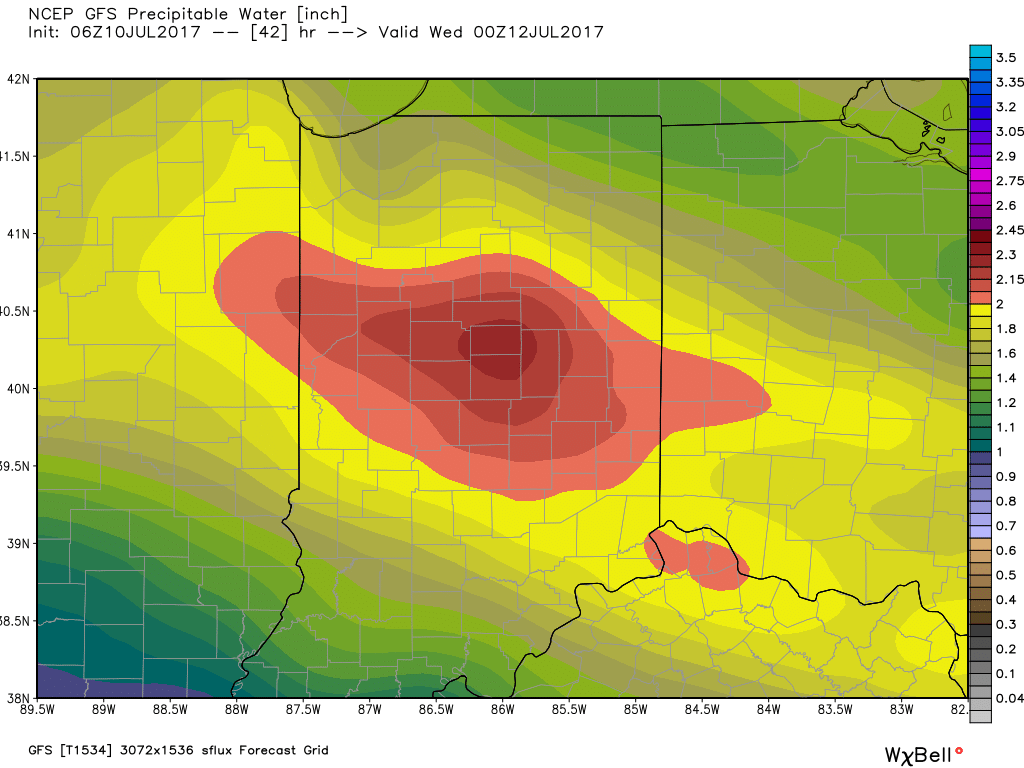 Additional waves of thunderstorms will impact the region through mid-and-late week before we advect some drier air into the state Friday evening into the weekend. Despite the lower dew points and cooler air, we still can’t rule out a shower or thunderstorm this weekend as a secondary front settles south.
When we total things up in the rainfall department through Saturday, widespread 2″-3″ can be expected, however, as mentioned, where storms “train,” much higher totals of 3″-6″+ will be a good bet.
Permanent link to this article: https://indywx.com/2017/07/10/active-times-this-week/
Jul 09
Heavy Rain; Strong Storms This Week…
 Highlights:
- Beautiful Sunday
- Multiple rounds of heavy rain and storms through the work week
- Cooler next weekend
Gearing Up For Busy Times…We’ll wrap the weekend up on a pleasant note with plentiful sunshine and low humidity. Enjoy it as active times loom…
We’ll begin to notice an increase in humidity as early as tonight and there’s a chance some of our far western counties could get in on a shower or thunderstorm this evening into the nighttime. Better coverage of showers and thunderstorms will come in waves beginning Monday and continuing through the majority of the work week. Individual disturbances moving southeast will have ample energy and moisture to work with and it won’t take much for storms to become severe in this kind of set-up. Dew points will reach “oppressive” levels Monday into Tuesday (70°+) and precipitable water values will exceed 2″ at times. Accordingly, where storms “train” there’s the potential of 3″-6″ of rain by week’s end.
While we can’t shut off rain and storm chances, we can introduce cooler and drier air working in here by the weekend. Despite the drier, more refreshing feel, an active northwest flow will remain and a secondary cold front may sweep through the state Saturday, sparking additional showers and storms.
Upcoming 7-Day Precipitation Forecast:
- Snowfall: 0.00″
- Rainfall: 2″-3″ (locally heavier amounts)
Permanent link to this article: https://indywx.com/2017/07/09/heavy-rain-strong-storms-this-week/
Jul 08
Pleasant Weekend Gives Way To A Stormy Week Ahead…
It was a stormy Friday across central Indiana, including hail, damaging winds, and localized flash flooding. Thankfully, as we open the weekend, weather conditions are much more pleasant. The surface front that helped trigger the bumpy close to the work week has pushed south and is allowing a much more pleasant (much drier and slightly cooler) air mass to ooze into the region. With the exception of patchy fog across southern Indiana, skies are mostly sunny.
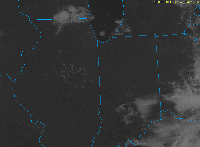
Patchy fog will burn off by 10a across southern Indiana.
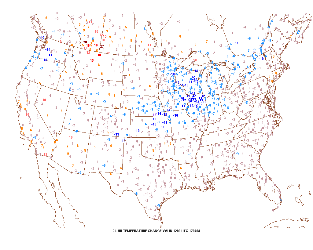
A cooler and less humid feel is greeting us out the door this morning.
Pleasant weather will remain through the majority of Sunday, but we’ll begin to notice an uptick in humidity late in the day. This is a harbinger of things to come as a true tropical feel lifts back north. Factor in the increasing moisture levels (it’ll feel oppressive by mid-week) with increasing amounts of energy and instability and big storms will likely result.
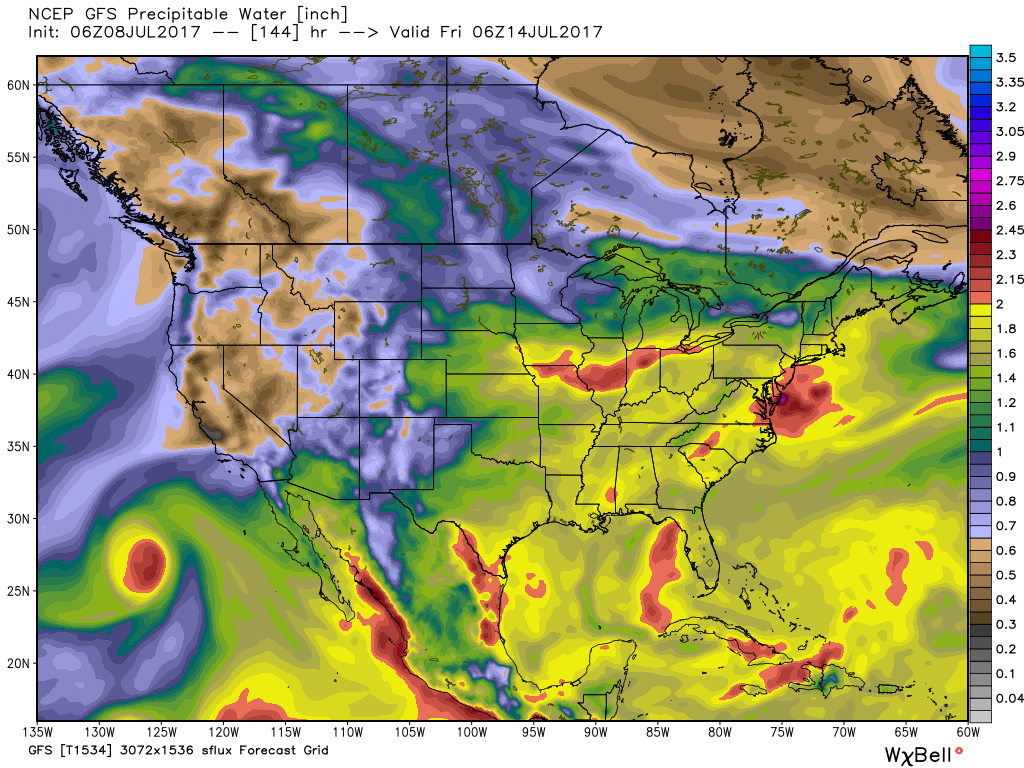
A moisture-rich air mass will engulf the region much of the upcoming work week.
The core of the heat will be centered over the western half of the country next week and with a northwest flow aloft, we’ll have to remain on guard for individual disturbances tracking southeast into the Mid West and Ohio Valley. These will help trigger more widespread storm coverage from time-to-time through the week. Similar to the storms yesterday, large hail, damaging winds, and flash flooding are the biggest concerns with these storm complexes. 7-day rainfall totals through late-week will feature widespread 2″-3″ across central Indiana, including locally heavier amounts of 3″-6″ in spots where storms train. We’ll have to sure-up specific storm timing as we get closer.
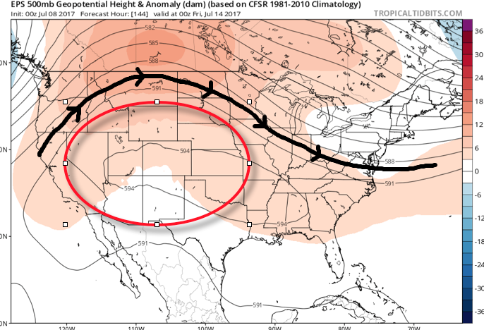
As we look ahead, timing, once again, may be our friend, as modeling currently suggests a drier regime returns by next weekend.
Make it a great Saturday, friends! More later!
Permanent link to this article: https://indywx.com/2017/07/08/pleasant-weekend-gives-way-to-a-stormy-week-ahead/
Jul 07
VIDEO: Stormy Afternoon Ahead For Some; Active Pattern Remains…
You must be logged in to view this content. Click Here to become a member of IndyWX.com for full access. Already a member of IndyWx.com All-Access? Log-in here.
Permanent link to this article: https://indywx.com/2017/07/07/video-stormy-afternoon-ahead-for-some-active-pattern-remains/
