You must be logged in to view this content. Click Here to become a member of IndyWX.com for full access. Already a member of IndyWx.com All-Access? Log-in here.
Category: Heavy Rain
Permanent link to this article: https://indywx.com/2020/03/19/video-severe-threat-increases-overnight-long-range-look-into-early-april/
Mar 18
Wednesday Morning Rambles: Midweek Storms, MJO Impacts On Late March Pattern…
I. The morning is off to a quiet, chilly start, but clouds will lower and thicken through the morning and rain will soon follow. Periods of moderate to heavy rain can be expected this afternoon into the early evening hours, including widespread 0.50″ to 1″ with a few locally heavier amounts.
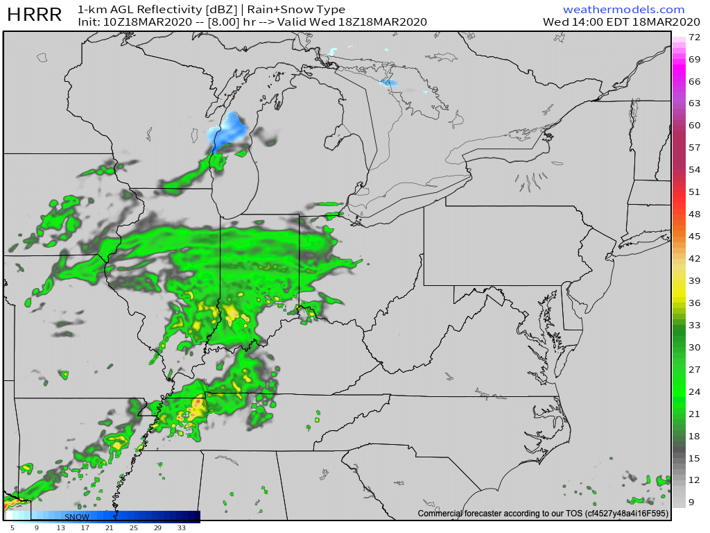
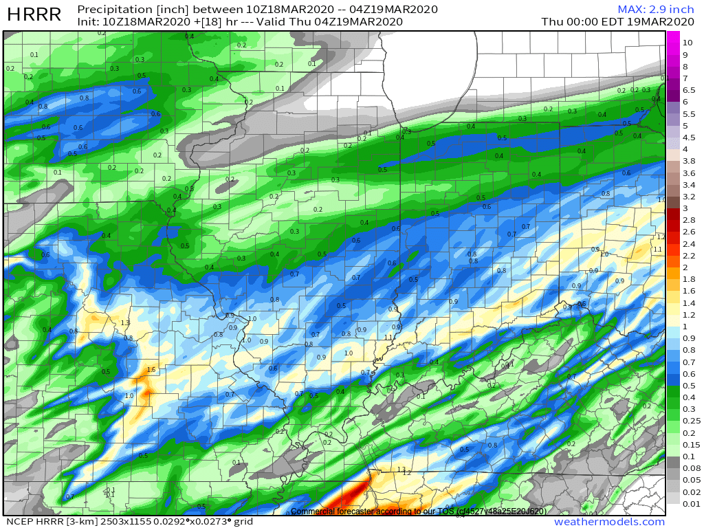
II. A changeable weather day is on tap Thursday with a couple of rounds of storms expected- late morning and again during the evening and night. The initial round of storms will lift northeast across the state Thursday morning into early afternoon, courtesy of a warm front. Highs will flirt with 70° tomorrow afternoon once the storms move out.
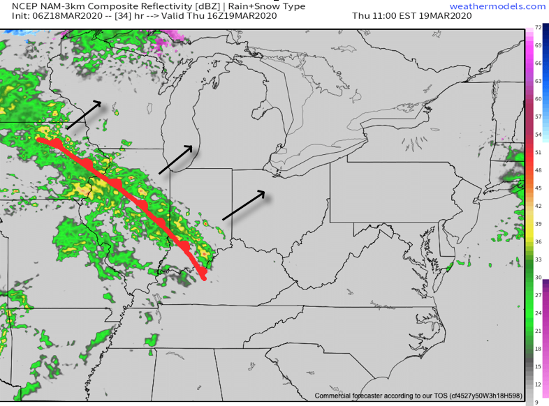
A cold front will then sweep through the region during the overnight. Additional storms (some potentially strong to severe) will take place as the front moves through the region.
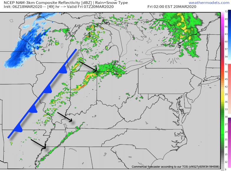

III. We’ll turn MUCH colder, but at least the sunshine will return as we move through the weekend. Lows in the 20s can be expected.
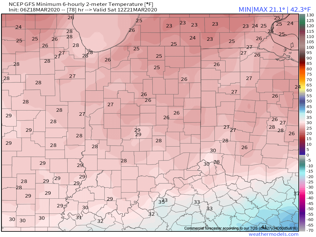
IV. Our next storm system looks to arrive Tuesday. From this distance, it appears this will be a potent system, including strong winds and heavy rain.

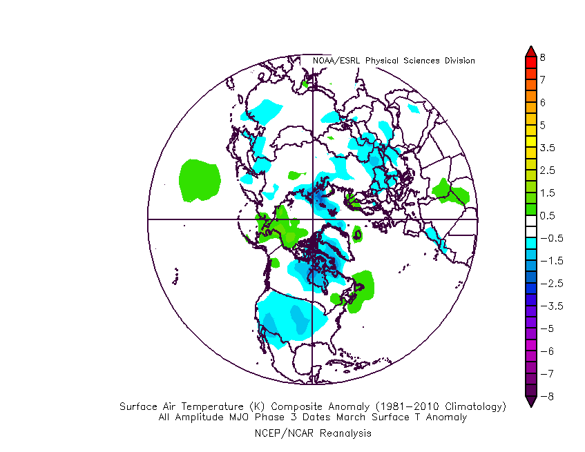
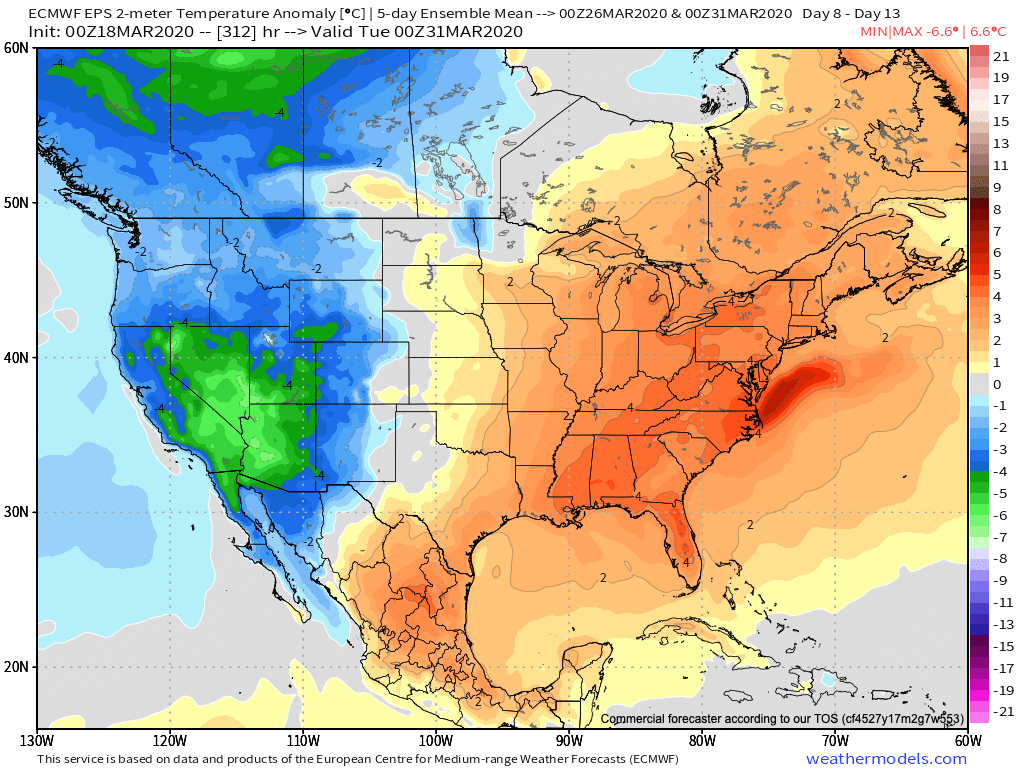
V. Longer term, we continue to watch the various players align. The MJO looks to amplify and rumble into Phase 3 by late March. The movement through Phases 1-2 can at least generate transient cold for our neck of the woods before Phase 3 favors the brunt of the cold across the West. Interestingly, this is what the latest European ensemble is also showing.
Permanent link to this article: https://indywx.com/2020/03/18/wednesday-morning-rambles-midweek-storms-mjo-impacts-on-late-march-pattern/
Mar 17
VIDEO: Enjoy Today’s Sun; Heavy Rain And Storms Build In For Midweek…
You must be logged in to view this content. Click Here to become a member of IndyWX.com for full access. Already a member of IndyWx.com All-Access? Log-in here.
Permanent link to this article: https://indywx.com/2020/03/17/video-enjoy-todays-sun-heavy-rain-and-storms-build-in-for-midweek/
Mar 15
Reviewing Saturday’s Snow And Looking Ahead To Another Busy Week…
Snow moved in during the predawn hours Saturday across north-central Indiana before encompassing more of central Indiana as the morning progressed. By mid-late morning, an incredibly intense band (2″+/ hour snowfall rates) set-up shop just north of Indianapolis. This was a byproduct of strong frontogenesis and dynamic cooling. Speaking of frontogenesis, if interested, here’s a fantastic article that can explain things further.
The end result was an “overachieving” wet snow event across north-central Indiana, including as far south as the northern Indianapolis ‘burbs. Sleet made it as far south as Greenwood before precipitation ended Saturday evening.
While the placement of our accumulating snow zone was a good one, amounts of 4″ to 5″ were reported throughout the southern half of this 1″ to 2″ forecast zone. This morning’s snowfall analysis shows the narrow, but moderate stripe of wet snow through the state:
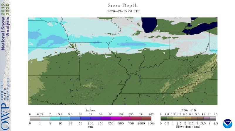
As the sun rises and clouds begin to depart, that snowpack is showing up on this morning’s visible satellite image.
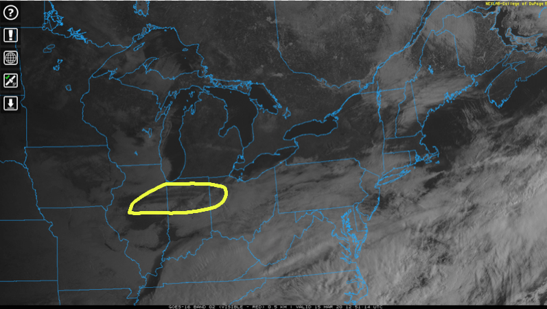
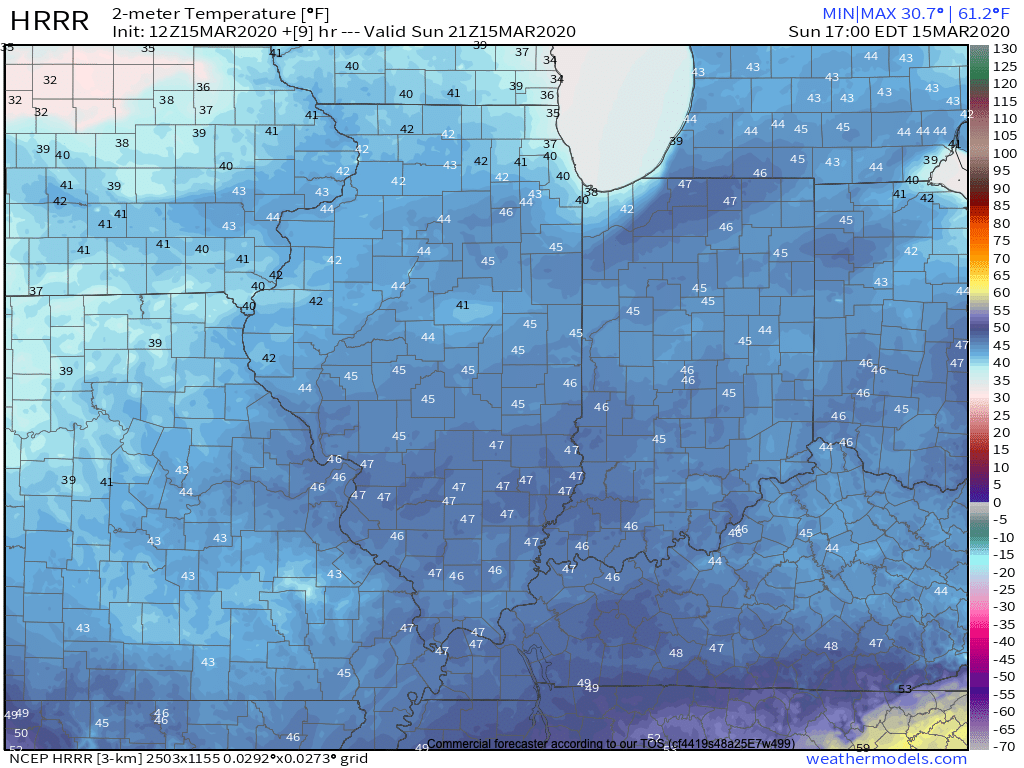
Officially, Indianapolis recorded 1.2″ Saturday, but as noted above, areas just north received as much as 4″ to 5″. With that increasing March sunshine today, snow will be all but a distant memory by later this afternoon. The average high for March 15th is in the lower 50s. Most will be 5° to 7° colder than that today with mid 40s for most.
As we turn the page and look ahead to what the remainder of the week will provide, a weak cold front will sweep through the Ohio Valley Monday night and Tuesday. This will be a moisture-starved frontal passage with only scattered, light showers anticipated tomorrow evening/ early Tuesday.

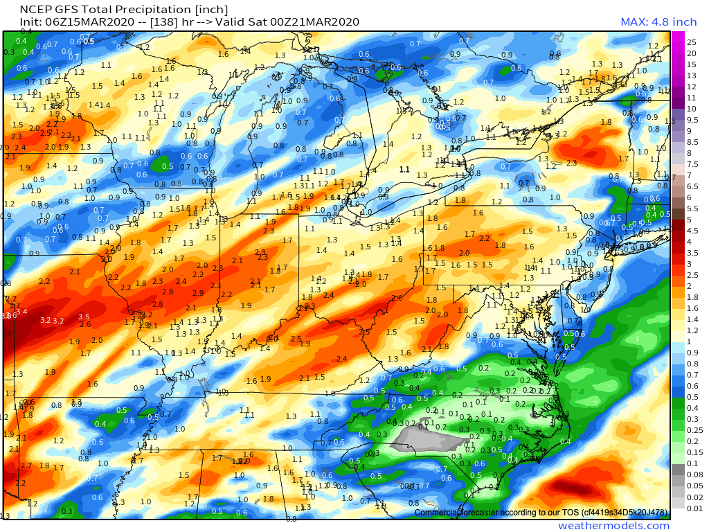
Things then turn much more unsettled as we head into the second half of the week. An initial wave of moisture will result in a period of moderate to heavy rain Wednesday. This will be followed up with a round of thunderstorms Thursday PM into early Friday morning. Some of these storms may reach strong to severe levels and will require us to continue to closely monitor things throughout the week.

Widespread 2″ to 2.5″+ rainfall amounts can be expected by the time everything winds down Friday afternoon. Most of that will fall Wednesday and Thursday night/ Friday morning.
We’ll dry out next weekend, but shift to a much colder time of things (lows in the 20s and highs in the 40s). This will come as a rather rude shock after highs Thursday flirt with the 65° to 70° mark.

Permanent link to this article: https://indywx.com/2020/03/15/reviewing-saturdays-snow-and-looking-ahead-to-another-busy-week/
Mar 14
VIDEO: Wet Snow Accumulates For Some Today; Severe Weather Set-Up Late Next Week…
You must be logged in to view this content. Click Here to become a member of IndyWX.com for full access. Already a member of IndyWx.com All-Access? Log-in here.
Permanent link to this article: https://indywx.com/2020/03/14/video-wet-snow-accumulates-for-some-today-severe-weather-set-up-late-next-week/
Mar 10
Very Active Pattern Looms For Mid And Late March…
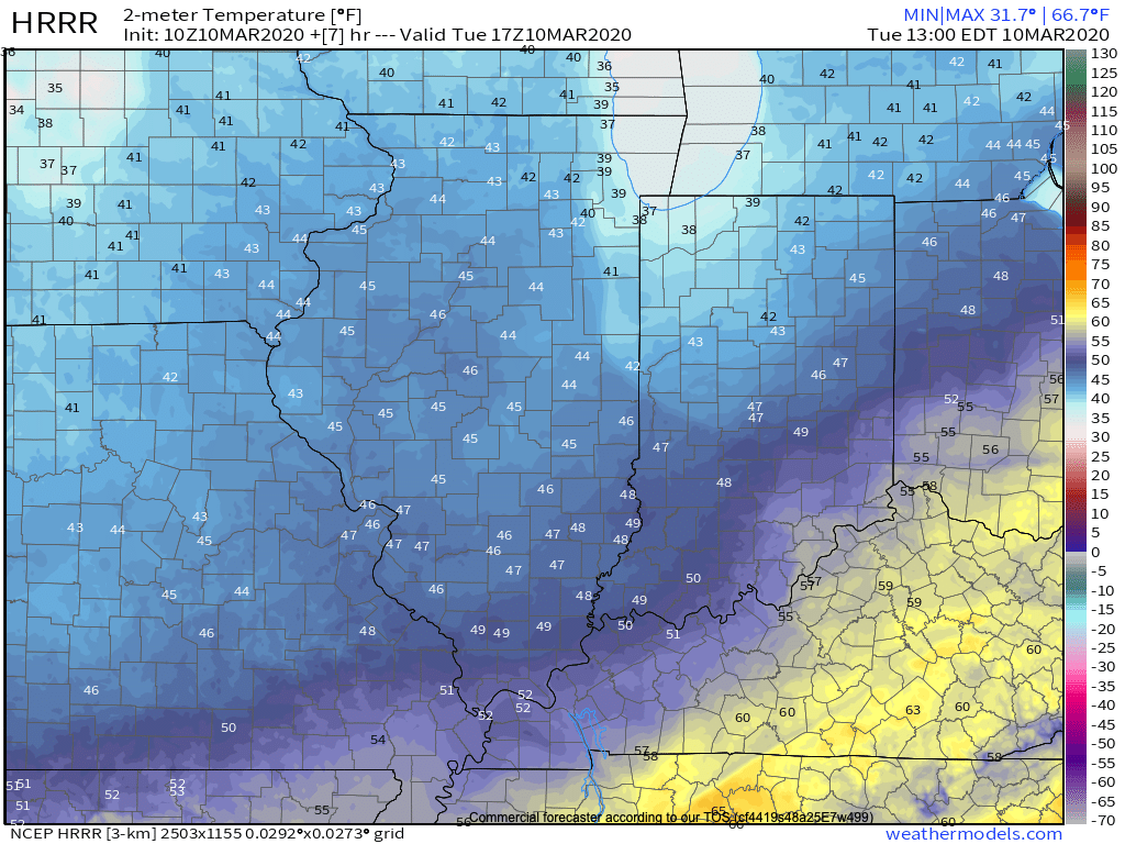
Before we get into the longer range weather pattern, rain this morning has been locally heavy in spots. Moving forward today, that rain will push east of the state and we’ll turn cooler. Temperatures will settle into the middle to upper 40s this afternoon across central Indiana.
Another couple of weak systems will scoot through the area as we push through the remainder of the work week. The first, tomorrow, will impact areas primarily to our north, however, a cold front will sweep through the state Thursday night and early Friday with light rain and an abrupt wind shift to the northwest. Rainfall amounts with the passage of this cold front should average only between a trace and 0.05″.
A third system will push east across the TN Valley Saturday into early Sunday. With marginally cold air in place across the Ohio Valley, precipitation may transition to wet snow or a mix of rain and snow along the I-70 corridor during this time frame. The northward extent of the precipitation shield is in question and we’ll have to keep a close eye on this system over the next couple of days.
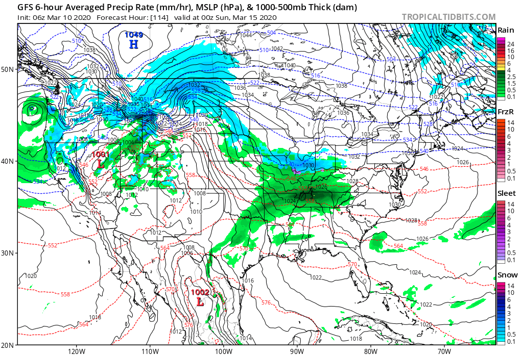
As we look longer term, a tight thermal gradient is expected to setup shop across our region. This will force a cold pattern across the west with eastern seaboard warmth. We’ll be in that “back and forth” battle zone of sorts, locally.
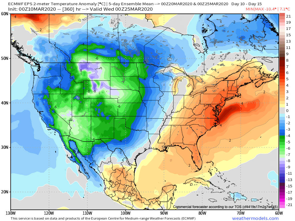
What this will also do is help assist in a hyper storm track through the MS River Valley and Ohio Valley. Above to well above average precipitation is expected during the middle and latter part of March across our region.

Unfortunately, local landscaping companies, turf management, farmers, and others with ag interests are likely to experience delays as we move through the 2nd half of March and into early April.
Permanent link to this article: https://indywx.com/2020/03/10/very-active-pattern-looms-for-mid-and-late-march/
Mar 06
Long Range Update: Active Mid-March Storm Track…
After a relatively quieter stretch of weather as of late, all signals ahead point towards an increasingly busy time of things over the upcoming couple of weeks. After (2) systems that will track in more of west-east fashion across the Ohio Valley during the 1st half of next week, the mean storm track will shift towards one that features low pressure systems moving out of the south-central Plains into the western Great Lakes thereafter.
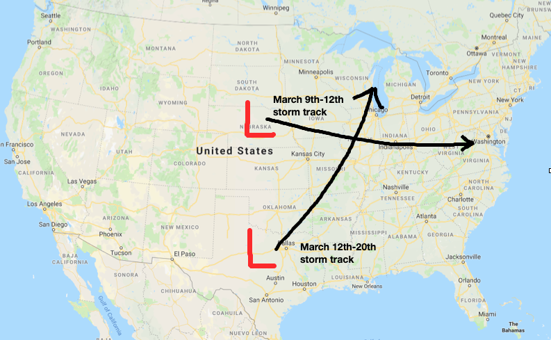
What this will do is replace a couple of systems (the mid-week one likely to still dish out wintry precipitation across the northern Ohio Valley/ Great Lakes region) during the first half of next week that feature cooler air and lighter rain with a more traditional spring flavor. The storm systems that impact our area during the mid-March time period will include heavier rain potential, along with warmer/ more humid air and the risk of stronger storms.
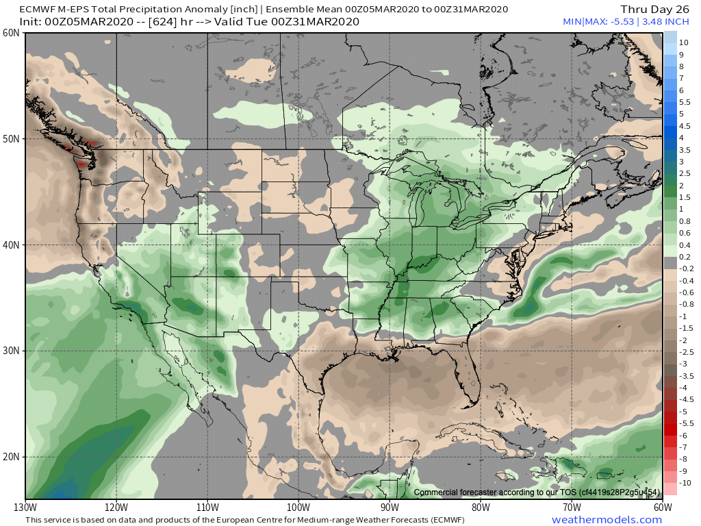
Just in the next 2 weeks, we count a total of (5) storm systems that will impact the region. In the face of what the latest JMA Weeklies were trying to suggest around drier conditions, it appears as if our wet March forecast will play out nicely.

Note the longer range computer model guidance from the GEFS and European Weeklies also see the wet anomalies greatest through an area that includes the Ohio Valley.

We’ll also have to begin paying attention to the potential of increased severe weather threats into the Ohio Valley with the expected mid-March storm track.
In the short-term, if you can deal with today’s snow and wintry feel, a gorgeous weekend is dialed up, including plentiful sunshine and quickly moderating temperatures (low 50s Saturday and low 60s Sunday).
More later!
Permanent link to this article: https://indywx.com/2020/03/06/long-range-update-active-mid-march-storm-track/
Feb 27
VIDEO: Additional Scattered Snow Showers/ Squalls Today Into Friday AM; Active Pattern Next Week…
An active weather pattern will remain in place. Not only will we have to watch for scattered snow squalls this evening (snow will be heavy enough to greatly reduce visibility…
You must be logged in to view this content. Click Here to become a member of IndyWX.com for full access. Already a member of IndyWx.com All-Access? Log-in here.
Permanent link to this article: https://indywx.com/2020/02/27/video-additional-scattered-snow-showers-squalls-today-into-friday-am-active-pattern-next-week/
Feb 26
VIDEO: Snow Increases In Coverage/ Intensity Late Morning Into The Afternoon; Active Pattern Over The Upcoming 10 Days…
You must be logged in to view this content. Click Here to become a member of IndyWX.com for full access. Already a member of IndyWx.com All-Access? Log-in here.
Permanent link to this article: https://indywx.com/2020/02/26/video-snow-increases-in-coverage-intensity-late-morning-into-the-afternoon-active-pattern-over-the-upcoming-10-days/
Feb 10
VIDEO: Analyzing Mid-Week Winter Storm Threat; MUCH Colder To Close The Week…
You must be logged in to view this content. Click Here to become a member of IndyWX.com for full access. Already a member of IndyWx.com All-Access? Log-in here.
Permanent link to this article: https://indywx.com/2020/02/10/video-analyzing-mid-week-winter-storm-threat-much-colder-to-close-the-week/
