Category: Heavy Rain
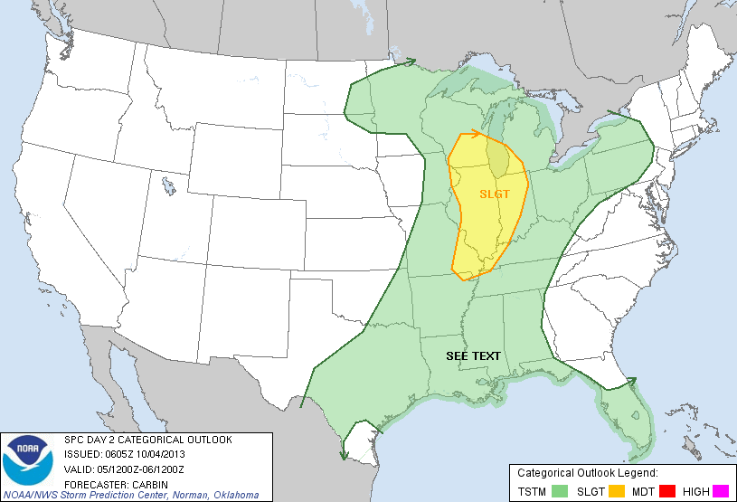
Good Friday morning! Overnight model data is in and we continue to look things over from a total rainfall perspective, as well as any severe weather threat that exists Saturday evening. As of now, we anticipate the best chance of any kind of severe thunderstorms to occur Saturday evening/ night and the biggest threat appears to be from a damaging wind standpoint. The latest severe weather outlook from the trusted Storm Prediction Center (SPC) places central and western Indiana under a Slight Risk of severe weather Saturday.
The 12z NAM is hot off the press and suggests the heaviest rainfall threat is mostly east of Indianapolis proper. There’s the chance rainfall amounts approach 2″ across far eastern Indiana. We’ll continue to analyze the data as it comes in this afternoon and have a complete update posted later today.

Permanent link to this article: https://indywx.com/monitoring-where-the-heaviest-axis-of-rain-sets-up/
Updated 10.01.13 @ 9:44p Zionsville, IN Even after a late rally by the sun, October 2013 opened as the warmest in six years. We continue the warm, unseasonably muggy, and…
You must be logged in to view this content. Click Here to become a member of IndyWX.com for full access. Already a member of IndyWx.com All-Access? Log-in here.
Permanent link to this article: https://indywx.com/wednesday-forecast-unseasonably-warm-muggy/
Updated 09.19.13 @ 4:48p Zionsville, IN Officially, Indianapolis recorded over one and one half inches of rain Thursday (1.53″ as of 5pm), which was the most in a 24 hour…
You must be logged in to view this content. Click Here to become a member of IndyWX.com for full access. Already a member of IndyWx.com All-Access? Log-in here.
Permanent link to this article: https://indywx.com/friday-forecast-showers-fall-like-weekend/
A flash flood threat exists across portions of southern Indiana tonight, extending north to include south-central Indiana. The image below shows where we think best chances of localized flooding exists…
You must be logged in to view this content. Click Here to become a member of IndyWX.com for full access. Already a member of IndyWx.com All-Access? Log-in here.
Permanent link to this article: https://indywx.com/flash-flood-threat-for-parts-of-the-state/
While everyone hasn’t gotten in on the heavy rain act, portions of central Indiana have received a “gully-washer” or two this afternoon. Scattered thunderstorms, some with heavy rain, continue into…
You must be logged in to view this content. Click Here to become a member of IndyWX.com for full access. Already a member of IndyWx.com All-Access? Log-in here.
Permanent link to this article: https://indywx.com/thursday-afternoon-short-term-update/