Category: Heavy Rain

Unsettled And Stormy; Turning MUCH Cooler!

Mon.

Tue.

Wed.

Thr.

Fri.

Sat.

Sun.

 Status-weather-showers-day-icon

 Status-weather-showers-day-icon

 Status-weather-storm-night-icon

 Status-weather-showers-scattered-icon

 Status-weather-showers-scattered-icon

 Status-weather-showers-day-icon

 Status-weather-showers-day-icon

63/ 82

66/ 77

52/ 60

44/ 56

42/ 55

37/ 60

38/ 60 

Light

Light

Moderate

Light

Light

Light

Light

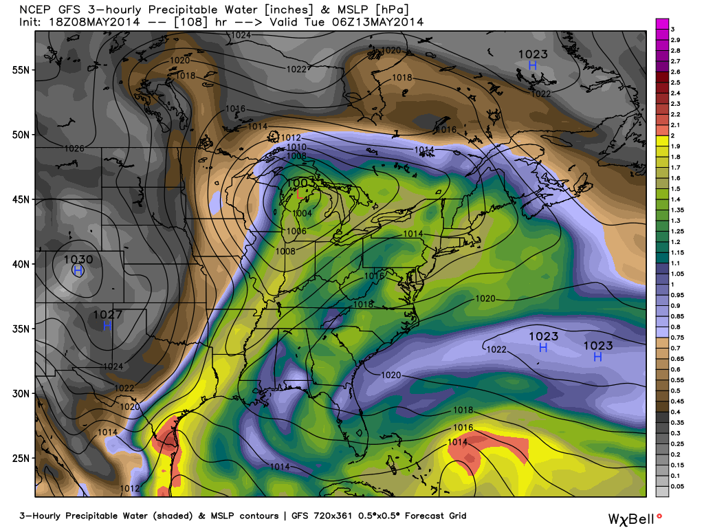
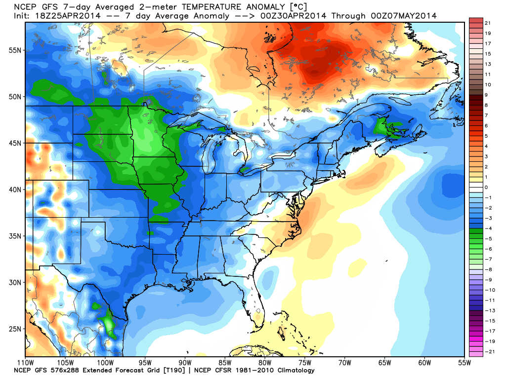
The new work week will feature a very stormy and unsettled weather pattern.  While everyone won’t get wet today, we do note the likely chance of afternoon thunderstorms bubbling up during the heating of the day.  Like Sunday, any of these storms could feature torrential rain and could quickly pulse to severe levels.  More widespread rain chances will arrive Tuesday into Wednesday in direct association with a cold front.  The long advertised cooler pattern will arrive behind this front and set up an unseasonably cool time of things to close out the second half of the week and head on into the weekend.  Rainfall totals this week will average an additional 1.25″ to 1.50″ with locally higher totals.  As for temperatures, we’ll go from well above seasonal levels today (8-10 deg. above normal) to well below seasonal levels by mid week (20 deg. below normal).

Forecast radar at 2:00p today, via the short-term high resolution HRRR forecast model.

Forecast radar at 2:00p today, via the short-term high resolution HRRR forecast model.

Permanent link to this article: https://indywx.com/unsettled-and-stormy-turning-much-cooler/

Smorgasbord Of Weather!

Posts this weekend will be a bit “off schedule” as I celebrate my brother’s graduation.  That said, posts will hit the site over the weekend and we’ll also keep you updated on our Twitter feed- @indywx.  A busy time of things lies ahead and a very active weather pattern will carry us into this time next week.  Let’s get into some of the details!

1.) (2) rounds of showers and thunderstorms will be likely Friday.  Weakening showers and embedded thunder will dissipate moving into central Indiana Friday morning.  That said, depending on the amount of clearing that takes place behind the first wave of showers and storms will go a long way into determining the severity of round two Friday evening.  The SPC (Storm Prediction Center) continues to highlight our area for a Slight Risk of severe weather (primary threats are large hail and damaging straight line winds) Friday evening.  We also note the latest high resolution NAM simulated radar shows potential strong to severe thunderstorms moving in tomorrow evening.

hires_ref_indy_24

2.) A second heavy rain and storm maker will arrive early next week. The Gulf of Mexico is open for business and suggests some locally heavy downpours are a good bet with both storms.  This isn’t bad news as it’s been dry as of late.  We’re now on day 9 without measurable precipitation and that will be changing in a big way over the upcoming 7 day period.  Widespread 2″-2.5″ rains are a good bet over the upcoming week, including some locally heavier totals.

gfs_pwat_mslp_east_37

The detailed video discussion below covers more on the severe chances, heavy rain threat, and a much cooler pattern ahead!

Permanent link to this article: https://indywx.com/smorgasbord-of-weather/

Summer-Like Today & Thursday; Storms By Friday.

Wed.

Thr.

Fri.

Sat.

Sun.

Mon.

Tue.

 Status-weather-clouds-icon

 Status-weather-clouds-icon

 Status-weather-storm-night-icon

 Status-weather-showers-day-icon

 Status-weather-showers-day-icon

 Status-weather-storm-night-icon

 Status-weather-storm-night-icon

58/ 86

63/ 87

62/ 69

60/ 75

60/ 81

64/ 77

46/ 64 

– – –

– – –

Moderate

Light

Light

Moderate

Moderate

The warmest air of the year so far will blow in to the region today and Thursday.  We forecast mid to upper 80s both days, alongside a strong southwest wind.  Things then will turn more active to close the work week with showers and thunderstorms Friday, including the slight risk of severe weather (large hail and damaging straight line winds are the early threats).  The cold front will essentially wash out over the area this weekend keeping unsettled weather around.  That said, it won’t rain the entire time Saturday and Sunday and we’ll enjoy more dry hours than wet hours.  A stronger cold front promises more heavy rain and a renewed severe threat early next week before a MUCH cooler push of air arrives late next week.

Video discussing today’s custom built IndyWx.com Forecast issued at 7:23am:


Permanent link to this article: https://indywx.com/summer-like-today-storms-by-friday/

Monday Night Severe Weather Update.

Good evening and welcome in to IndyWx.com!

We continue to closely monitor radar and satellite trends tonight and keep a close eye on severe developments to our west.  As the video discusses, the clouds and rain from earlier today have helped in a big way from at least limiting what today “could have been” from a severe perspective.

That’s not saying we’re signaling the all-clear by any stretch of the imagination, it’s just saying that the clouds and rain from earlier have helped to keep us from really destabilizing the local atmosphere and the clearing we’re seeing now may be too little too late in regards to widespread severe weather here.

All of that said, keep a close eye on local radar tonight and remain weather aware.  The dynamics at play could result in a thunderstorm turning severe rather rapidly tonight and we’ll continue to closely monitor.

Strong to potentially severe thunderstorms will impact central Indiana during the overnight period:

hrrr_ref_indy_9

The video below has more details:

Permanent link to this article: https://indywx.com/monday-night-severe-weather-update/

Nice Weekend Before A Prolonged Rainy/ Stormy Stretch…

A mostly dry and warm weekend is underway.  The Friday afternoon sunshine we enjoyed is a preview of what the majority of the weekend will provide.  We note the threat of a scattered shower or storm across northern portions of the state during the predawn hours Saturday and across central portions of the state (including Indianapolis) during the predawn hours Sunday. That said, in both cases, most will remain rain-free.

The big event is still slated for a late Sunday night arrival.  Low pressure will sit and spin across the Plains states Saturday into Sunday.  While we stay mostly dry, a major severe weather outbreak will likely unfold across this area during the day Saturday and again Sunday.

Better chances of rain and thunderstorms will arrive across central Indiana late Sunday night.  Some of these storms may be strong, but we think it’s more in the Monday and Tuesday time frame where we really need to be on our toes in regards to severe potential.  At this juncture, it appears as if all modes of severe weather will be in play across the region, including tornadoes, hail, and damaging straight line winds.  An enhanced risk of severe weather will lie across southern portions of the state.

The Days 4 and 5 severe weather outlook from the fine folks at the Storm Prediction Center (SPC) will likely be expanded north as we move forward.day48prob

Forecast radar from some of our high resolution model data suggests thunderstorms begin to rumble into the state as early as Sunday night.

hires_ref_indy_58

Eventually, this big spring storm will begin to weaken and turn into a large closed off upper level low pressure system. This promises a MUCH cooler stretch here mid to late next week along with continued unsettled conditions, with periods of showers and blustery northwest winds.  In fact, IND very well record measurable precipitation every day Sunday through next Saturday…

gfs_z500_sig_east_24

After a warm weekend and early week, note the colder air moving in to wrap up April and open May. Temperatures are moving in the wrong direction.  Highs by the mid to latter part of next week will only make it into the lower 50s some days.  The first week of May looks much cooler than average.

gfs_t2x_anom7_east_18


Permanent link to this article: https://indywx.com/nice-weekend-before-a-prolonged-rainy-stormy-stretch/