Category: Heavy Rain

Tuesday Night Update; Southern Indiana Under Gun For A Big Severe Weather Day Wednesday.

It’s been a bit of a frustrating afternoon as I’ve been trying to upload a video discussing our thoughts around tomorrow for a couple of hours….only to no avail.

photo-6


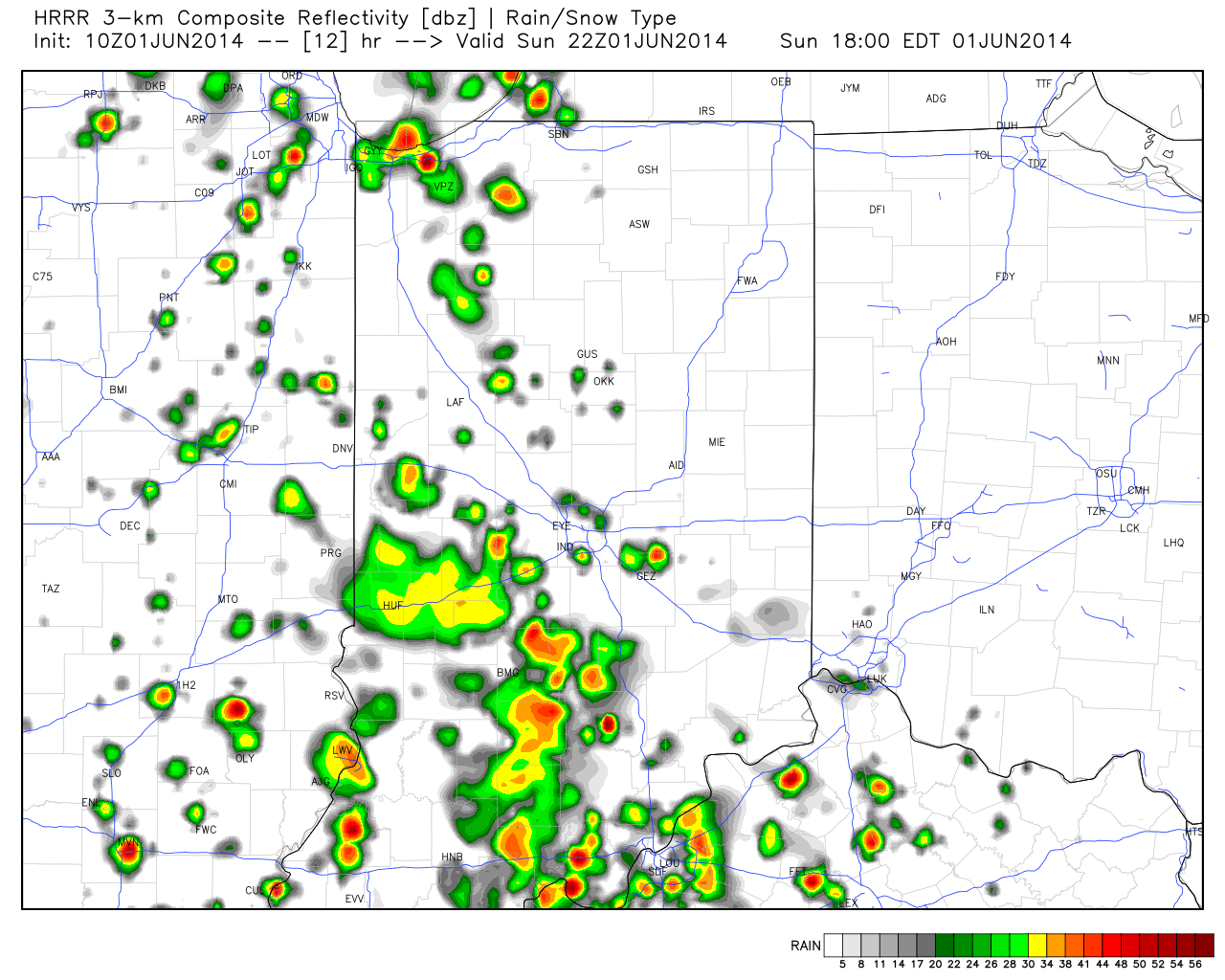
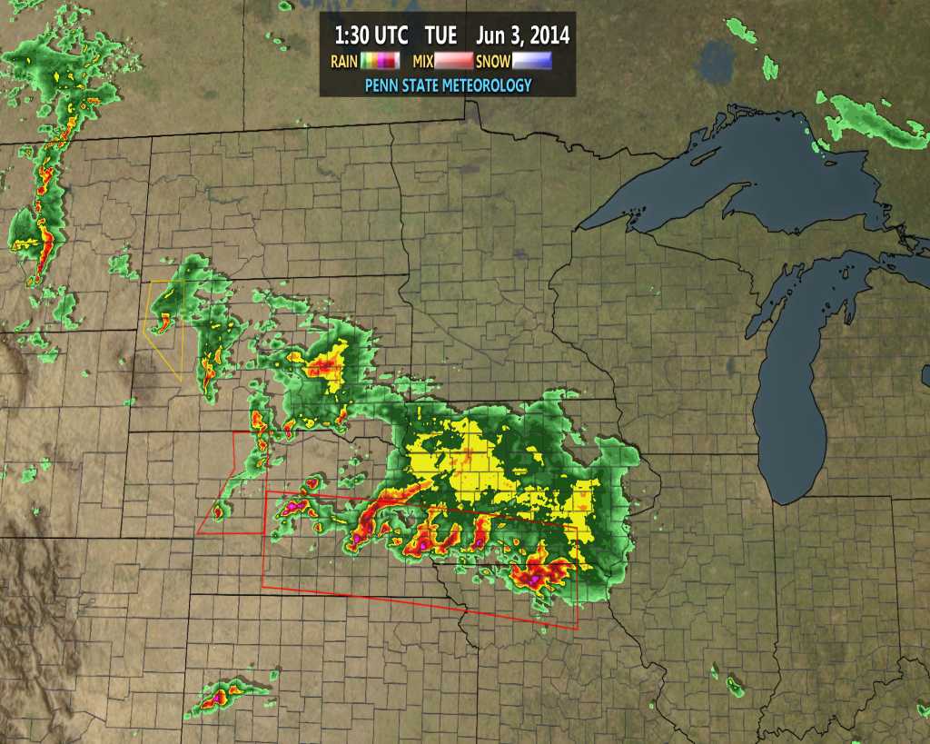
So this post will have to do.  Really our thoughts remain unchanged concerning the way things unfold late tonight and Wednesday.  The severe thunderstorms to our northwest continue to rumble as of the 10 o’clock hour.

ncrad23

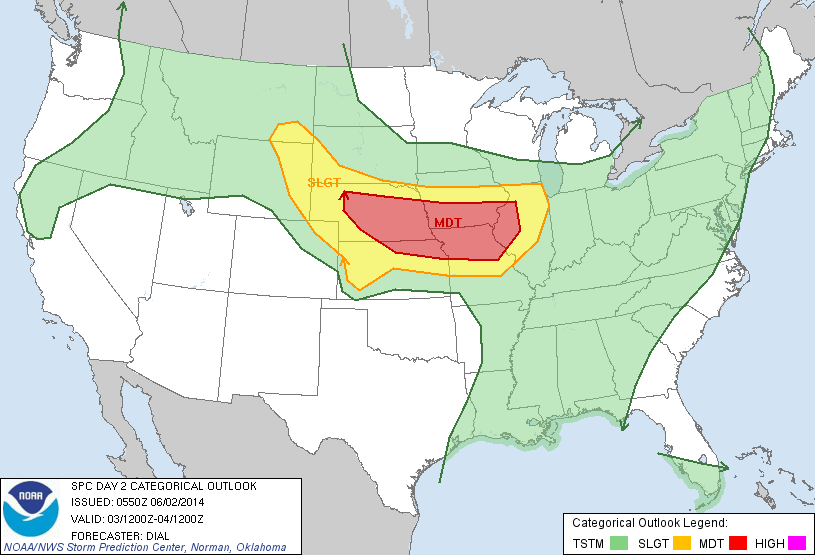
The Storm Prediction Center holds firm to the Slight Risk for the Ohio Valley and northern Tennessee Valley Wednesday.

day2otlk_1730

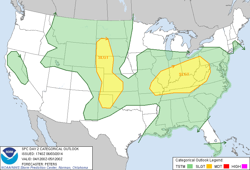
We wouldn’t be surprised to see a portion (most likely the southern half) of the Slight Risk area upgraded to a rare Moderate Risk area with the update from the SPC early Wednesday morning.

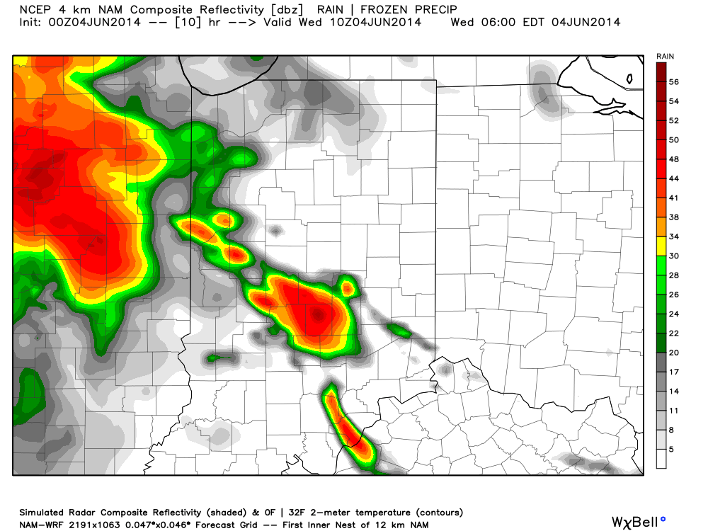
Our thinking hasn’t changed in that we believe the current complex of severe storms arrives into north central Indiana in a weakened state early Wednesday morning.  The rush hour will likely include heavy rain and plenty of thunder, though we think the majority, if not all, of this activity Wednesday morning will remain below severe levels across our immediate region.  Showers and thunderstorms will rumble into the area, especially north of the city during the predawn hours and include plenty of heavy rain.

hires_ref_indy_11

A second round of showers and thunderstorms will fire during the afternoon Wednesday and is likely to turn severe across south central Indiana and points south Wednesday afternoon.  Dangerous conditions are a good bet, including large and destructive hail, damaging straight line winds, and tornadoes.  Certainly if you have plans from Indianapolis to Louisville or Cincy tomorrow afternoon and evening please keep tuned to the latest weather conditions and radar updates.  Further north, the severe potential is much less certain.  We continue to think areas north of the I-70 corridor will struggle to shake the stability provided from the early morning rain and storms.  We caution though that this remains a now-cast scenario and will require a close eye tomorrow afternoon.

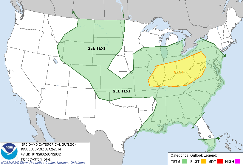
Looking farther ahead, we’ll enjoy a refreshing blast of air Thursday-Saturday with bright sunshine, low humidity, and cooler temperatures.  Warmth and humidity will return Sunday with rainfall potential around 1″ additional precipitation.  This will be followed by yet another big push of cooler, drier air early next week.  More on this in the days to come.

Permanent link to this article: https://indywx.com/tuesday-night-update-southern-indiana-under-gun-for-a-big-severe-weather-day-wednesday/

Watching Wednesday Closely.

Tue.

Wed.

Thr.

Fri.

Sat.

Sun.

Mon.

 Status-weather-clouds-icon

 Status-weather-storm-night-icon

 Status-weather-clouds-icon

 Status-weather-clouds-icon

 Status-weather-showers-day-icon

 Status-weather-showers-day-icon

 Status-weather-clouds-icon

67/ 84

62/ 78

52/ 75

51/ 75

56/ 82

66/ 80

54/ 75 

– – –

Heavy

– – –

– – –

Light

Light

– – –

After a heavy dose of rain across central Indiana Monday, today will be much quieter, AND increasingly sunny!  A boundary will slip south through the afternoon hours and could ignite a shower or thunderstorm, but these will primarily be south and east of the city, itself. We’re going with a more optimistic approach to our forecast today for the greater Indianapolis region and points north.  All eyes will then shift northwest to a blossoming complex of rain and severe thunderstorms this afternoon. We’ll watch this complex track south and east with time tonight and rumble into the region, especially from IND and points north, early Wednesday morning.  Most of these storms will be below severe levels, but the storms are likely to be quite noisy and pack heavy rain, gusty winds, and small hail.  A second round of thunderstorms will develop Wednesday afternoon and likely turn severe for some.  You can read our thoughts from last night here and this continues to sum up our thinking for now.  Widespread additional rainfall Wednesday will fall in the 1″-2″ range.

Get set to open the windows and welcome in a breath of fresh air as we wrap up the work week. Gone will be the warm and sticky air that we’ve dealt with through the early week and in return we’ll enjoy temperatures several degrees cooler along with unseasonably comfortable humidity levels.

Our next rain and storm threat will blow into town Sunday!

Permanent link to this article: https://indywx.com/watching-wednesday-closely/

Monday Morning Video Update; Severe Weather Potential And Heavy Rain…

An active few days lie ahead though it won’t rain and storm the entire time, and many dry hours can be expected over the course of the next few days.  The video covers the details below!

Tuesday is shaping up to be a very active severe weather day to our west.

Tuesday is shaping up to be a very active severe weather day to our west.

Wednesday will feature severe weather chances across the Ohio Valley.

Wednesday will feature severe weather chances across the Ohio Valley.


Permanent link to this article: https://indywx.com/monday-morning-video-update-severe-weather-potential-and-heavy-rain/

Sunday Morning Video Update; Storms Arrive This Evening.

We discuss the regime change from the low humidity, dry, feel to our air mass to one that turns increasingly muggy through the afternoon.  This sets the stage for a rainy, stormy week upcoming.  We think thunderstorms fire across central Indiana as early as 5-6 o’clock this evening.

Future scan radar suggests thunderstorms erupt as early as 5-6pm across central Indiana.

Future scan radar suggests thunderstorms erupt as early as 5-6pm across central Indiana.


Permanent link to this article: https://indywx.com/sunday-morning-video-update-storms-arrive-this-evening/

Saturday Morning Weather Chit-Chat!

A beautiful weekend is underway.  Stepping out on the deck this morning for my morning coffee was much more refreshing when compared to the past few days.  Dew points in the 40s along with temperatures around 60 made for a very nice feel this morning.

This morning’s visible satellite shows clear skies continue.  Definitely plan to get outside today, but with that sun screen!

20140531_1145_EVV_vis

Most of Sunday will be nice, as well, but clouds and humidity levels will increase Sunday afternoon and evening and a couple of showers and thunderstorms will be possible as early as Sunday night.

Future radar shows scattered thunderstorms around the region Sunday night.

hires_ref_indy_43

Warmth and humidity will return to oppressive levels for the better part of next week and this will help add fuel to the fire for heavy rain and potentially strong thunderstorms.  Model data handles the timing differently with next week’s storm system (as is usual at this stage), but agrees on the heavy rain potential.  Widespread 1.5″ to 2″ rainfall appears to be a good bet at this point next week.

Upcoming 10 day rainfall potential, per the Canadian forecast model, shows the wet pattern unfolding, including excessive rains for some locales.

cmc_total_precip_ma_41

The GFS (below) pushes the front south a bit quicker and in return delivers drier air next weekend.  The European forecast model doesn’t agree.

gfs_ptype_slp_east_20

Also of interest, the GFS continues to spin up Gulf of Mexico “mischief” late next week…

gfs_ptype_slp_east_33


Permanent link to this article: https://indywx.com/saturday-morning-weather-chit-chat/