Cloudy, Cool Day; Rain Builds In Later…

We’re off to a cloudy and cool start, but at least things are dry this morning. The frontal boundary that delivered the rain and flooding to central IN Tuesday has…

You must be logged in to view this content. Click Here to become a member of IndyWX.com for full access.  Already a member of IndyWx.com All-Access?  Log-in here.

More Rain And Storms Ahead…

Screen Shot 2015-07-07 at 12.49.30 PMHighlights:

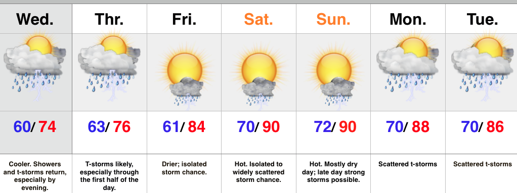
  • Periods of showers and storms through mid week
  • Can’t shake weekend storm chances, but drier, and turning hot
  • Scattered storms return early next week

A frontal boundary will slip south of central IN later this evening and take most of the heavy rain and storms south tonight into a good chunk of Wednesday.  However, the boundary will return north Wednesday evening in response to an area of surface low pressure moving northeast out of the lower and middle MS River Valley.  This will return the focus of showers and heavier thunderstorms for our region Wednesday evening into the first half of Thursday.  Similar to that of today, locally heavy rainfall is a good bet at times.

The area of low pressure will track east Thursday afternoon and take most of the moisture with it.  We’ll forecast drier times to wrap up the work week along with rising temperatures.  While we can’t shake weekend storm chances, Friday through Sunday will be drier, overall, when compared to the next couple days.  With the heat and humidity around, a few strong to severe storms are possible- particularly Sunday afternoon.  We’ll keep an eye on things.

Scattered, “splash and dash,” coverage of storms returns early next week.

Upcoming 7-Day Rainfall Forecast: 2″ – 2.5″

Wednesday Night Rambles…

Just a few thoughts on this Wednesday night… 1.) June officially closed wetter than normal and near average temperature-wise…      The Indianapolis National Weather Service posted this earlier today, further…

You must be logged in to view this content. Click Here to become a member of IndyWX.com for full access.  Already a member of IndyWx.com All-Access?  Log-in here.

Breezy And Much Cooler Today; Beautiful Sunday On Tap…

Flooding is an issue across many central IN communities this morning. Particularly hard hit is the Muncie community.  Zionsville’s Eagle Creek is also above flood stage this morning.    Thankfully, breezy…

You must be logged in to view this content. Click Here to become a member of IndyWX.com for full access.  Already a member of IndyWx.com All-Access?  Log-in here.

Heavy Rain And Storms To Close The Work Week…

An area of low pressure will track across the Ohio Valley Friday and help rain overspread the region from west to east as the day progresses. Embedded thunderstorms can also…

You must be logged in to view this content. Click Here to become a member of IndyWX.com for full access.  Already a member of IndyWx.com All-Access?  Log-in here.