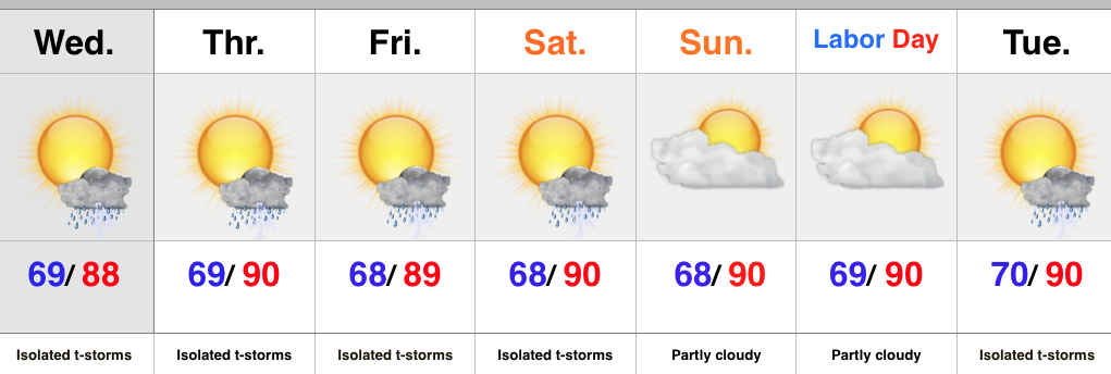
Category: Heavy Rain

Still Some Question On Northward Extent Of Heavy Rain…

The morning is off to a beautiful start as drier air oozed into central IN overnight.  Many reporting sites are returning numbers in the middle 50s this morning!  Anyone else craving fall?

While a beautiful day is in store locally, we note clouds associated with a storm complex off to our northwest this morning.  Some of these clouds could blow into central IN at some point this afternoon or evening.

As we fast forward to mid week the cold front that’s currently to our south will lift back north as a warm front.  This will be in response to surface low pressure tracking in west to east fashion through the central Plains and into the Ohio Valley.  That said, there’s precise details still not etched in stone that can, and will, have a large impact on our weather (locally) Wednesday night though Thursday.  Note some of the differences with just a few of our forecast models in regards to heavy rainfall placement:

High-resolution NAM

1GFS (interestingly the 6z GFS shunted the rain farther south):

5Canadian:

3* The European most closely resembles the 0z GFS run.

We still have time to sort through the details in regards to the precise placement of heaviest rain, but for now we’re keeping widespread rain and embedded thunder in the forecast Wednesday night through Thursday.

Note precipitable water values exceeding 2″ in spots Thursday.  This will certainly support locally heavy rain and a flash flood threat for portions of the state during the aforementioned time period.  Much more later this evening!

2

Permanent link to this article: https://indywx.com/still-some-question-on-northward-extent-of-heavy-rain/

Early Morning Storms…

Screen Shot 2015-08-02 at 10.25.16 PMHighlights:

  • Monday morning storms
  • Wet mid week stretch
  • Keeping a watchful eye to the northwest

As we type this, storms are expanding and intensifying in coverage to our north, across the Great Lakes region.  We expect these storms to continue to build west as they sink south and southeast with time.  As such, don’t be surprised by a predawn wake-up call,  courtesy of Mother Nature Monday morning.  A few storms could be strong to severe with the primary concern being damaging winds.

After a nice Tuesday, low pressure will track east and provide widespread rain and thunderstorms Wednesday into Thursday.  Locally heavy rainfall is a good bet.

Once to late week and the weekend, confidence begins to lower.  We’ll remain in a challenging northwest flow and models can struggle in handling specific features.  That said, we’re keeping our fingers crossed for pleasant weather to wrap up the work week and head into the weekend, along with well below normal temperatures.  Rain and storm chances return Sunday.

Upcoming 7 Day Rainfall Forecast: 2″ – 3″ with locally heavier totals

Permanent link to this article: https://indywx.com/early-morning-storms/

Awesome Open To The Weekend; Wet Pattern Quickly Returns…

Screen Shot 2015-07-31 at 11.17.18 PMHighlights:

  • Beautiful Saturday ahead
  • Wet and stormy pattern returns
  • Cooler than normal air arrives

We couldn’t ask for a better start to the weekend.  Today will feature lots of sunshine, pleasant humidity and temperatures, and absolutely perfect conditions to spend time outdoors!  Enjoy because active times return for the second half of the weekend that will carry us into next week.

As promised, we’re heading back into a very busy weather pattern.  The hot dome of air (ridge of high pressure) will shift southwest and allow multiple disturbances to ride the outer periphery of the ridge in a northwest to southeast fashion.  Each disturbance will be capable of producing periods of showers and thunderstorms- some of which may produce locally heavy rainfall.

As we progress into the latter portion of the work week questions abound.  How far does drier air penetrate south?  What’s the precise location of the ridge?  Both will have to be answered in due time.  For now, we’re sticking with an unsettled regime with progressively cooler air.  If some of the drier solutions verify then we’ll remove rain and storms altogether once past Thursday and introduce even cooler air.  Stay tuned.

Upcoming 7-Day Rainfall Forecast: 1.5″ – 2″ (locally heavier totals)

Permanent link to this article: https://indywx.com/awesome-open-to-the-weekend-wet-pattern-quickly-returns/

Hot And Humid With Storms, But Relief Is Coming…

Screen Shot 2015-07-28 at 11.34.23 PMHighlights:

  • Thundery Wednesday
  • Much more refreshing feel to close the week
  • Storm chances return early next week

A cold front will move through the region Wednesday afternoon and evening.  The front will slice into a very warm and humid air mass so strong to severe thunderstorms will be possible, especially late morning into the afternoon/ evening.  We’re not forecasting widespread severe, but with all of the moisture in the atmosphere, locally heavy rain and additional flash flooding can’t be ruled out.

At any rate, a much more pleasant feel can be expected to wrap up the work week. We note dew points plunge from the upper 70s Wednesday morning into the upper 50s Thursday morning.  Talk about nice!

While we have to maintain a mention of a shower over the weekend, the majority will be rain-free.  The pesky NW flow aloft may push a weak disturbance into central IN so we have to mention the threat of an isolated shower Saturday into Sunday.

Looking ahead, next week is potentially an active one, including a heavy rain threat followed by a big push of early August cool air.

Upcoming 7-Day Rainfall Forecast: 1.5″ – 2″ (locally higher totals under storms)

Permanent link to this article: https://indywx.com/hot-and-humid-with-storms-but-relief-is-coming/

August Outlook

Before we dive into what we expect for the month of August, here’s a look at where we stand so far for July (with 4 days left as of this post).

This was our July forecast upper air pattern, issued 6.29:

July2015UAHere’s a look at temperature anomalies through 7.27:

ncep_cfsr_noram_t2m_anomWhile overnight lows have been running warm with all of the clouds and moisture, daytime highs have been significantly below average:

tmax30dydevWith four days left in the month, it’s already been the wettest month on record at IND.  The Corn Belt, as a whole, has been quite wet month-to-date.

nws_precip_conus2_mtd nws_precip_indy_mtd precip30dydevAs we progress into August (where does time go) we think we continue in an active pattern, locally, biased cooler than normal and wetter than normal.

AugustUA2015While modeling disagrees with the specifics in regards to the timing, most mid to long range modeling does agree on the overall idea of the hot dome (ridge) backing west and setting up shop over the southwest portion of the country early August which will put our region in (you guessed it) the favorable northwest flow for active weather.  Similar to July, disturbances will ride the periphery of the hot dome to our southwest and offer up plenty of chances for showers and thunderstorms.  That’s not to say we’re looking at setting another record for greatest amount of rain within a month, but it is saying precipitation should be above average yet again.

From time to time the ridge will attempt to expand northeast, but we don’t think it’s potentially until the last portion of the month before the ridge has much chance to encompass our region for any staying power more than a few days.  We suggest getting used to this 500mb look:

EarlyAugThe latest NAEFS and CFSv2 highlights the cooler than normal period we should undergo early August (especially after the 5th).

wk1.wk2_20150726.NAsfcT2015072712_054@007_E1_north@america_I_NAEFS@TEMPERATURE_anomaly@probability@combined@week2_186The latest European Weeklies suggest there may be a window for a “calmer” regime after the 25th.  That said, it’s a rather volatile pattern.

Yet another tool we’ve been keeping a close eye on the past few months has been the SOI (Southern Oscillation Index) as it’s been a big help in tipping us off for prolonged wet weather.  Note the consistent negative SOI:

Screen Shot 2015-07-27 at 11.22.11 PM


World

Not to sound like a broken record, but we continue to think the relentless wet weather pattern “keeps on keepin’ on” as we progress through August.  It’s very interesting to note the dynamics at play between the strengthening El Nino and warm northeast PAC waters… More on that, and the implications we feel for fall and winter, in the weeks and months ahead. 🙂

July2015SST

Permanent link to this article: https://indywx.com/august-outlook-2/