Monday Evening Update…

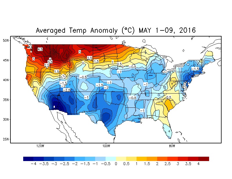
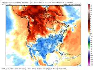
Through the first half of May, temperatures are running more than 2 degrees below average at IND.  We’re in the middle of a rather large area of below normal temperatures from the SW into the NE region.

ncep_cfsr_noram_t2m_anom
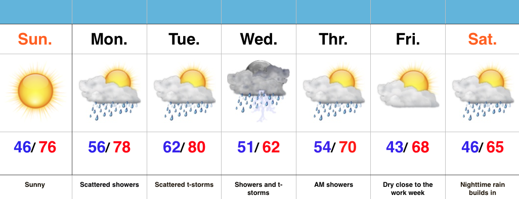
We’ll remain below average through the upcoming week, but temperatures will begin to moderate over the weekend into next week.

KEYE_2016051612_nxa_384
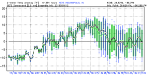
In general, we agree with the temperature anomalies above, courtesy of the GEFS.  As noted, the cool start to the period will moderate and turn warmer next week.  Unfortunately, that warmer trend won’t last and it’s likely we trend cooler around the Memorial Day weekend.

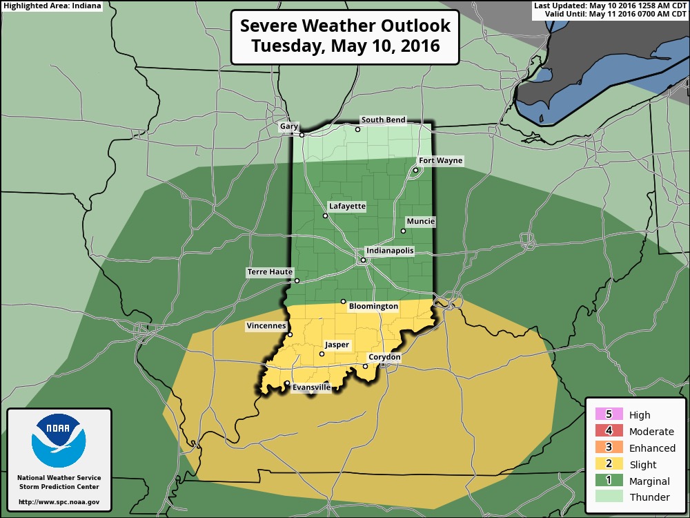
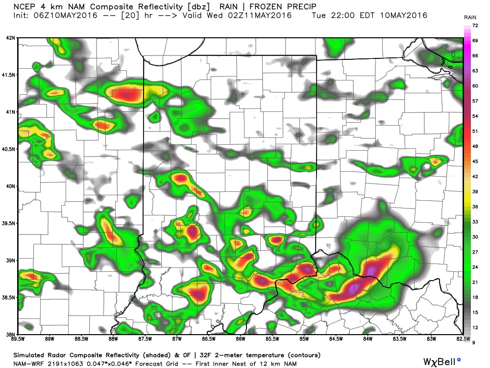
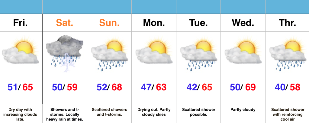
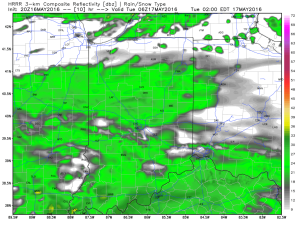
In the shorter range, light rain will spread into central IN late tonight into Tuesday.  Rainfall amounts won’t be significant, and should be generally around 0.25″, or less.

1Drier air is still expected for mid week, as high pressure builds into the region.  Needed sunshine and pleasant conditions can be expected.

2
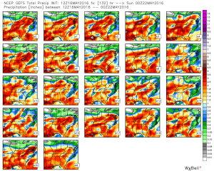
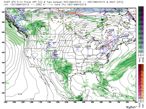
As we look forward to the weekend, modeling is still at odds with one another.  The European remains consistent on the idea of heavy rain while the GFS remains consistent on a drier solution (rain, but much lighter amounts).  That said, we note the consensus of the GFS ensemble members is more aggressive and reflects the idea of the European.  We’ll remain firm on the idea of potentially heavy rain building in Friday into Saturday.

gefs_qpf_ens_ky_23

Tuesday Morning Rambles…

1.) The month of May has gotten off to a chilly start and given the period of unseasonably chilly air that looms later this week, it’s safe to say these cool anomalies will grow even cooler. 

The coolest day looks to be Saturday with highs only in the mid 50s.


2.) In the shorter term, we’re keeping an eye on strong-severe thunderstorm potential this afternoon and evening across southern and central parts of the state. Large hail and damaging straight line winds are of greatest concern, but a quick spin-up tornado can’t be ruled out.


Not everyone will see heavy rain amounts today, but a few neighborhoods may deal with localized flooding issues as slow moving heavy storms potentially train over communities. Where this happens, 2″+ rain totals are a good bet by midnight.


3.) Forecast models remain in a state of disagreement concerning late this weekend into early next week. The GFS is particularly bullish on the idea of wet (heavy rain threat), chilly times whereas the European is much drier (and warmer). We’ll keep an eye on things and hope for consistency this afternoon. Speaking of this afternoon, we’ll have our updated 7-day posted later today! Make it a great Tuesday. 

Dry Time Is Brief; Wet Saturday Ahead…

Screen Shot 2016-04-29 at 7.52.07 AMHighlights:

  • Friday sunshine before clouds increase late
  • Unsettled weekend
  • Reinforcing cool air next week accompanied by showers

Enjoy The Sun While We Have It…A dry day is on tap and while it’s gotten off to a sunny start, clouds will be on the increase late today.  Those clouds will deliver rain and scattered thunderstorms Saturday.  Some of the rain may be locally heavy.  We’re looking at widespread 1″-1.5″ totals, but there will be locally heavier amounts.  While scattered showers and thunderstorms will remain Sunday, the wetter of the two weekend days is slated for Saturday.

The work week will start dry with increasing sunshine, but cooler.  Reinforcing cool air will blow in Tuesday and again Thursday.  Each cool air reinforcement could be accompanied by a scattered light shower.  That said, next week looks significantly drier with compared to this week.

Another Round Of Storms This Afternoon…

Heaviest concentration of storms Tuesday was along the I-70 corridor and points south.  We think today coverage of rain and thunderstorms will be more widespread across the state…

We’re off to a cool and quiet start this morning, but think things will turn rather busy yet again as early as the early-mid afternoon hours.  Unsettled conditions will continue through the night.

Latest scans of the HRRR future-cast radar product suggests we need to monitor for high wind potential during the early to mid afternoon hours.  We’ll keep a close eye on this.

1

2The high resolution NAM future-cast radar is slower, but also shows strong to possibly severe storms into central IN late tonight.

3The current SPC outlook highlights far southwestern IN for the chance of severe weather today. Don’t be surprised if this is expanded northeast with later updates today.

4Rainfall potential today-tonight should feature many neighborhoods accumulating an additional inch, with some locally heavier totals.

Beauty Of A Sunday…

Screen Shot 2016-04-24 at 11.14.16 AMHighlights:

  • Sunny close to the weekend
  • Warm and increasingly humid early week with showers
  • Widespread rain and storms Wednesday
  • Significant rain maker to open May

Good Supply Of Vitamin D…High pressure will remain in control of our weather today and supply mostly sunny skies and warm temperatures.  Get outside and enjoy!

Moisture will begin to increase as we progress through the early portions of the work week with showers and scattered thunderstorms developing Monday into Tuesday.  We’ll still enjoy lots of dry time in between the scattered showers.

More widespread showers and thunderstorms will push into the state Wednesday.  Early numbers suggest amounts of 0.75″-1″.  Lingering showers remain Thursday morning, but we should get a nice push of dry air in here Thursday afternoon into Friday.

Attention will then shift to a significant system that promises to provide heavy rain and embedded thunderstorms as early as Saturday night.  We still have time to watch this, but from this distance it appears as if this will be a “juicy” storm system.  We’re also eyeing a much cooler open to May…