VIDEO: Quick Wednesday Evening Video Update…
You must be logged in to view this content. Click Here to become a member of IndyWX.com for full access. Already a member of IndyWx.com All-Access? Log-in here.
You must be logged in to view this content. Click Here to become a member of IndyWX.com for full access. Already a member of IndyWx.com All-Access? Log-in here.
 Highlights:
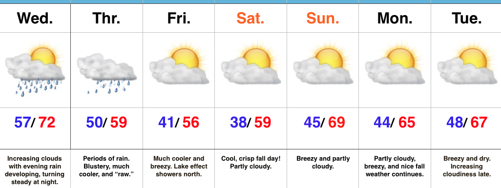
Find The Rain Gear…Most of Wednesday will feature dry conditions with lots of sunshine to start, but clouds will be on the increase and rain will follow. We expect rain coverage to increase from south to north as evening gives way to nighttime. This is all in association with a surface low developing along a stationary boundary to our south. This area of low pressure will track along the Ohio River (Thursday) to the interior northeast (Friday). (Indiana snow enthusiasts know that’s a perfect track for the snowy “goods” if only it was a month, or so, later). We will continue to dream… 🙂
Back to regularly scheduled programming…
Rain will grow in coverage and intensity Wednesday night into early Thursday morning and periods of rain will be with us through the day Thursday. Heaviest rains should fall through the southern half of the state (where localized 2″+ totals are possible). The other weather element we’ll have to deal with Thursday is an increasingly chilly and raw northeast wind shifting to the north late. Temperatures will remain steady and slowly fall by evening.
As the area of low pressure pulls off to the northeast, it’ll help drive the coolest air of the season southward. Patchy frost is possible for outlying areas Saturday morning. Fall foliage should be looking “really nice” this weekend across central IN.
Dry, but breezy, conditions will be with us early next week, but we’re eyeing our next storm system by the middle to latter portions of the week.
Upcoming 7-Day Precipitation Forecast:
You must be logged in to view this content. Click Here to become a member of IndyWX.com for full access. Already a member of IndyWx.com All-Access? Log-in here.
 Highlights:
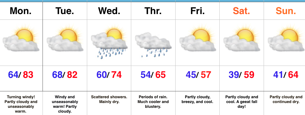
A Little Something For Everyone…The big story over the next 24-48 hours will be unseasonably warm temperatures, but equally as impressive, strong and gusty winds (30-40MPH). Enjoy the extended period of shorts and short sleeves, but please note a “big hair warning” is in effect through Tuesday night. 🙂
A cold front will slip through the state Wednesday (from north to south) and could spark a scattered shower as it drifts south. Eventually the front will stall along the KY border. This is in response to an area of low pressure developing to our southwest. The surface low will lift northeast and help spread widespread soaking rain across the state Thursday. Additionally, we’ll note a much cooler air mass and winds that will shift around to the north in the PM, helping drive a much cooler close to the week. Moderate to locally heavy rainfall can be expected Thursday.
As we get set to put a wrap on the week, we’ll get back to weather we’d expect for this time of year: dry, cool, and crisp! In fact, patchy frost is possible Saturday morning across outlying areas away from the city.
Upcoming 7-Day Precipitation Forecast:
 Highlights:
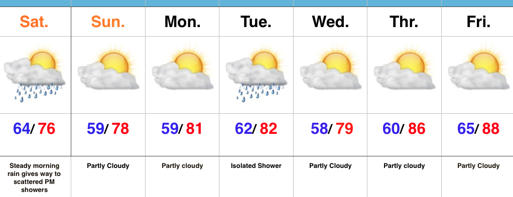
Drying Out Sunday…It was a wet and stormy night across central IN, including locally hefty rainfall totals (some neighborhoods picked up more than 2″). We’ve been dealing with widespread soaking rain across central IN through the morning, but as we progress into the afternoon, most concentrated rain will remain east of the city and on into Ohio. Scattered showers will remain possible until the cold front presses through the region tonight.
High pressure will build overhead Sunday and supply increasing sunshine and a pleasant second half of the weekend. Lower humidity will promote overnight lows into the upper 50s to open the week.
A secondary (weak) front may yield an isolated to widely scattered shower Tuesday, but the bigger story will be late season heat building to close the week. Highs will approach the 90 degree mark by Friday as a big ole ridge expands across the region.
Longer term, a significant cold front looms just beyond the current forecast period that will offer up thunderstorms and a big blast of fall-like air to close the month…
Upcoming 7-Day Precipitation Forecast: