Updated 06.08.22 @ 7:27a
You must be logged in to view this content. Click Here to become a member of IndyWX.com for full access. Already a member of IndyWx.com All-Access? Log-in here.

Jun 08
Updated 06.08.22 @ 7:27a
You must be logged in to view this content. Click Here to become a member of IndyWX.com for full access. Already a member of IndyWx.com All-Access? Log-in here.
Permanent link to this article: https://indywx.com/video-detailing-todays-severe-threat-few-days-of-intense-heat-humidity-arrives-next-week/
Apr 30
Updated 04.30.22 @ 5:30a
Our Saturday will open on a calm, quiet note, but changes are brewing…
The Storm Prediction Center (SPC) continues to include the western half of the state in a Slight Risk of severe weather (including Indianapolis).

We focus in on the mid to late afternoon hours for storm initialization- specifically around 3p to 4p into the city, itself. This will likely only be the first of multiple rounds of storms into the nighttime hours. In fact, strongest storms likely won’t impact the region until after sunset, continuing up until around midnight.
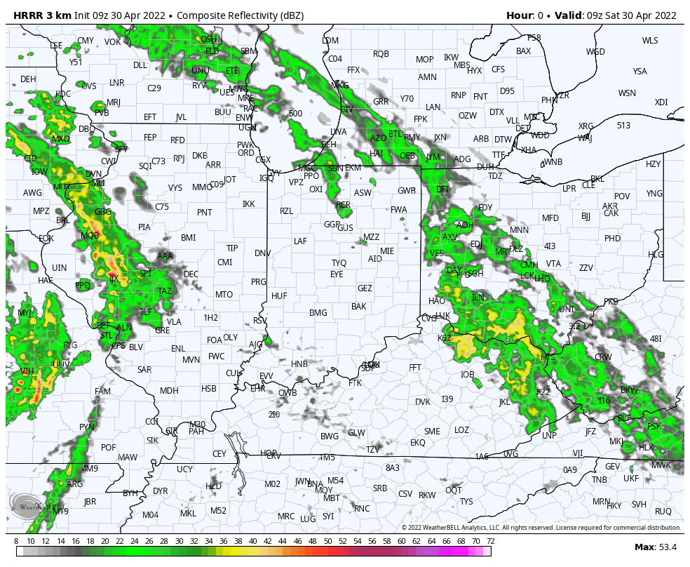
Damaging wind is the biggest concern with stronger storms, but a few cells could contain hail and we can’t completely rule out the chance of a quick spin up.
Locally heavy rain is also expected, especially where storms train over the same communities. Most communities in and around Indianapolis can expect to pick up at least an inch of rain, with some closing in on 2”.

The good news is that all of this will clear out of here for the 2nd half of the weekend leading to a much more pleasant time of things Sunday.
More on this and looking ahead to the 1st half of May a bit later today!
Permanent link to this article: https://indywx.com/saturday-opens-quiet-ends-stormy/
Mar 23
Updated 03.23.22 @ 7:35a
You must be logged in to view this content. Click Here to become a member of IndyWX.com for full access. Already a member of IndyWx.com All-Access? Log-in here.
Permanent link to this article: https://indywx.com/video-severe-weather-develops-this-afternoon-unseasonably-cold-stretch-on-deck/
Mar 22
Updated 03.22.22 @ 6:52a
A shield of rain is lifting into central Indiana during the predawn hours and once it arrives, we can expect wet times to persist through the better part of our Tuesday.

This is all part of a surface low that will lift northeast out of the central Plains region (today) into the lower Great Lakes region (Thursday). In association with this low pressure system, a warm front will lift northeast across the region Wednesday. Eventually, a cold front will move from west to east and sweep the state Wednesday night and early Thursday.
As this all transpires, a steady “all day” soaker can be expected across the region today.

Heaviest rain will be confined to western and northwestern parts of the state where amounts of 2″+ can be expected by 7a Wednesday. For immediate central and eastern Indiana, amounts of 0.50″ to 1.25″ can be expected by Wednesday morning.

Precipitation will turn more “showery” in nature by Wednesday morning, but by this timeframe, all eyes will be turning to the potential of thunder Wednesday afternoon as just enough instability and cold air aloft combine. From the city, itself, and points north and east, the threat of a few stronger cells are present Wednesday afternoon (after lunchtime). With the ingredients in place, a few of these storms could produce hail as they race off to the northeast.


We’ll turn MUCH cooler Thursday and Friday with a few “nuisance” variety showers around, but compared to what we see today and Wednesday, these won’t be a big deal (just annoying ;-)).
The colder times continue into the weekend and early portions of the next week and with a fast northwesterly flow aloft, a couple of disturbances will likely deliver the potential of mixed rain/ snow showers Saturday and again Monday.


We still expect a hard freeze (25° to 30°) early next week for a good chunk of the region.

Permanent link to this article: https://indywx.com/persistent-rain-gives-way-to-some-hailers-wednesday-pm-colder-shift-with-wintry-precipitation-this-weekend-into-early-next-week/
Mar 06
Updated 03.06.22 @ 9:20a
You must be logged in to view this content. Click Here to become a member of IndyWX.com for full access. Already a member of IndyWx.com All-Access? Log-in here.
Permanent link to this article: https://indywx.com/video-another-round-of-severe-weather-downstate-late-tonight-convective-snow-squalls-monday-pm-and-looking-ahead-to-the-potential-of-a-late-week-winter-event/