Category: Hail

Fantastic Weather Heading Into The Holiday Weekend!

Thr.

Fri.

Sat.

Sun.

Mon.

Tue.

Wed.

 Status-weather-clear-icon

 Status-weather-clear-icon

 Status-weather-clear-icon

 Status-weather-clouds-icon

 Status-weather-showers-day-icon

 Status-weather-showers-day-icon

 Status-weather-showers-day-icon

58/ 74

52/ 70

48/ 74

53/ 79

60/ 84

65/ 86

68/ 83 

– – –

– – –

– – –

– – –

Light

Light

Light

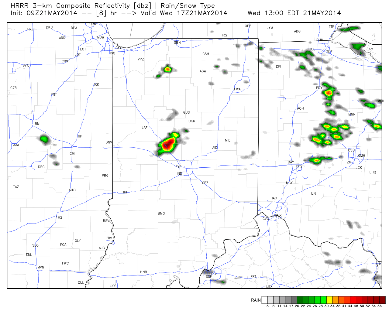
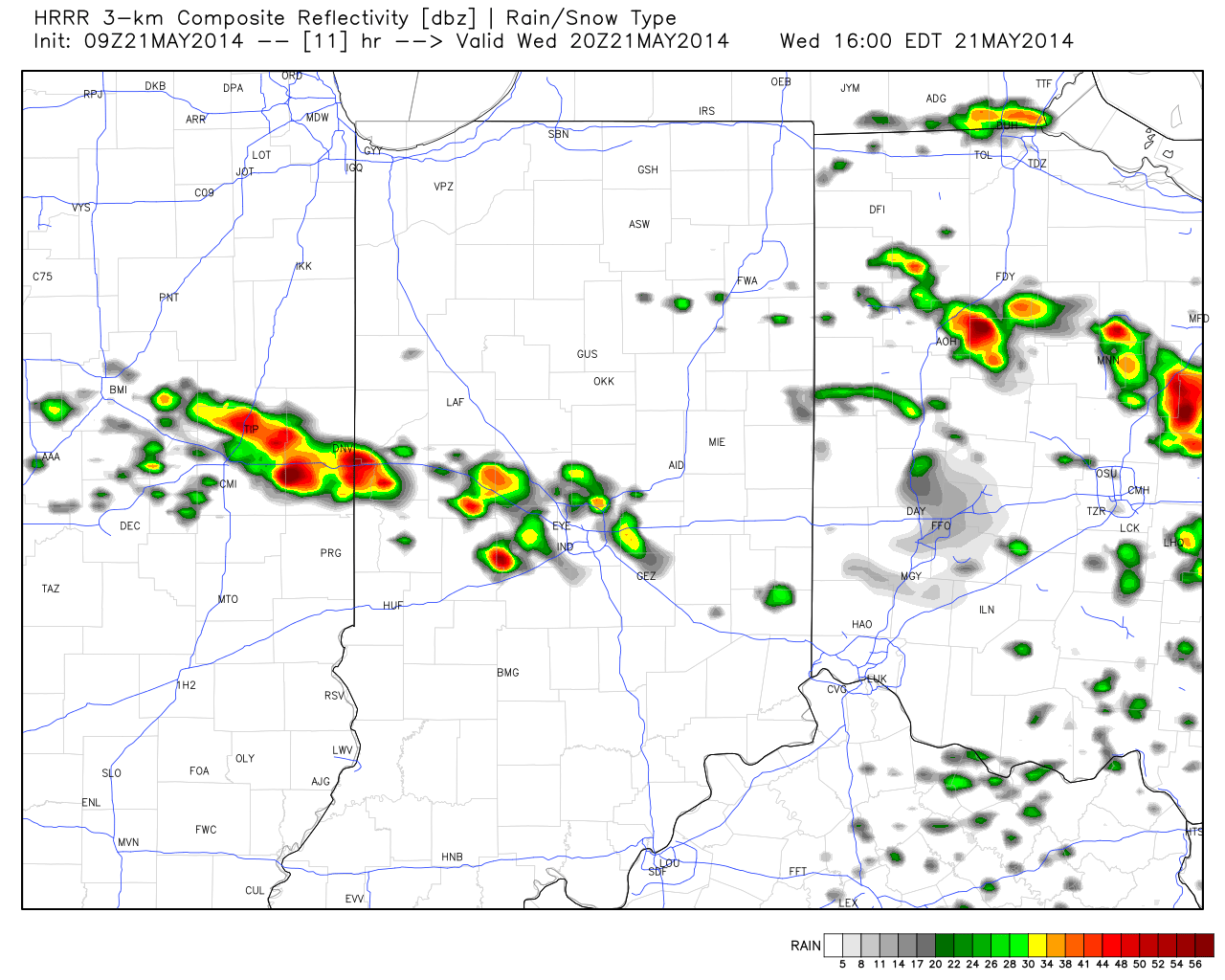
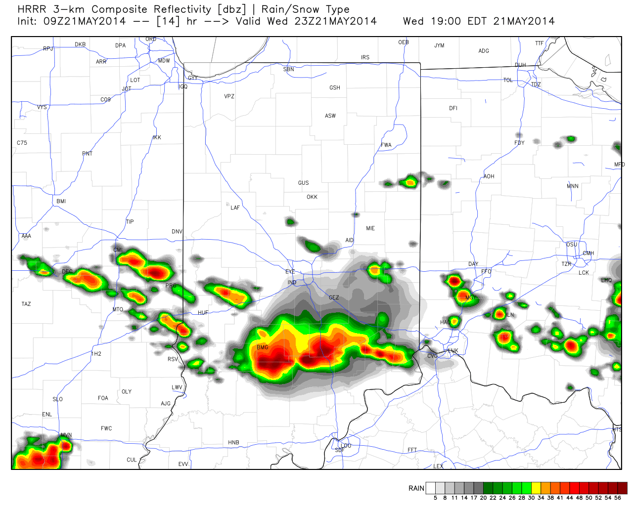
After a stormy Wednesday that featured flooding, hail, and wind damage, today will be a refreshing change!  The cooler, drier, and sunny start to the day is a sign of things to come for the long holiday and race weekend!  A weak disturbance could add a few clouds tonight and a shower downstate, but most will stay dry.  High pressure will then supply wall-to-wall sunshine and cooler air as we wrap up the work week and head into the long weekend.  A hotter, more humid air mass will build in for Memorial Day, itself, and result in a muggy feel along with scattered showers and thunderstorms early next week.

Permanent link to this article: https://indywx.com/fantastic-weather-heading-into-the-holiday-weekend/

Damaging Hail Threat Looms For Central, Southern Indiana This Afternoon.

The morning is dawning pleasant and quiet, but things appear to get quite noisy and active around these parts later this afternoon.  A cold front will slice into the warm and humid air mass in place across the region and thunderstorms will erupt in rather explosive fashion as early as the early to mid afternoon hours.  Damaging straight line winds and large hail are of greatest concern.

The Storm Prediction Center (SPC) highlights the region for an enhanced risk of large and destructive hail this afternoon.

day1otlk_1200


day1probotlk_1200_hail

Here’s a look at what the simulated forecast radar may resemble this afternoon, as always, courtesy of Weatherbell Analytics:

Forecast Radar 1pm

Forecast Radar 1pm


Forecast Radar 4pm

Forecast Radar 4pm


Forecast radar 5pm

Forecast radar 5pm 

Forecast radar 7pm

Forecast radar 7pm

Now it’s important to note not everyone will see destructive severe weather (as is usually the case with any severe weather outbreak), but signals point towards the possibility of a rather significant and large scale severe hail event across central and southern portions of the state this afternoon and evening.  It’ll be very important to stay tuned to your favorite media and certainly heed all warnings that come out this afternoon.

We’ll clear things out nicely later tonight and Thursday and set the stage for an absolute beauty of a holiday and race weekend.  We forecast bright, sunny skies each day along with cool temperatures that slowly warm to the upper 70s for race day, itself.  We’ll introduce the next threat of storms for Memorial Day amidst bubbling true summer heat and humidity for next week.

Permanent link to this article: https://indywx.com/damaging-hail-threat-looms-for-central-southern-indiana-this-afternoon/

Severe Weather Video Brief Tonight-Wednesday

The region remains under fire for severe weather potential, primarily for damaging straight line wind and hail per latest thinking.  The video uncovers when you can expect this and looks ahead to the all-important Memorial Day and Indianapolis 500 weekend!

The region is under fire for severe potential Wednesday.

The region is under fire for severe potential Wednesday.

Permanent link to this article: https://indywx.com/severe-weather-video-brief-tonight-wednesday/

Eyeing Storms Wednesday; Beauty Of A Weekend On Deck!

Tue. Wed. Thr. Fri. Sat. Sun. Mon.               57/ 80 64/ 80 58/ 74 51/ 72 49/ 74 52/ 78 61/ 84  Light Light…

You must be logged in to view this content. Click Here to become a member of IndyWX.com for full access.  Already a member of IndyWx.com All-Access?  Log-in here.

Permanent link to this article: https://indywx.com/eyeing-storms-wednesday-beauty-of-a-weekend-on-deck/

Slow Improvements…

Sat.

Sun.

Mon.

Tue.

Wed.

Thr.

Fri.

 Status-weather-showers-day-icon

 Status-weather-clouds-icon

 Status-weather-clouds-icon

 Status-weather-showers-day-icon

 Status-weather-showers-day-icon

 Status-weather-showers-day-icon

 Status-weather-showers-day-icon

40/ 57

38/ 64

43/ 68

55/ 78

65/ 81

62/ 76

53/ 73 

Light

– – –

– – –

Light

Light

Light

Light

“Improvement” will be the weather word of the weekend, but it’s going to take a couple of slow baby steps before we see full-blown improvement (we think that comes Sunday)!  Today will feature more sunshine than Friday, but with plenty of cold air aloft, it won’t take long for that May sun to do it’s dirty work and help showers bubble up this afternoon.  While some small hail will be possible with the showers, hail reports won’t be nearly as widespread as what we saw Friday.  Temperatures will remain well below normal.  We finally think we can shake shower chances Sunday and introduce a partly cloudy sky.  Early next week looks dry, as well, until a warm front lifts north Tuesday.  This will introduce a much warmer, muggy brand of air to central Indiana and allow for the chance of scattered showers and thunderstorms for mid and late week.  A weak frontal boundary will slip south Thursday into Friday which will knock temperatures back a few degrees to wrap up the work week.  Rainfall amounts through the period will remain rather light, but some local downpours are possible in the muggy air mass mid week.

Forecast radar valid at 2p today shows scattered showers developing.

Forecast radar valid at 2p today shows scattered showers developing.

Permanent link to this article: https://indywx.com/slow-improvements/