It doesn’t get any better around these parts this time of year than what we experienced Monday. Unfortunately, today marks the return of unsettled weather that will continue through midweek. The reward after going through a few days of rain/ storms? An incredible weekend, complete with a return of sunshine!
While unseasonably warm air will build in here early next week, don’t put away the cold weather gear just yet. We’re likely even looking at additional frost threats as we get towards late next weekend and/ or early Week 2. More details below in this week’s #AGwx and #Severe Weather Outlook.
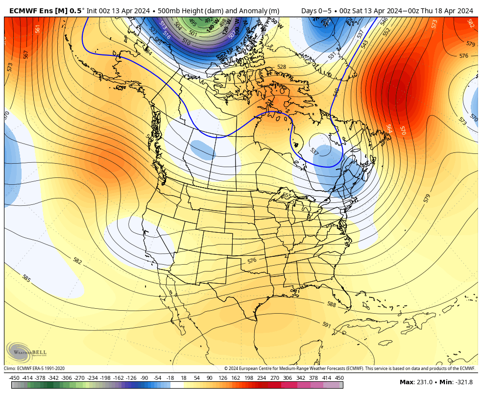
“Transitional” is the word to describe the upcoming couple weeks worth of weather around these parts. The warmth to open the period will cool significantly next weekend and early Week 2, only to give way to renewed warming late April.
Note the roller coaster in the temperature anomalies over the next couple of weeks.
The active pattern in the week ahead will dry significantly late in the forecast period as the cooler airmass takes hold.
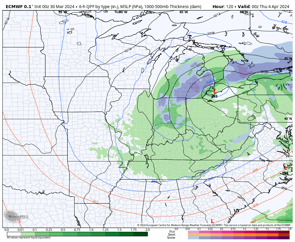
In the more immediate term, we’re tracking 2 storm systems in the week ahead: Tuesday – Wednesday and again Thursday night into Friday.
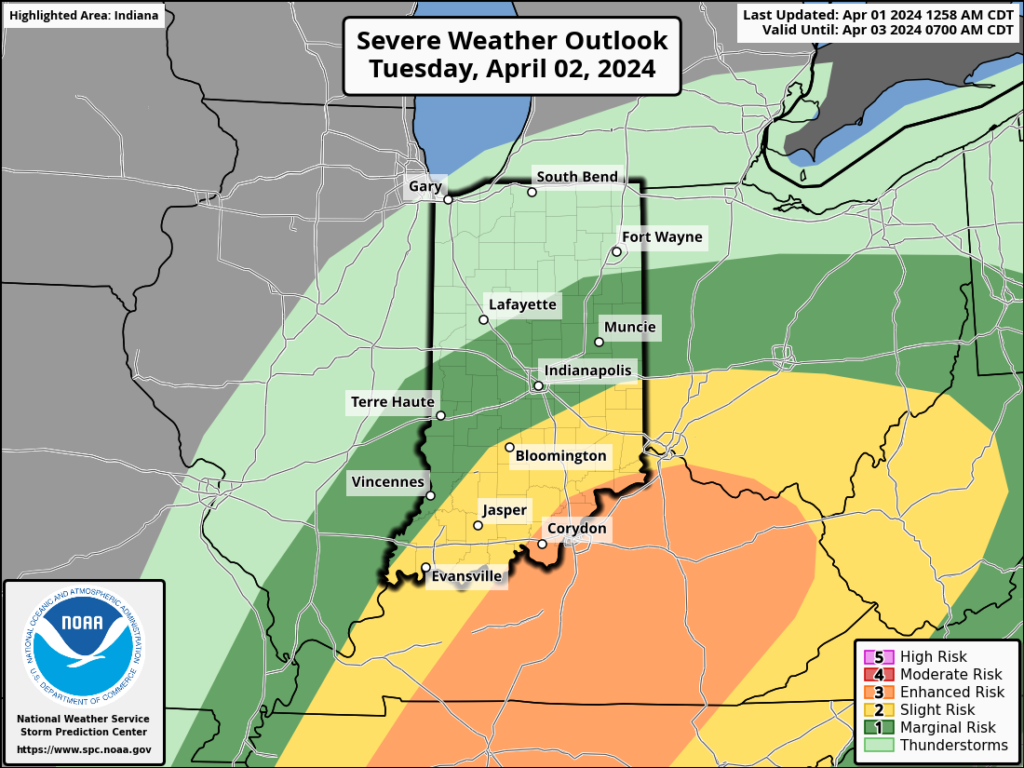
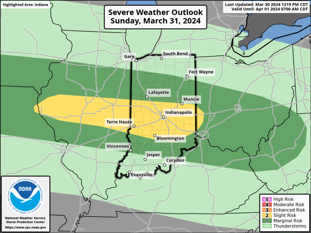
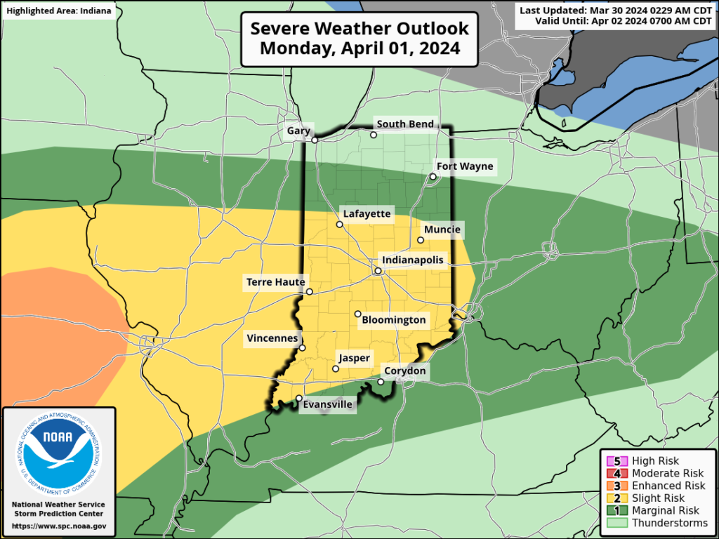
The Storm Prediction Center includes western Indiana in a risk of severe weather Tuesday. We’ll monitor for the potential of a further east extension of this risk area.
We think (2) rounds of storms are on deck Tuesday. The first round likely is associated with a warm front lifting north through the state Tuesday morning (hail threat) followed by a second round of activity Tuesday night into Wednesday morning (main concern being damaging straight line winds with this round). As of now, storm total rainfall amounts of 0.50″ to 1″ seem likely during this timeframe.
Another round of showers and embedded thunder will precede a blast of chilly air next weekend. We bracket Thursday night into Friday morning for this particular round of rain. An additional half inch, or so, of rain seems reasonable from this distance.
By the time we get to next weekend and early Week 2, drier and much cooler, more stable air should take up residence.
We note the warm open, chilly finish in the 10-day meteogram. Also note the frost threat at the end of this period.
I. Things will turn quite active later tonight and into our Tuesday. Multiple rounds of heavy rain and strong thunderstorms will track across central Indiana. As heavy rain trains over the same area, localized flooding will develop Tuesday morning into the afternoon hours.
A threat of severe weather is also present, including large hail and even a couple tornadoes. Given the current parameters, it wouldn’t be a surprise if the fine folks at the Storm Prediction Center expand the current risk zones a bit further north for both the Day 1 and Day 2 outlooks. We’re still tracking a potential line of severe weather Tuesday PM after the multiple rounds in the morning. We’ll want to remain weather-aware tonight and Tuesday across central Indiana.
II. Much colder air will pour in here Wednesday and as the closed upper level low swings through the Great Lakes and Ohio Valley, a renewed area of precipitation will expand across the area Wednesday night into Thursday. Rain will mix with and even change to wet snow in spots across central Indiana during this time. Heavier wet snow bursts will lead to slushy accumulation on grassy surfaces.
Northwest winds will result in lowered visibility and a harsh feel (given the time of year) with wind chills into the 10s and 20s at times.
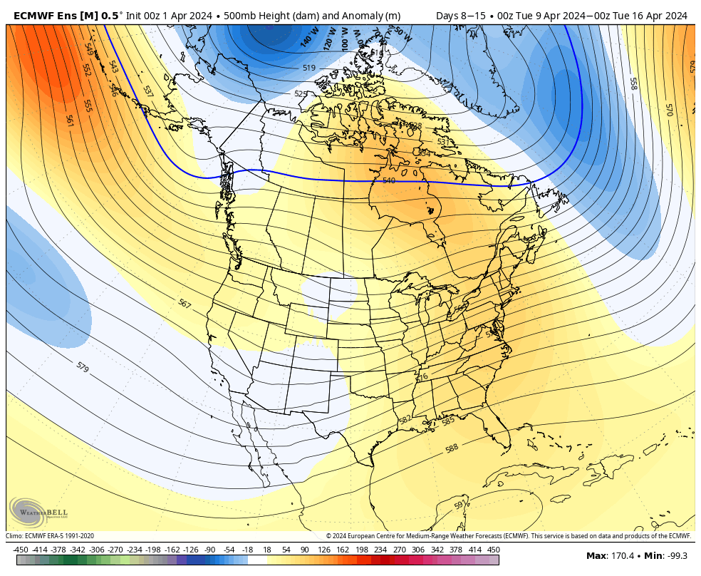
III. While we’ll briefly dry out in the 6-10 day, the pattern continues to present an active look down the road, including above normal rainfall projected in the Week 2 timeframe through the Plains and into the mid South and western Great Lakes region.
All in all, we don’t see any extended periods of dry weather on the horizon over the next few weeks as a whole.
Permanent link to this article: https://indywx.com/lunchtime-rambles-flooding-wind-whipped-snow-midweek-and-looking-ahead-to-an-opportunity-for-a-briefly-calmer-window/
There’s not much, if anything, to change regarding the setup and anticipated outcome of the Easter Sunday through Tuesday timeframe. Periods of heavy rain will get going Sunday PM and we’ll also need to watch for the threat of severe storms not only tomorrow afternoon/ evening but again Monday.
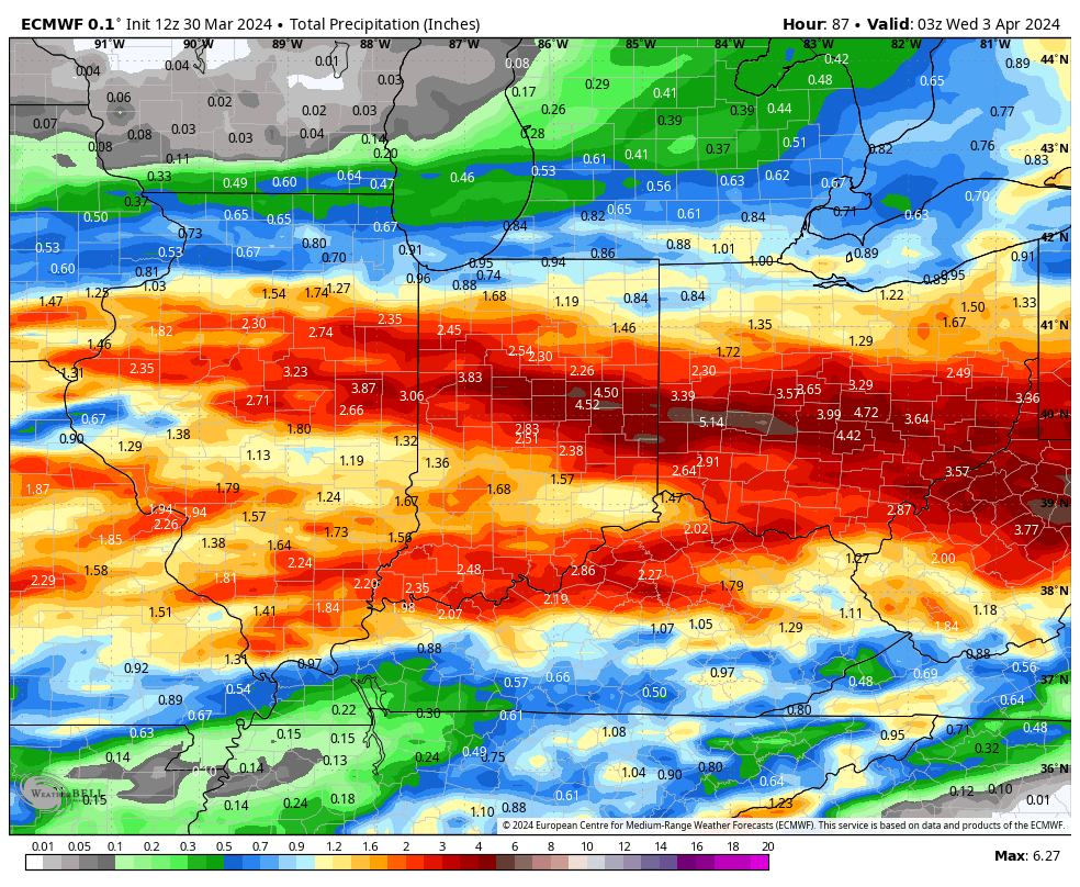
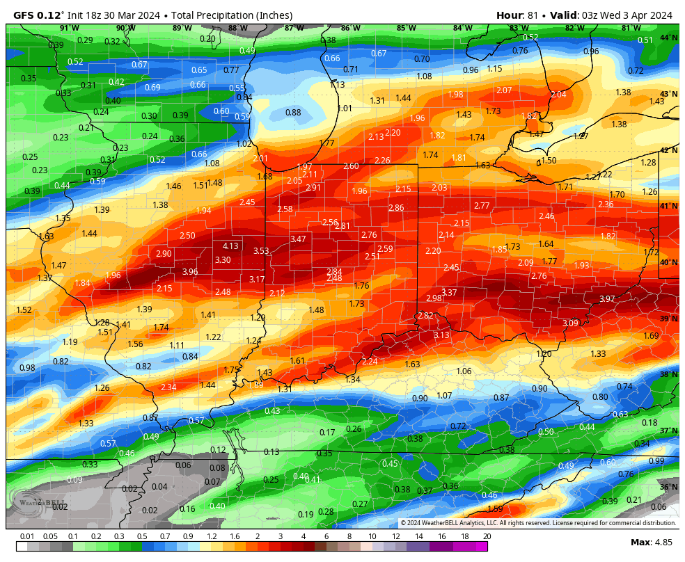
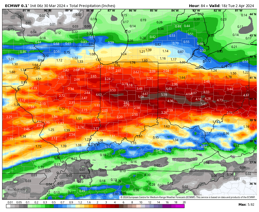
Midday models are latching onto a widespread 2”-4”+ event.
The Storm Prediction Center (SPC) has increased the threat area tomorrow afternoon. Large hail is greatest concern but an isolated tornado can’t be ruled out.
All modes of severe are on the table Monday, including tornado potential once again.
If all this wasn’t enough already, a much colder air mass will plunge into the region by midweek allowing rain to mix with and change to wet snow Wednesday evening into Thursday morning. The snow may even be heavy enough for slushy accumulations in spots.
Spring at its finest across the great Hoosier state…
The combination of a quasi-stationary frontal boundary, increasingly warm and humid air, and multiple waves of low pressure riding along the aforementioned boundary will lead to several rounds of locally heavy rain and also pose a strong to severe storm risk as we go through the early stages of the new week.
Precipitable water values (PWATs) will approach 1.5” to 2” at times early week (a tough feat to come by this time of year). This only raises confidence in the opportunity for this setup to generate periods of heavy, and eventually excessive, rainfall.
Widespread 3”+ totals can be expected by the time all is said and done, with locally heavier amounts.
If the heavy rain event wasn’t enough, we also need to be on guard for the threat of severe storms Sunday and Monday.
In particular, it’s Monday’s risk of severe that has us most concerned, including all modes (hail, wind, and a TOR threat). We recommend reviewing your family’s severe weather safety plan and make sure to have a way to receive any warnings that may be issued.
The heavy rain event will come to an end by Tuesday evening, but if we didn’t have enough to track already, we’ll add in the potential of rain to mix with wet snow Wednesday. Regardless, expect a much colder and blustery time of things as this bigger storm departs by midweek.