Significant weather alert day across central IN, including damaging wind potential and severe thunderstorms…
You must be logged in to view this content. Click Here to become a member of IndyWX.com for full access. Already a member of IndyWx.com All-Access? Log-in here.
What: All modes of severe weather, including tornadic potential. Damaging wind gusts.
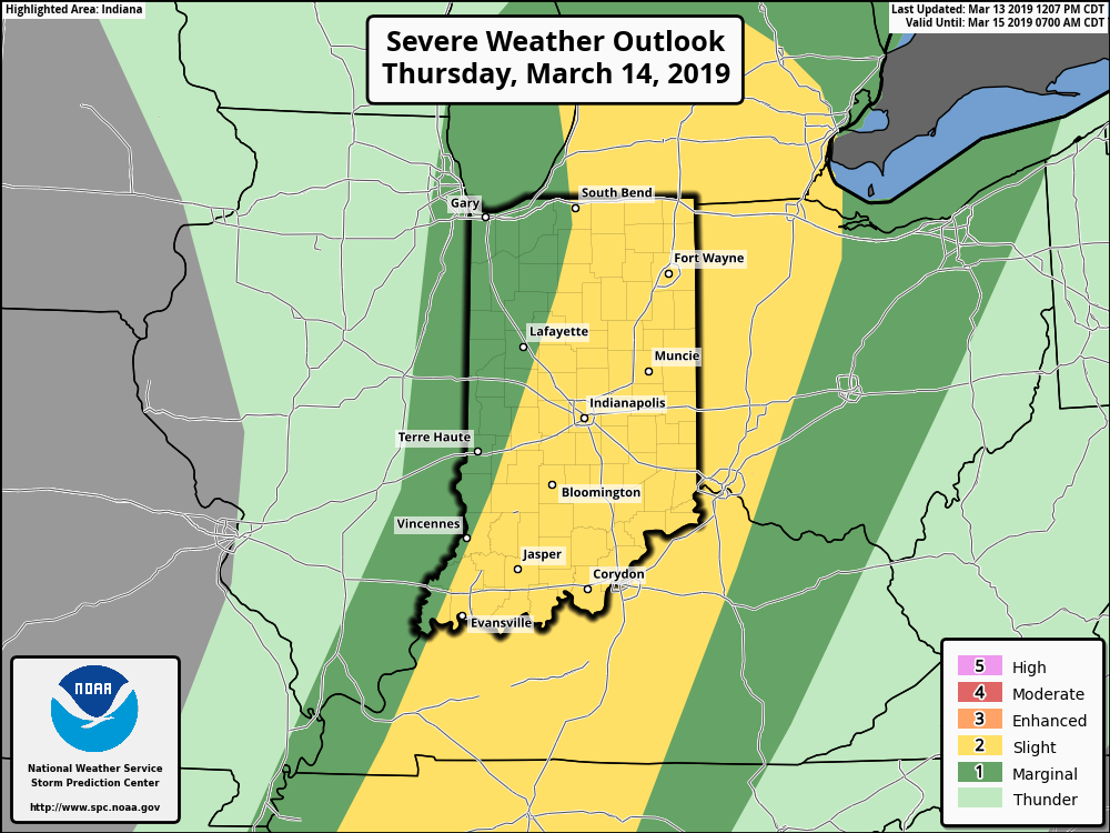
When: Damaging wind gusts develop late tonight into the predawn Thursday. Severe storms are most likely Thursday afternoon into early Thursday evening.
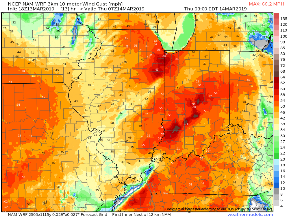
Wind: SW 45-55 MPH with gusts of 60 MPH+
Winds will begin to gust to potentially damaging levels during the overnight tonight.
A couple of rounds of thunderstorms will impact central Indiana during the overnight and again Thursday afternoon and evening. It’s the second round tomorrow afternoon that has us most concerned for the potential of strong to severe thunderstorms. A lot of this hinges on just how much clearing takes place from the morning round of showers and embedded thunder. Should we clear things out in significant fashion, and introduce some sunshine, the threat of severe weather tomorrow afternoon will grow significantly. Conversely, should we hold onto a mostly overcast sky, this will limit the overall severity of afternoon storms. The sun would help destabilize things in rather rapid fashion and given some of the other parameters in place, would lead to all modes of severe weather with storms that develop tomorrow afternoon- including large hail and tornadoes.
Additionally, due to the sheer strength of the storm system, damaging winds are still in play tomorrow (even outside of thunderstorms). In fact, winds will begin to gust upwards of 50 MPH+ during the overnight period tonight. If you haven’t already, please take the time now to tie down or secure loose objects to keep them from being blown about in the wind.
Conditions will begin to improve as early as tomorrow night, although we’ll turn much colder. Air will grow cold enough to promote “wrap around” moisture to fall in the form of snow by Friday afternoon.
Threat of strong to severe storms will be greatest Thursday afternoon into the early evening hours.
You must be logged in to view this content. Click Here to become a member of IndyWX.com for full access. Already a member of IndyWx.com All-Access? Log-in here.
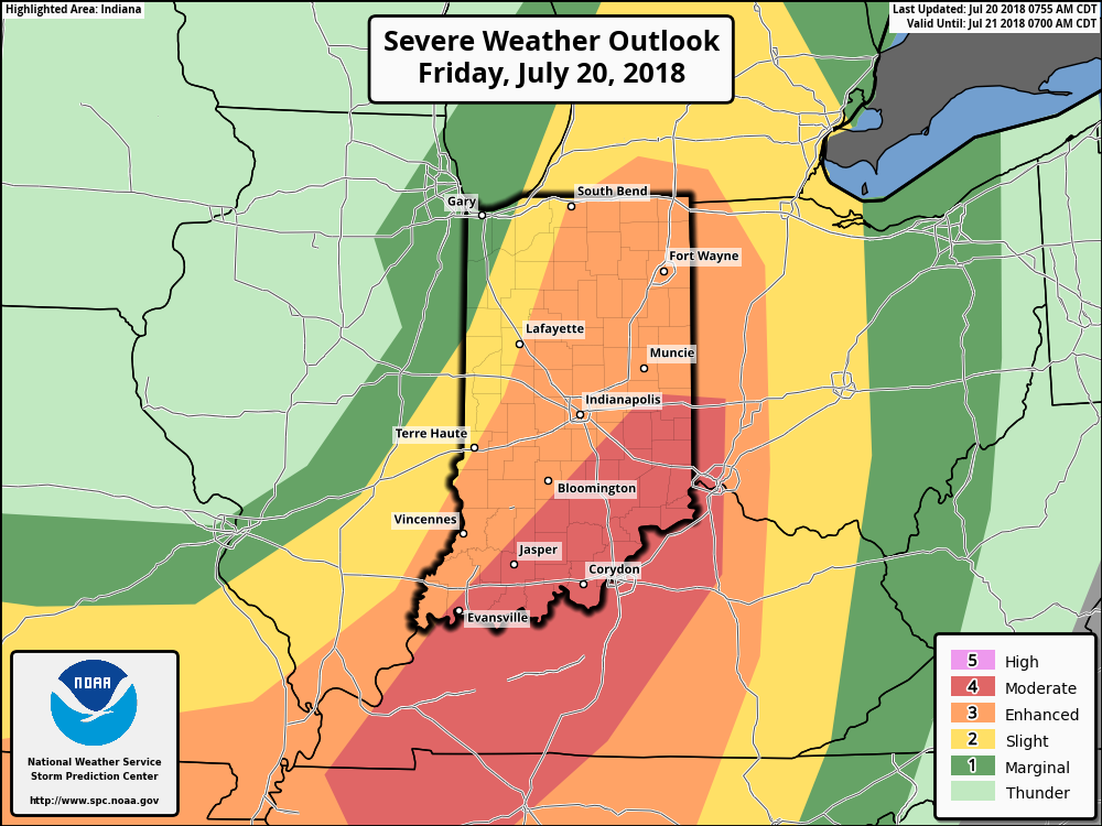
We continue to closely monitor the potential of severe weather this afternoon and evening across central and eastern portions of the state. The latest outlook from the Storm Prediction Center includes an ‘Enhanced’ risk for the majority of the state and has upgraded southeastern portions of the state into a rare ‘Moderate’ risk.
Part of the reason behind today’s severe weather has to do with an overall pattern shift. An intense short wave trough (especially for this time of year) will dig into the Great Lakes and Ohio Valley. At the surface, an area of low pressure will track from southern WI (this morning) before “cutting off” over the Ohio Valley this weekend. Additionally, a couple of frontal boundaries will swing through the state- the most potent being the boundary that surges east this afternoon and evening. The combination of ingredients spell trouble across at least a portion of the region- especially from Indianapolis and points south and east this afternoon and evening.
High resolution forecast radar products are likely struggling with handling the specifics today, but we think one or two lines of storms will track southeast across the state this afternoon and evening. The risk of severe weather will diminish from 7p to 8p from northwest to southeast across the state. Greatest concerns from a severe perspective include the potential of large, damaging hail and straight line winds. Additionally, a tornado or two can’t be ruled out. It’ll be important to remain weather-aware this afternoon and evening. Have a means of getting the latest information with respect to watches and warnings that may be issued later today from the National Weather Service.
As we look ahead, though the severe threat will end, unsettled times will remain this weekend. In fact, a couple of the stronger showers Saturday afternoon could contain hail (below severe levels), due to the cold air aloft associated with the upper low. Greatest coverage of showers this weekend will come during the afternoon and evening hours both Saturday and Sunday.
You must be logged in to view this content. Click Here to become a member of IndyWX.com for full access. Already a member of IndyWx.com All-Access? Log-in here.

 Part of the reason behind today’s severe weather has to do with an overall pattern shift. An intense short wave trough (especially for this time of year) will dig into the Great Lakes and Ohio Valley. At the surface, an area of low pressure will track from southern WI (this morning) before “cutting off” over the Ohio Valley this weekend. Additionally, a couple of frontal boundaries will swing through the state- the most potent being the boundary that surges east this afternoon and evening. The combination of ingredients spell trouble across at least a portion of the region- especially from Indianapolis and points south and east this afternoon and evening.