Quick video update on our thinking tonight, as well as a look at the weekend…
You must be logged in to view this content. Click Here to become a member of IndyWX.com for full access. Already a member of IndyWx.com All-Access? Log-in here.

Jan 28
Quick video update on our thinking tonight, as well as a look at the weekend…
You must be logged in to view this content. Click Here to become a member of IndyWX.com for full access. Already a member of IndyWx.com All-Access? Log-in here.
Permanent link to this article: https://indywx.com/wednesday-evening-thoughts-2/
Jan 27
Forecast models have been printing out wintry solutions for the upcoming weekend- particularly Saturday night through Super Bowl Sunday.
The GFS 500mb charts between 12z Monday and this morning show the key with this potential storm. Note the difference between yesterday (top) and today (bottom). The GFS model brings more energy out and the result is a stronger storm system.
 Timing between cold and moisture associated with storm systems has been the important missing link this winter with bigger storms. Does that trend continue this weekend? Snow lovers hope not…
A key ingredient that has been missing in the past is a big area of high pressure north of the region supplying cold air as surface low pressure tracks in a favorable position for wintry precipitation. Models do suggest not only renewed arctic high pressure building down the Plains region Sunday into Monday, but also a 1040mb high over the northern Lakes region. This would help go a long way in keeping cold air flowing into the region.
What about the sensible weather here?! Keeping in mind that this is still an event 5 days out….. The GFS model suggests mostly a snow event north-central, but also brings in a wintry mix of icy precipitation and rain across the southern half of the state. The Canadian forecast model (not shown here) is more suppressed and leads to an accumulating weekend snow event across the region and targets southern portions of the state for heaviest snowfall. The European model is the most “ideal” scenario for central Indiana snow lovers and leads to a significant snow event across the heart of the state.
Note the European forecast model track a wave of low pressure in an ideal location for heavy snow across central Indiana before intensifying and hammering the Northeast region.
We’ll continue to keep a close eye on this developing situation. Stay tuned….
Permanent link to this article: https://indywx.com/keeping-an-eye-on-the-weekend/
Jan 22
The past 5-7 days have featured a common “January thaw-” something typically seen in even the coldest Januarys. The coming 5-7 days will see a “step down” process of colder weather, interrupted by a day or two of milder southwest breezes. In the longer range, we hold firm on the idea of more sustained cold, and potentially frigid air, setting up shop to open February.
See the GFS track the clipper through the lower lakes this weekend. This is a mild track for central Indiana and will keep the accumulating snows over the Lakes region, extending into northern portions of the state. Some light snow will fly here late Sunday night/ early Monday, but accumulations should be minimal.
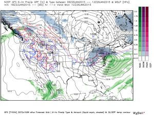 A brief surge of arctic air will invade early next week and may be accompanied by light snow Tuesday.
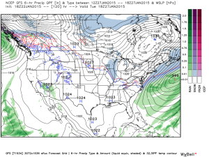 A brief southwesterly flow will allow milder air into the region by the middle of next week, but we caution this will be brief.
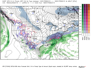
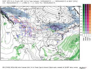 Much colder times loom to open February, potentially with a winter storm. Obviously with this being in the 8-10 day period, there will be a lot of time to watch the storm potential. Models have struggled mightily with storms this winter so far. We’re much more confident on the cold, and potentially downright frigid air at that (still don’t think we’ve seen the coldest air of the winter yet). Note the GFS sees the arctic highs “lining up.”
 The European ensembles and operational are also keying in on the cold and wintry pattern closing January and to open February:
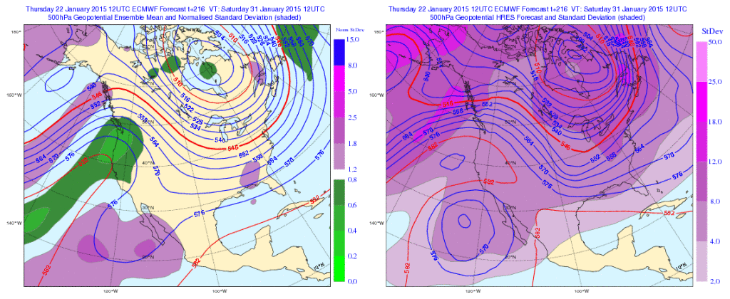 Initially the cold attacks the northeastern portions of the country, but “backs” west with time in the longer range:
Days 5-10
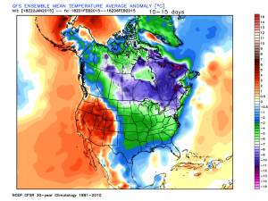 The NAEFS and CFSv2 see the colder pattern returning:
We still think there’s a lot of “winter” left in the coming months. Many folks enjoy snow Christmas into January, but begin to crave spring in February and March. This is the type pattern that can be quite “ugly” for spring lovers as colder and snowy weather can push well into the spring months… (Noted that we still have a lot of catch up to do in the snow department, but we’re not ready to say we won’t make up for “lost time”).
Permanent link to this article: https://indywx.com/step-down-process-to-cold-before-the-return-of-truly-frigid-times/
Jan 16
I’m blessed to have family in town this weekend so posts will be a bit off schedule the next few days, but keep it tuned here as they will come!
What a remarkable January this is as temperatures are averaging more than 9 degrees (fahrenheit) below average AND COLDER than last January. While I know snow lovers are wanting more snow (yours truly included), one has to sit back and really appreciate the pattern for what it is from a cold standpoint. I would go as far as to argue this pattern is actually more impressive than last January as the cold has come in the face of what’s been a much less impressive snow pack (for the most part).
Despite a brief “relaxation” now, models suggest the cold comes on like gangbusters yet again to wrap up the month. Given where we’ve been and what appears to lie ahead, it would seem as if this January will be even colder than last January- not only through the first half, but at month’s end. It’ll be fascinating to watch unfold.
Speaking of snow, I still believe this is the type pattern that can “flip on a dime” in the snow department. The sea surface temperature profile and analogs at least suggest we’re on the playing field for a stormy ride through the month of February and even into March this year. Does it mean it has to be a snowy pattern? No, but at this distance it’s at least nice knowing we’re on the field with a chance to win the game.
In the shorter term, a windy “mild up” will occur Saturday as highs reach the middle to upper 40s with a gusty southwest wind in play. Winds will top 30-40 MPH so you’ll definitely want to “batten down the hatches” Saturday.
Permanent link to this article: https://indywx.com/friday-morning-thoughts/
Jan 14
Enjoy our relatively quiet and briefly milder weather pattern as mid and long range guidance suggests we reload the cold with authority and associated wintry precipitation threats…
You must be logged in to view this content. Click Here to become a member of IndyWX.com for full access. Already a member of IndyWx.com All-Access? Log-in here.
Permanent link to this article: https://indywx.com/relatively-quiet-now-but-it-wont-last-long/