
You must be logged in to view this content. Click Here to become a member of IndyWX.com for full access. Already a member of IndyWx.com All-Access? Log-in here.
Category: Freezing Rain
Permanent link to this article: https://indywx.com/video-brief-thaw-gives-way-to-a-wintry-close-to-the-week/
Jan 09
Brief Thaw; Severe Winter Event Looms For A Portion Of The Region…
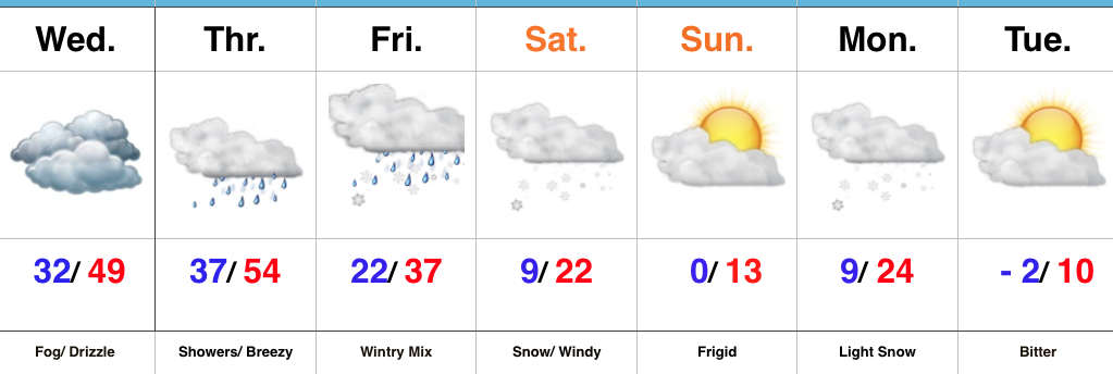 Highlights:
- Fog and drizzle
- Major winter storm looms
- Frigid air returns
Brief Thaw; Major Winter Storm On Deck…The short-term will be dominated by low clouds and areas of fog, along with patchy drizzle. Areas of freezing fog and drizzle are possible early Wednesday morning before conditions “warm” in earnest through the afternoon and evening.
A cold front will approach from the northwest Thursday with showers and gusty southerly winds. This southerly air flow will deliver a briefly milder time of things during the day Thursday before the cold front settles south Thursday night. As this transpires, surface low pressure will organize along the southern end of the boundary before tracking northeast into the Tennessee and Ohio Valley Friday into Saturday.
We continue to favor a track up west of the spine of the Appalachians and note some of the more progressive data is beginning to correct west to align closer with the other guidance that’s been spitting out big snow numbers over the past few days. Before we discuss snow, an icy mixture of sleet and freezing rain will fall across the region late Thursday night into early Friday. We expect precipitation to transition to all snow Friday afternoon, continuing into Saturday. At times, heavy snow is likely.
While we aren’t ready to lay out an accumulation map just yet, the heaviest snow axis will likely include 8″ to 12″+ amounts somewhere through central portions of the state. We’ll aim to provide a first call snowfall map this time tomorrow. Furthermore, there will also be a wind component to this storm. What’ll initially be a wet, heavy snow will turn more “powdery” in nature as arctic air gets pulled into the storm. That powder will get blown and drifted about Friday night and Saturday and travel will be significantly impacted.
Frigid conditions will return over the weekend before another accumulating snow pushes into town Monday. Behind this snow maker, a brutal push of sub-zero air is likely next week.
Upcoming 7-Day Precipitation Forecast:
- Snowfall: 6″+
- Rainfall: 0.50″ to 0.75″
Permanent link to this article: https://indywx.com/brief-thaw-severe-winter-event-looms-for-a-portion-of-the-region/
Jan 07
VIDEO: Icy, Snowy Night Ahead; Late Week Winter Storm?
You must be logged in to view this content. Click Here to become a member of IndyWX.com for full access. Already a member of IndyWx.com All-Access? Log-in here.
Permanent link to this article: https://indywx.com/video-icy-snow-night-ahead-late-week-winter-storm/
Jan 07
Busy, Busy, Busy…
 Highlights:
- Messy wintry mix arrives tonight
- Briefly milder midweek
- Potential storm brewing Friday
Snow And Ice Arrive Tonight…Clouds will lower and thicken across the state as we progress through the day. We’ll also note a stiff easterly breeze as an approaching storm system inches ever so much closer. This storm system will spread a wintry mix through the state tonight into early Monday morning. Initially, we think most of central Indiana will deal with snow before a transition to freezing rain during the overnight, continuing into Monday morning. Before the transition, 1″ to 2″ of snow seems to be the best idea before an icy glaze develops atop the freshly fallen snow. Based on the expected transition to freezing rain, there’s an opportunity for up to a tenth of an inch of freezing rain. That said, we’ll have to keep a very close eye on temperature profiles this evening as even the difference of a couple of degrees aloft can make all the difference in a faster or slower transition to freezing rain. Expect the Monday morning commute to be heavily impacted.
Colder air will push back in here Monday evening into Tuesday with considerable cloudiness remaining. A milder southerly flow will overtake the region Wednesday into Thursday. Low clouds and fog along with drizzle will develop Wednesday and we may have to deal with a touch of freezing drizzle early in the day before temperatures rise. A spike in temperatures will take place Thursday, briefly sending central Indiana into the 50s before a cold front slides through the state Thursday evening.
An area of low pressure will develop along the southern end of the frontal boundary and lift northeast into the TN Valley and eastern Ohio Valley Friday. As colder air presses into the region, precipitation will change from a wintry mix of sleet and freezing rain to all snow through the day Friday. It’s far too early to get specifics around accumulation ideas, but this storm has potential to be significant. Much colder air will whip in here next weekend.
Upcoming 7-Day Precipitation Forecast:
- Snowfall: 2″ – 4″
- Rainfall: 0.50″ – 0.75″
Permanent link to this article: https://indywx.com/busy-busy-busy/
Jan 06
Frigid Saturday Gives Way To A Messy Sunday Evening…
 Highlights:
- Bitter cold eases
- Mix of snow and ice
- Milder midweek
Bitter Today; Wintry Mix By Sunday Evening…Most central Indiana reporting sites are checking in this morning between 6° and 10° below zero, but we note a couple of spots are even colder. Arctic high pressure will remain in control of our weather today, leading to sunny and bitter conditions.
An approaching storm system Sunday will help increase our cloud cover through the morning and we expect snow to develop by evening. As warmer air aloft works into the region, a transition to freezing rain is expected during the overnight into early Monday morning. The morning commute looks very messy Monday.
Moderating temperatures will develop by midweek and as the milder air moves over the cold surface, thick fog and areas of drizzle and light rain will develop Wednesday. A cold front will sweep through the state Thursday with showers and we’re keeping close tabs on a secondary piece of energy that will lead to a wintry close to the work week for portions of the Ohio Valley. In fact, a significant winter event should develop out of this pattern Friday into Saturday. The early call for now is that this is east of our region, but stay tuned. Snow showers will fly in the colder air to close the week regardless.
Upcoming 7-Day Precipitation Forecast:
- Snowfall: 1″ – 2″
- Rainfall: 0.50″ – 0.75″
Permanent link to this article: https://indywx.com/frigid-saturday-gives-way-to-a-messy-sunday-evening/