You must be logged in to view this content. Click Here to become a member of IndyWX.com for full access. Already a member of IndyWx.com All-Access? Log-in here.
Category: Freezing Rain
Permanent link to this article: https://indywx.com/video-update-on-the-wintry-conditions-that-are-inbound/
Nov 14
First Winter Storm System Of The Season…
You must be logged in to view this content. Click Here to become a member of IndyWX.com for full access. Already a member of IndyWx.com All-Access? Log-in here.
Permanent link to this article: https://indywx.com/first-winter-storm-system-of-the-season/
Mar 22
Significant Weekend Winter Storm…
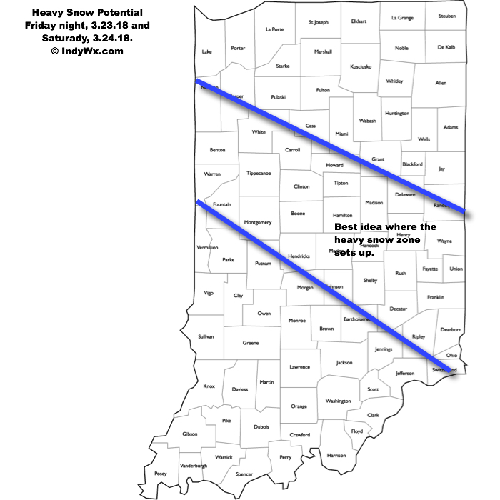
A significant winter storm will impact the heart of the state Friday night into Saturday evening. The National Weather Service has already hoisted Winter Storm Watches, and for good reason, as significant impacts are expected from this system, including in and around the Indianapolis area.
An area of low pressure will track off the lee of the Rockies Friday morning, central Plains Friday afternoon, and southeastern Illinois Saturday morning. A tight thermal gradient will result in temperatures into the lower 70s just to the south of the track, while areas north of the low remain around freezing, including central Indiana. This gradient will also support banding features and incredibly heavy snowfall rates late Friday night and Saturday within the heavy snow zone. Snowfall rates of 1″ to 2″ per hour are possible, leading to very difficult travel Saturday, and total accumulations in the range of 6″ to 10″. Add in a gusty wind over 30 MPH and you have the makings for a day that’s best served off the roads and indoors Saturday.

Just south of where the heaviest band of snow sets up, a period of sleet and freezing rain is also possible before a cold rain falls far downstate. Precipitation will end from northwest to southeast Saturday night and the weekend will wrap up dry Sunday- when the heart of the state will be digging out from a significant snow event. We’ll continue to keep a close eye on things.
Permanent link to this article: https://indywx.com/significant-weekend-winter-storm/
Mar 19
Wet Snow Event For East-Central Indiana…
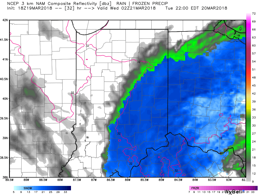
Moisture will overspread the southern half of the state as we progress through the evening. Expect an increasingly damp time of things, especially from the I-70 corridor and points south through the overnight period. Eventually, as cold air oozes south, precipitation will become mixed with a wintry “cocktail” of sleet, freezing rain, and wet snow along the I-70 corridor during the overnight into the predawn hours Tuesday.
 While major travel problems aren’t expected, a slushy accumulation is possible along the I-70 stretch early Tuesday morning.
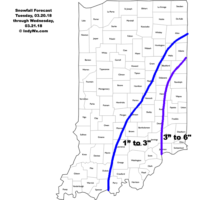
We’ll be in between systems and undergo a bit of a lull in the action during the majority of the daytime hours Tuesday. However, as upper level energy spins closer to the region, we’ll notice an expanding area of snow that will initially develop across south-central parts of the state Tuesday afternoon before encompassing eastern portions of the region Tuesday evening. During this time period, snowfall intensity will also begin to ramp up and we fully expect periods of wet heavy snow to fall through the nighttime into Wednesday morning across eastern Indiana.
 Our initial first-stab at accumulations includes a band of 3″ to 6″ amounts across far eastern parts of the state, and it’s within this zone that we’ll likely see a few 6″+ reports before things begin to wind down late Wednesday morning into the early afternoon. Somewhere between New Castle and Richmond very well may end up being the winner with this event.
 Given the unseasonably cold March ongoing, along with expected snowfall intensity, accumulation on roadways and travel problems are expected to develop Tuesday night into Wednesday morning across eastern Indiana. We recommend having travel completed before sunset Tuesday evening if your travels take you to, or through, far eastern Indiana.
As we’ve stated, March snow events always have “surprises.” While we try our best to eliminate as many of these surprises as possible, it’s simply the nature of the beast this time of year. Early spring snow events are notorious for producing localized intense bands of snow (more so than even high resolution models can show) given the right dynamics and time of day. Just something to keep in mind as we progress through the upcoming 24 to 48 hours.
Permanent link to this article: https://indywx.com/wet-snow-event-for-east-central-indiana/
Mar 19
VIDEO: Accumulating Snow Impacts Parts Of The Area Tuesday-Wednesday…
You must be logged in to view this content. Click Here to become a member of IndyWX.com for full access. Already a member of IndyWx.com All-Access? Log-in here.
Permanent link to this article: https://indywx.com/video-accumulating-snow-impacts-parts-of-the-area-tuesday-wednesday/
