Category: Forecast

Wednesday Video Update

This morning’s video discusses rain and storm chances late tonight and again late Thursday night.  We also talk about a big storm brewing for later this weekend into next week.…

You must be logged in to view this content. Click Here to become a member of IndyWX.com for full access.  Already a member of IndyWx.com All-Access?  Log-in here.

Permanent link to this article: https://indywx.com/2014/04/23/wednesday-video-update/

Beautiful Easter Sunday!

Easter

Mon.

Tue.

Wed.

Thr.

Fri.

Sat.

 Status-weather-clouds-icon

 Status-weather-showers-day-icon

 Status-weather-showers-day-icon

 Status-weather-clouds-icon

 Status-weather-clouds-icon

 Status-weather-showers-day-icon

 Status-weather-showers-day-icon

43/ 72

50/ 74

42/ 59

35/ 58

43/ 68

53/ 74

54/ 69

– – –

Light

Light

– – –

– – –

Light

Light

Custom IndyWx.com Forecast Updated 04.19.14 @ 10:11p

Our beautiful weekend will continue for Easter Sunday, thanks to high pressure. Another cool start will warm nicely under a mostly sunny to partly cloudy sky.

The next weather maker to impact central Indiana will arrive late Monday evening into early Tuesday.  A cold front will swing through the area and be responsible for scattered showers.  Most of Monday will be rain-free, but rain chances will be on the increase Monday night through Tuesday morning.  All-in-all, this won’t be a big rain event with most neighborhoods only accumulating a tenth to quarter inch of rain as the front swings through.

Cooler air will build into the region through mid week as dry conditions return.

Our next weather maker is still slated for a weekend arrival, including the threat of thunderstorms Friday and showers Saturday.  We’ll fine tune details around timing as we move forward, but a potentially much cooler air mass may settle into the region Saturday night into next Sunday.

Upcoming 7-Day Precipitation Forecast:

  • 7-Day Rainfall Forecast: 0.50″ – 0.75″
  • 7-Day Snowfall Forecast: 0.00″

twicKeep Up With IndyWx.com On The Go!  Follow Us On Twitter @indywx or become a Friend of ours on Facebook- IndyWx.com

images

Permanent link to this article: https://indywx.com/2014/04/19/beautiful-easter-sunday/

Thursday Evening Update…

Rain chances continue to look less and less impressive tomorrow morning.  All-in-all, similar to last weekend, we’re expecting a beautiful time of things across the region going into the Easter…

You must be logged in to view this content. Click Here to become a member of IndyWX.com for full access.  Already a member of IndyWx.com All-Access?  Log-in here.

Permanent link to this article: https://indywx.com/2014/04/17/thursday-evening-update/

Beautiful Until Monday With A Small “Speed Bump” Friday.

Thr.

Fri.

Sat.

Easter

Mon.

Tue.

Wed.

 Status-weather-clouds-icon

 Status-weather-showers-day-icon

 Status-weather-clouds-icon

 Status-weather-clouds-icon

 Status-weather-showers-scattered-icon

 Status-weather-clouds-icon

 Status-weather-clouds-icon

32/ 63

46/ 62

38/ 63

41/ 70

52/ 69

47/ 66

36/ 65

– – –

Light

– – –

– – –

Light

– – –

– – –

Custom IndyWx.com Forecast Updated 04.17.14 @ 7:57a

Wednesday was a step in the right direction.  After a frigid start to the day, temperatures responded to that powerful mid-April sun.  We’ll continue to climb today with partly cloudy skies and winds backing around to the southwest.  

The southwest flow will aid in moisture transport north. We’ll increase our cloud cover this evening and add scattered showers into your forecast Friday morning. Most rain should fall during the morning hours with diminishing showers during the afternoon and clearing taking place Friday night.  All in all, Friday’s rain maker won’t be a big deal.

This will set the stage for a beautiful weekend, including lower to middle 60s Saturday and near 70 Easter Sunday. Sunshine will dominate both days!  Simply perfect weather for those Easter Egg hunts, but you may need a jacket during Easter Sunrise services.

Our next storm system approaches Monday and will result in a period of steady rains and an embedded rumble or two of thunder.

We’ll quickly dry things out again next Tuesday and Wednesday.

Upcoming 7-Day Precipitation Forecast:

  • 7-Day Rainfall Forecast: 0.50″ – 0.75″
  • 7-Day Snowfall Forecast: 0.00″

twic

Keep Up With IndyWx.com On The Go!  Follow Us On Twitter @indywx or become a Friend of ours on Facebook- IndyWx.com

images


Permanent link to this article: https://indywx.com/2014/04/16/beautiful-until-monday-with-a-small-speed-bump-friday/

Slow Moderation…

Wed. Thr. Fri. Sat. Easter Mon. Tue.               27/ 50 35/ 62 45/ 60 32/ 56 37/ 65 50/ 62 46/ 65 – –…

You must be logged in to view this content. Click Here to become a member of IndyWX.com for full access.  Already a member of IndyWx.com All-Access?  Log-in here.

Permanent link to this article: https://indywx.com/2014/04/15/slow-moderation/

Old Man Winter Isn’t Finished

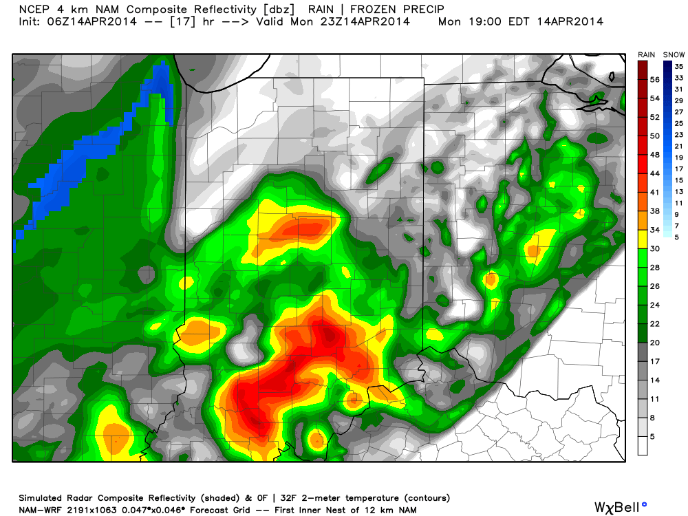
Come this afternoon it’ll be tough to believe we were in the 70s over the weekend!  A cold front is moving through central Indiana this morning and resulting in showers.  Rain will continue in an off-and-on fashion today, becoming a bit more organized yet again later this afternoon and evening.  This will be in response to a wave of low pressure developing to our east, along the pressing strong cold front.

A look at the forecast simulated radar at 7pm this evening:

1

MUCH colder air will pour into the region today, complete with gusty northwest winds.  In fact, we’ll be in the 40s just after the lunchtime hour and the free-fall will continue.  30s arrive this evening and rain will begin to transition to wet snow.  Not all will see accumulation tonight, but a slushy accumulation of around half an inch will be possible where heavier snow persists.

A look at the forecast simulated radar towards 11pm-12am:

23

Temperatures will crash into the 20s by Tuesday morning.  I saw many folks at Lowes buying flowers yesterday…hopefully those folks aren’t planning on planting until later…

4

Tuesday will feature clearing skies, albeit unseasonably cold conditions.  We’ll remain in the 30s most of Tuesday, struggling to make it much above 40 by afternoon, along with a chilly northwest wind in place.  Lows Tuesday night/ Wednesday morning will drop into the lower to middle 20s.

Permanent link to this article: https://indywx.com/2014/04/14/old-man-winter-isnt-finished/

From 76 Today To Snow Monday Night…

Today will be a beauty of a day- partly to mostly cloudy, windy, and warm.  We’re forecasting an official IND high of 76.  Clouds thicken this evening and showers and…

You must be logged in to view this content. Click Here to become a member of IndyWX.com for full access.  Already a member of IndyWx.com All-Access?  Log-in here.

Permanent link to this article: https://indywx.com/2014/04/13/from-76-today-to-snow-monday-night/

Warm Weekend On Tap

Sat.

Sun.

Mon.

Tue.

Wed.

Thr.

Fri.

 Status-weather-clouds-icon

 Status-weather-showers-day-icon

 Status-weather-storm-night-icon

 Status-weather-clouds-icon

 Status-weather-clouds-icon

 Status-weather-clouds-icon

 Status-weather-showers-day-icon

43/ 75

59/ 76

42/ 66

31/ 42

28/ 50

32/ 62

44/ 60

– – –

Light

Light

– – –

– – –

– – –

Light

Custom IndyWx.com Forecast Updated 04.12.14 @ 8:16a

Warm Spring Weekend. . .After a chilly start to your Saturday, temperatures will quickly warm on a developing southerly breeze and that powerful April sunshine.  We note that moisture will begin to increase through the afternoon and evening hours and this may help trigger a widely scattered shower.  That said, the majority of neighborhoods will remain dry and rain-free today.  Enjoy what will be a beautiful spring day!

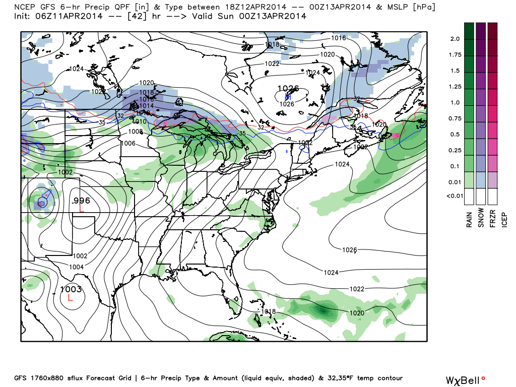
Strong southwest winds will howl Sunday, but the majority of the day will be dry and include a partly to mostly cloudy sky.  A passing shower is possible during the day, but, similar to Saturday, most will remain rain-free.  Better rain and storm chances will arrive late Sunday night into Monday.

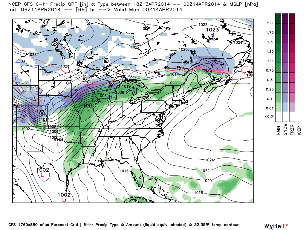
Cold Frontal Passage. . .A cold front will move through the region Monday.  Ahead of this boundary, widespread showers and embedded thunderstorms will rumble through the area late Sunday night into Monday.  Today’s model data has trended downward on rainfall numbers and our forecast will follow suit.  We forecast anywhere from one half to three quarters of an inch of rain with this system.

Colder Air Moving In. . .A much colder air mass will pour in on a gusty northwest breeze Monday evening and Tuesday.  Temperatures will run close to 20 degrees below normal Tuesday and a hard freeze is ahead for Wednesday morning.

Moderating Back To Seasonal Levels. . .Temperatures will quickly begin to moderate by mid to late week as we get back into a milder southwesterly air flow.  We’ll introduce shower chances back into your forecast next Friday as the next weather system draws closer to our region.

Upcoming 7-Day Precipitation Forecast:

  • 7-Day Rainfall Forecast: 0.75-1″
  • 7-Day Snowfall Forecast: 0.00″

twicFor weather updates and more “behind the scenes” data on the go, be sure to Follow Us on Twitter @indywx or become a Friend of IndyWx.com on Facebook!

images

Permanent link to this article: https://indywx.com/2014/04/11/warm-weekend-on-tap/

Friday Evening Weather Update!

What a pleasant evening underway!  Get out there and enjoy it!  More details about what lies ahead can be found in the video below…

You must be logged in to view this content. Click Here to become a member of IndyWX.com for full access.  Already a member of IndyWx.com All-Access?  Log-in here.

Permanent link to this article: https://indywx.com/2014/04/11/friday-evening-weather-update/

The Weekend Is Here!

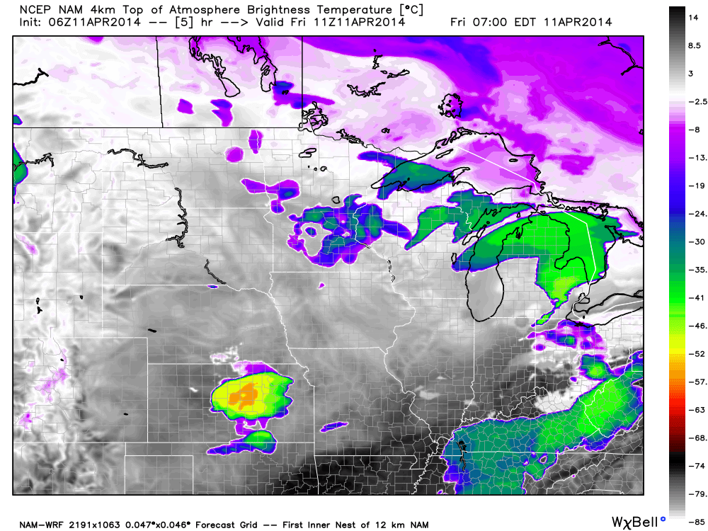
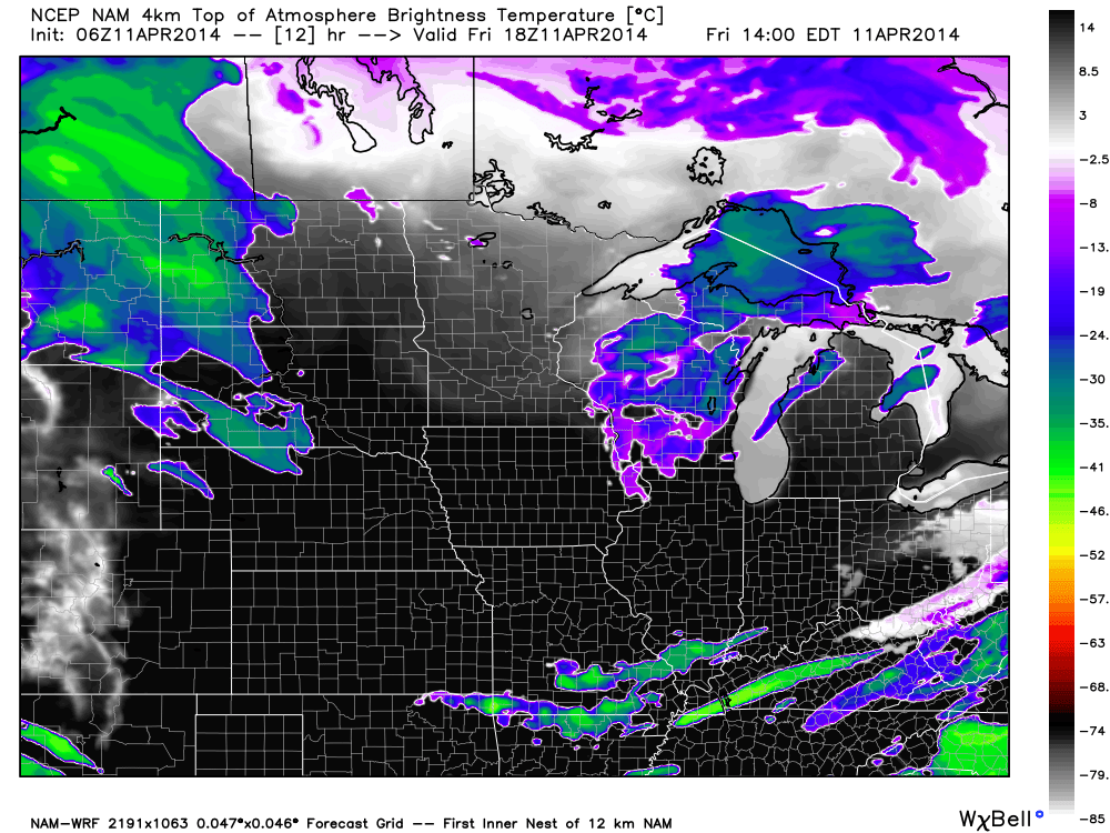
After a few clouds this morning, we’re looking at increasing sunshine as we progress through the day.  Simulated satellite shows this well.

7am forecast satellite

1

2pm forecast satellite

2

Thankfully, this is a sign of things to come and a very nice (and warm) weekend is on tap!

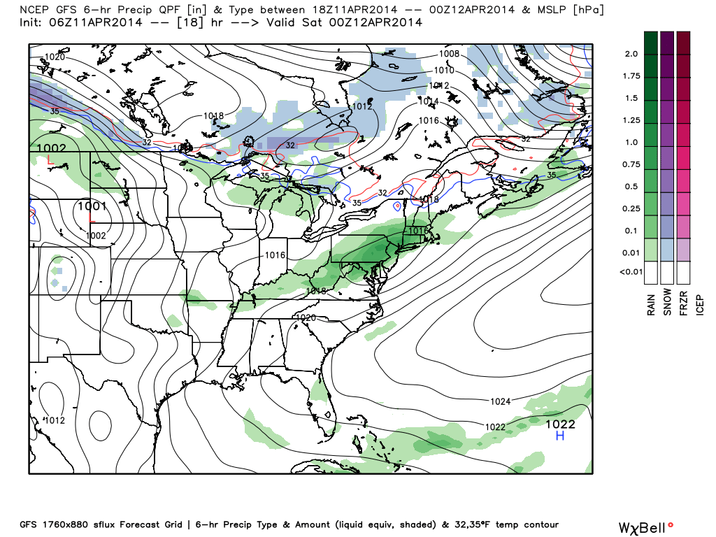
High pressure will build in through the day, helping skies turn increasingly sunny.  A north breeze will keep temperatures cooler today than yesterday’s official downtown high of 74.

3

Most of Saturday will be dry and feature partly cloudy skies, but clouds will develop and a widely scattered shower will be possible during the afternoon and evening as moisture begins to increase.  Most will stay dry Saturday, however.

4

Sunday will be a windy and warm day, but with partly cloudy and dry conditions for the better part of the day.  Heavier rain and strong storms will develop to our west Sunday, but it’s really not until Sunday night into Monday when our immediate region will deal with this rainy and stormy weather.

5

  • Friday: Increasing sunshine; 65
  • Saturday: Partly cloudy; widely scattered PM shower; 43/ 71
  • Sunday: Partly cloudy and windy; developing nighttime rain/storms; 59/ 73

Permanent link to this article: https://indywx.com/2014/04/11/the-weekend-is-here/

IndyWx.com