Category: Forecast
Good morning and happy Friday, Hoosiers! The region will remain under the influence of a swirling upper level low as we put a wrap on the work week. This will keep chilly, unsettled weather in our forecast. Temperatures will remain below normal through the weekend, though begin to moderate from the ridiculously chilly readings of late week.
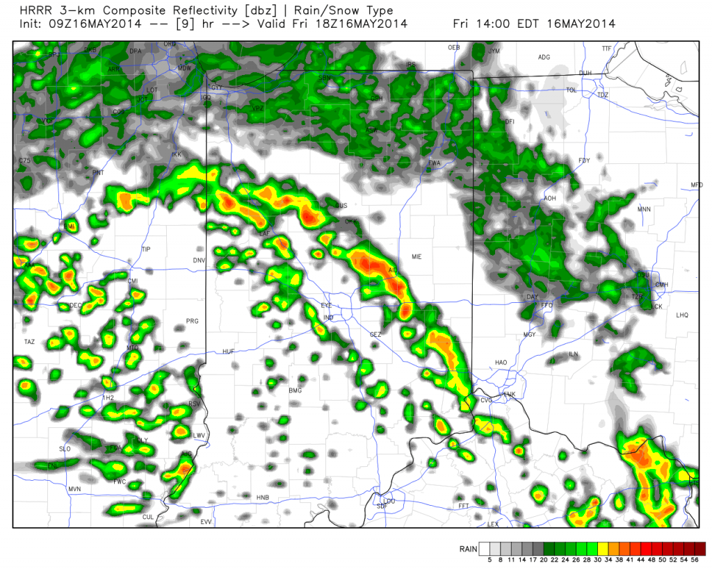
We’re dealing with showers around the area now, but showers will intensify this afternoon and with all of the cold air aloft could easily produce small hail. Here’s a look at forecast radar early this afternoon- 2pm.

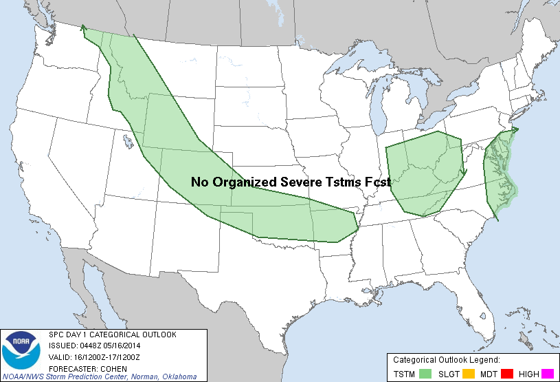
The Storm Prediction Center (SPC) highlights the region for the possibility of small hail.

The other huge story will be the very cold temperatures tonight into Saturday. In fact, we wouldn’t be surprised to hear reports of light frost in outlying areas Saturday morning with forecast lows in the mid 30s! Sunshine will increase as we progress through the weekend and temperatures will respond, albeit slowly! We’ll take what we can get!
- Friday: Mostly cloudy, scattered showers and thunderstorms (some stronger storms could produce small hail), 41/55
- Saturday: Cold start to the day! Increasing sunshine, still a possible light shower, 35/59
- Sunday: Partly cloudy and nice! 38/64
Permanent link to this article: https://indywx.com/2014/05/16/weekend-look-hail-producing-showers-storms-this-afternoon/
Many central Indiana neighborhoods are still in the 40s as of this update. Officially, the high so far today at IND has reached 50 and is more than 20 degrees below where we should be for this date.
The upper low continues to swirl over Iowa this afternoon and will help push a band of showers into central Indiana during the wee morning hours Friday. Additionally, the threat is there that a couple of the stronger showers Friday afternoon include some small hail with added instability and the very cold air aloft.

As we look ahead to the second half of May, don’t be surprised by a repeat performance in this weather pattern. We think brief ridging will be responsible for highs above the 80 degree mark the middle of next week, but the stage may be set for another stretch of unseasonably cool air to wrap up the month…. Additional details can be found in the video!
Permanent link to this article: https://indywx.com/2014/05/15/thursday-evening-update-repeat-in-the-pattern-coming-to-end-may/
|
Thr.
|
Fri.
|
Sat.
|
Sun.
|
Mon.
|
Tue.
|
Wed.
|
|

|

|

|

|

|

|

|
|
42/ 51
|
38/ 52
|
36/ 58
|
37/ 63
|
41/ 67
|
52/ 70
|
60/ 80
|
|
Light
|
Light
|
Light
|
– – –
|
– – –
|
Light
|
– – –
|
We’re locked into a cloudy, raw, and wet weather pattern and there’s no let up until later into the upcoming weekend. A big upper low is positioned across Iowa this morning and will remain the primary driver in our weather here through Saturday. Unseasonably chilly conditions, gusty northwest winds, and periods of drizzle and rain can be expected through the period. We’ll finally begin to shake the clouds and rain, but unseasonably cool air will linger into early next week. As for the pick of the weekend, it still easily appears to be Sunday, with mostly dry conditions, increased sunshine, and moderating temperatures. An additional one half to three quarters of an inch of rain will be possible between today and Saturday. Warmer times are ahead early next week as a warm front blows through the area with a possible shower or storm Tuesday.
Permanent link to this article: https://indywx.com/2014/05/15/raw-and-chilly/
The remainder of the work week will feature plenty of rain and well below normal temperatures.
A surface wave will move up along a cold front today into Thursday and be responsible for widespread rain, some of which will be heavy, across central Indiana. Additionally, severe thunderstorms, including possible quick spin-up tornadoes, will be possible across far eastern Indiana and Ohio this afternoon and evening.
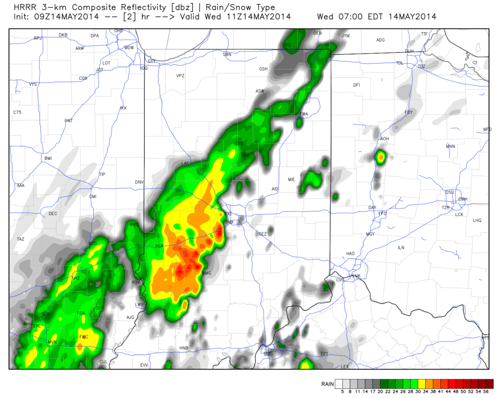
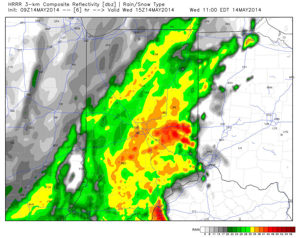
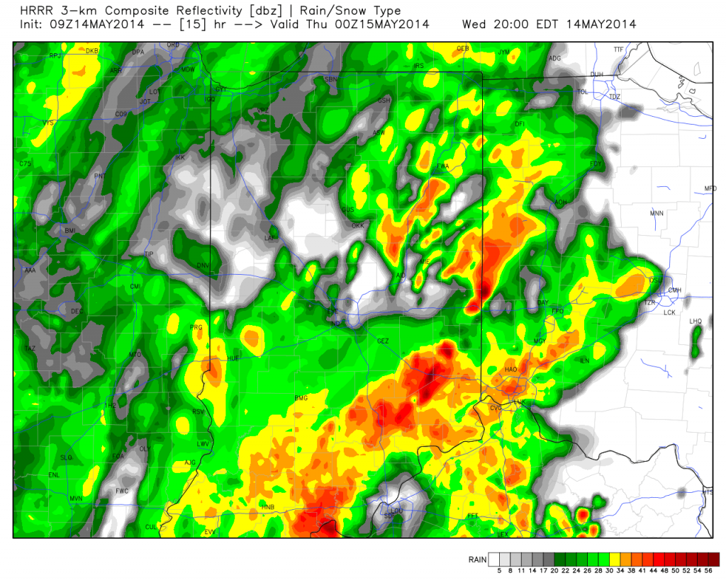
Note the forecast radar stays rather busy in the hours ahead!


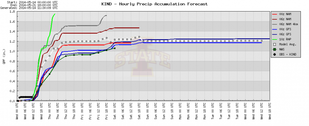
Area additional rainfall total will reach between 1-2″ between this morning and Friday afternoon.


The other big story is the chill. Temperatures are drastically cooler this morning than what we’ve gotten used to the past several days, and the step down process will continue. We still think most of Thursday is spent in the 40s.

Permanent link to this article: https://indywx.com/2014/05/14/promised-wet-chilly-pattern-here/
-
Filed under 7-Day Outlook, Forecast, Forecast Discussion, Forecast Models, NAM Model, Rain, Severe Weather, T-storms, Unseasonably Cool Weather, Weather Videos
-
May 13, 2014
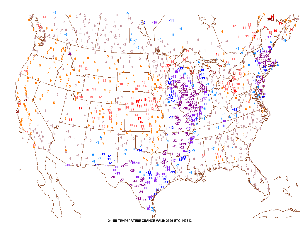
Note how dramatic of a temperature shift is occurring to our west- temperatures are down more than 30 degrees from this same time last night.

That cool air will filter into our region tonight and Wednesday. As a matter of fact, we still think Thursday has the potential to remain in the 40s for the better part of the day. The video below has more details on this and a look ahead to continued rainy times.
Permanent link to this article: https://indywx.com/2014/05/13/tuesday-evening-video-brief-the-cool-down-is-on/
-
Filed under 7-Day Outlook, Forecast, Forecast Discussion, Forecast Models, Heavy Rain, NAM Model, Rain, T-storms, Unseasonably Cool Weather, Unseasonably Warm
-
May 13, 2014
|
Tue.
|
Wed.
|
Thr.
|
Fri.
|
Sat.
|
Sun.
|
Mon.
|
|

|

|

|

|

|

|

|
|
67/ 80
|
50/ 67
|
45/ 52
|
40/ 56
|
41/ 57
|
39/ 62
|
43/ 65
|
|
Light
|
Moderate
|
Light
|
Light
|
Light
|
– – –
|
– – –
|
Stepping outside this morning you would think it was July or August. Unseasonably warm conditions are coupling with dew points in the middle to upper 60s to help create quite the muggy feel to the central Indiana air mass once again. This will help fuel showers and heavy rain producing thunderstorms today, especially during the PM. Perhaps the most widespread rain and thunderstorms will arrive Wednesday into early Thursday as a wave of low pressure moves up along a cold front that will be just east of our region by that time frame. We still forecast locally heavy rainfall amounts during the course of the next 48 hours, including widespread additional 1.25″-1.50″ totals. The other big story will be the dramatically cooler temperatures that filter in tomorrow. We’ve called Wednesday our transition day and that remains our idea now, as well. Temperatures will likely fall through the afternoon and evening hours. Speaking of cool, temperatures will remain in the 40s for the better part of your Thursday (hope you haven’t put those jackets and sweaters away just yet)! We’ll slowly begin to shake the showers and clouds over the weekend and have trended more optimistic for Sunday’s forecast into early next week.

Most widespread shower and thunderstorm activity will likely occur Wednesday into early Thursday.
Permanent link to this article: https://indywx.com/2014/05/13/showers-and-storms-then-much-cooler/
It’s a warm and muggy evening across central Indiana and showers and thunderstorms are in your forecast. More on this and the long advertised BIG cool down looming inside the…
You must be logged in to view this content. Click Here to become a member of IndyWX.com for full access. Already a member of IndyWx.com All-Access? Log-in here.
Permanent link to this article: https://indywx.com/2014/05/12/monday-evening-video-update/
|
Mon.
|
Tue.
|
Wed.
|
Thr.
|
Fri.
|
Sat.
|
Sun.
|
|

|

|

|

|

|

|

|
|
63/ 82
|
66/ 77
|
52/ 60
|
44/ 56
|
42/ 55
|
37/ 60
|
38/ 60
|
|
Light
|
Light
|
Moderate
|
Light
|
Light
|
Light
|
Light
|
The new work week will feature a very stormy and unsettled weather pattern. While everyone won’t get wet today, we do note the likely chance of afternoon thunderstorms bubbling up during the heating of the day. Like Sunday, any of these storms could feature torrential rain and could quickly pulse to severe levels. More widespread rain chances will arrive Tuesday into Wednesday in direct association with a cold front. The long advertised cooler pattern will arrive behind this front and set up an unseasonably cool time of things to close out the second half of the week and head on into the weekend. Rainfall totals this week will average an additional 1.25″ to 1.50″ with locally higher totals. As for temperatures, we’ll go from well above seasonal levels today (8-10 deg. above normal) to well below seasonal levels by mid week (20 deg. below normal).

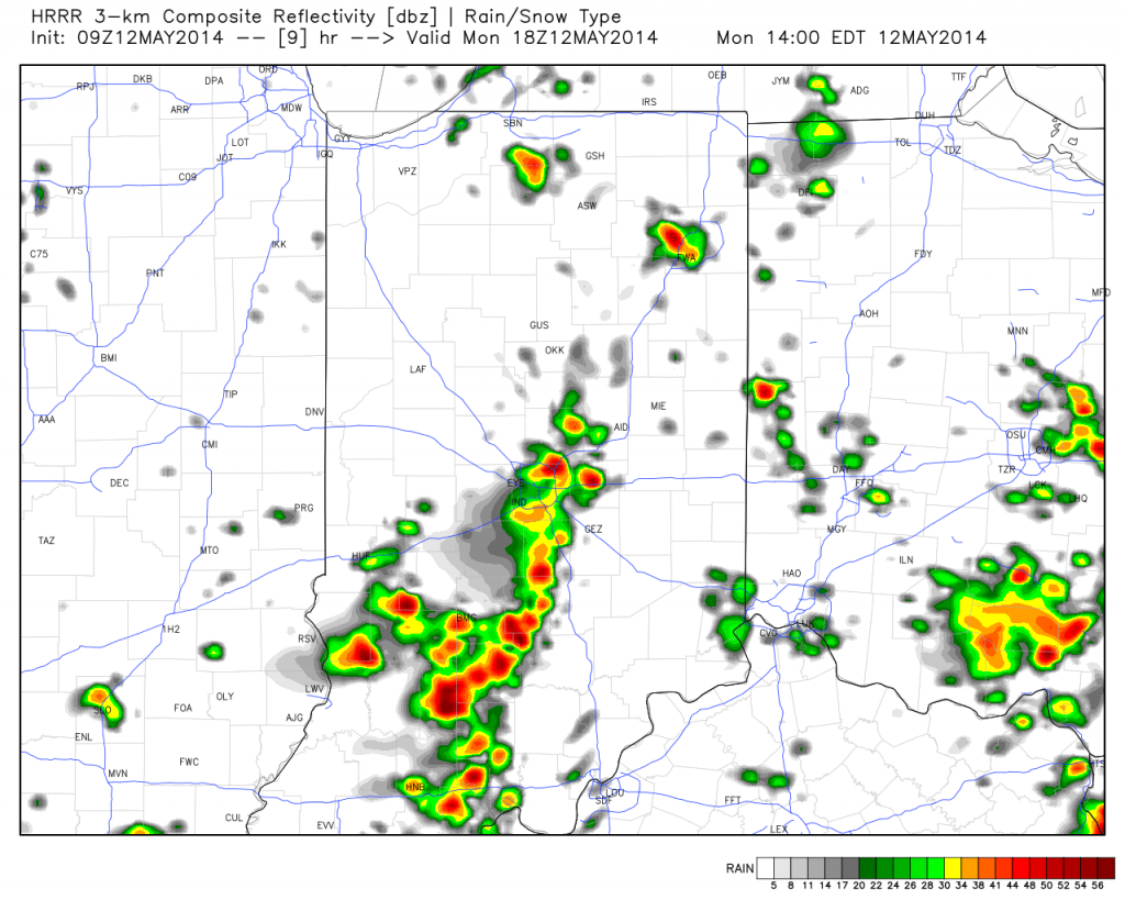
Forecast radar at 2:00p today, via the short-term high resolution HRRR forecast model.
Permanent link to this article: https://indywx.com/2014/05/12/unsettled-and-stormy-turning-much-cooler/
-
Filed under 7-Day Outlook, Forecast, Forecast Discussion, Forecast Models, GFS, Heavy Rain, Rain, Severe Weather, T-storms, Unseasonably Cool Weather, Unseasonably Warm, Weather Videos
-
May 8, 2014
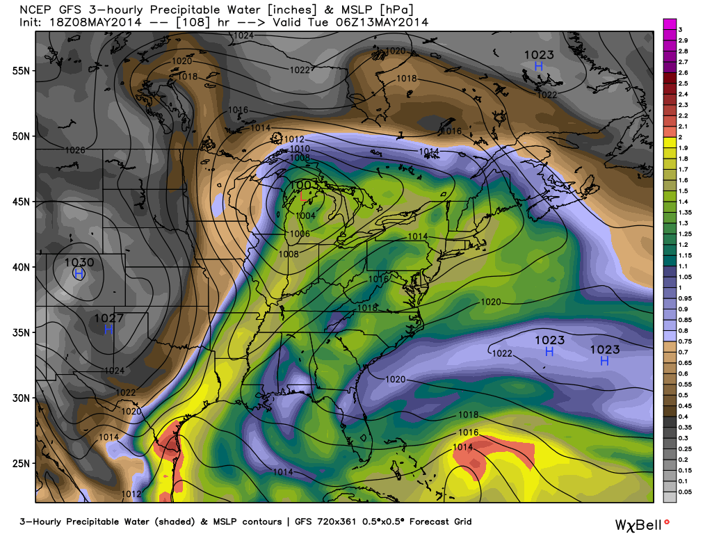
Posts this weekend will be a bit “off schedule” as I celebrate my brother’s graduation. That said, posts will hit the site over the weekend and we’ll also keep you updated on our Twitter feed- @indywx. A busy time of things lies ahead and a very active weather pattern will carry us into this time next week. Let’s get into some of the details!
1.) (2) rounds of showers and thunderstorms will be likely Friday. Weakening showers and embedded thunder will dissipate moving into central Indiana Friday morning. That said, depending on the amount of clearing that takes place behind the first wave of showers and storms will go a long way into determining the severity of round two Friday evening. The SPC (Storm Prediction Center) continues to highlight our area for a Slight Risk of severe weather (primary threats are large hail and damaging straight line winds) Friday evening. We also note the latest high resolution NAM simulated radar shows potential strong to severe thunderstorms moving in tomorrow evening.

2.) A second heavy rain and storm maker will arrive early next week. The Gulf of Mexico is open for business and suggests some locally heavy downpours are a good bet with both storms. This isn’t bad news as it’s been dry as of late. We’re now on day 9 without measurable precipitation and that will be changing in a big way over the upcoming 7 day period. Widespread 2″-2.5″ rains are a good bet over the upcoming week, including some locally heavier totals.

The detailed video discussion below covers more on the severe chances, heavy rain threat, and a much cooler pattern ahead!
Permanent link to this article: https://indywx.com/2014/05/08/smorgasbord-of-weather/
Thr. Fri. Sat. Sun. Mon. Tue. Wed. 63/ 84 64/ 70 59/ 73 57/ 81 66/ 80 49/ 67 43/ 59 – –…
You must be logged in to view this content. Click Here to become a member of IndyWX.com for full access. Already a member of IndyWx.com All-Access? Log-in here.
Permanent link to this article: https://indywx.com/2014/05/08/another-hot-day-today-busy-pattern-on-deck/

