Category: Forecast

Highlights:
- Increasing sunshine today
- Rain/ embedded thunder end as snow Tuesday
- Accumulating mid week snow
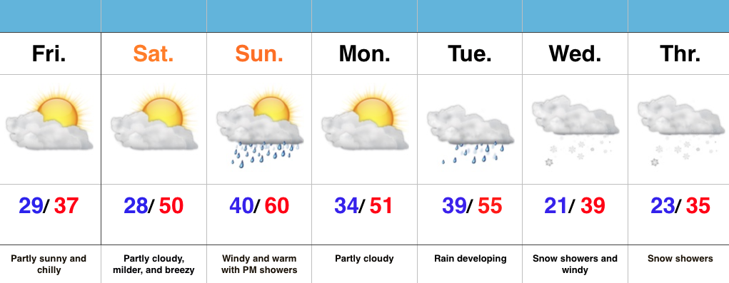
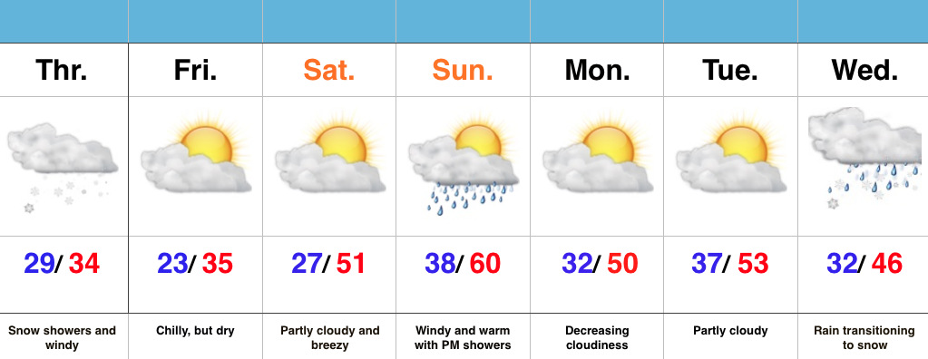
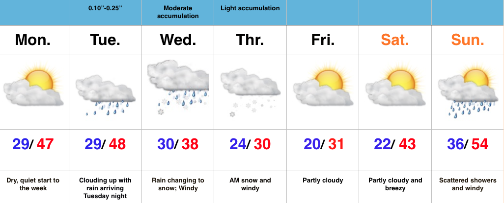
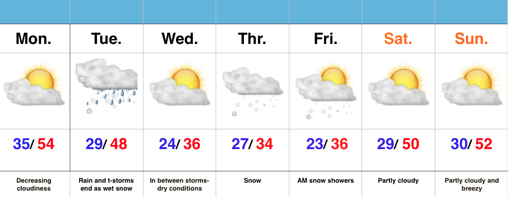
Busy Pattern This Week…After a windy and warm Sunday, a thin band of showers and embedded thunder moved through central IN last night. This was in association with a weak frontal boundary that will provide a dry start to the work week. Despite a cloudy start, sunshine should quickly develop as clouds decrease.
Quiet times won’t last long as our next storm system delivers showers and thunderstorms Tuesday. Colder air will quickly punch in here Tuesday afternoon and evening helping precipitation transition to wet snow before ending. We think the significant accumulations will remain north of central IN, but we’re keeping a close eye on things, nonetheless. Expect an evening update.
Busy times remain in the mid week period as a wave of low pressure spreads widespread snow across the area Thursday. Early indications would suggest this may be a plowable snow for some of the region.
As it stands now, moderating conditions and increasing sunshine are expected heading into next weekend. Longer term, a big ridge should develop across the area later next week. It’s a pattern supportive of anomalous warmth to the tune of 75-80 degrees….
Interested in our consulting options and personalized discussions to your business needs? E-mail bill@indywx.com for more information.
Permanent link to this article: https://indywx.com/busy-pattern-this-week/

Highlights:
- Dry, chilly close to the week
- Milder weekend
- Eyeing a mid week storm
Milder Weekend Ahead…Scattered flurries are flying across northeastern and eastern parts of the state this morning, but drier air is invading from the west and this should lead to increasing sunshine through the afternoon.
Though Saturday won’t be as warm as Sunday, it’s our pick of the weekend with lots of sunshine and mild temperatures. We’ll add wind and evening showers into the mix Sunday.
The next storm of significance is slated to arrive Tuesday. Though we’ll have to fine tune details as we move forward, for now we’ll go with developing rain Tuesday followed by a transition to snow showers Wednesday. Stay tuned.
Indications late next week are that we may have to deal with an active NW flow and snow-producing clippers.
Permanent link to this article: https://indywx.com/milder-weekend-ahead/

Highlights:
- Snow showers and windy
- Dry, chilly close to the week
- Turning milder this weekend
- Next storm lining up the middle of next week
Snowy Thursday; Milder Weekend…Windy and periodically snowy conditions will be with us today, especially this morning. Drier air will win out later tonight and set the stage for a chilly, but dry close to the work week.
Temperatures will get several positive boosts in the right direction just in time for the weekend. Despite a bit of a breeze Saturday, sunshine and lower 50s will be great! Things turn increasingly windy Sunday with afternoon/ evening showers possible.
Our next item of “interest” moves in the middle of next week. It’s far too early for specifics, but some data is eerily similar to our most recent event…
Permanent link to this article: https://indywx.com/heading-in-the-right-direction-for-the-weekend/
You must be logged in to view this content. Click Here to become a member of IndyWX.com for full access. Already a member of IndyWx.com All-Access? Log-in here.
Permanent link to this article: https://indywx.com/monday-evening-video-update-7/
Highlights:
- Nice open to the week
- Mid week winter storm for parts of the area
- Wind and heavy, wet snow
Mid Week Snow Storm For Parts Of The Area…Today is easy! Weak high pressure will supply dry skies and a quiet time of things, but trouble’s lurking for mid week.
Clouds will increase Tuesday and rain will move in Tuesday evening as a developing storm system lifts northeast out of Texas, into the TN Valley, and into the eastern Ohio Valley. Long term Hoosiers know that’s a classic track for a snow hit here across central IN and that will likely ring true for portions of the area Wednesday evening into Thursday. We forecast rain to transition to a heavy, wet snow from northeast to southwest Wednesday afternoon into the evening. There’s still fine tuning ahead, but as things stand now, this could be a significant event (6″+) for some central and northern IN neighborhoods. Stay tuned.
The other component of this storm will be a strong and gusty northeast wind that eventually shifts to the north and northwest Wednesday into Thursday. Cold conditions will be with us to wrap up the work week as the big dig begins for some.

Permanent link to this article: https://indywx.com/mid-week-snow-storm-for-parts-of-the-area/