Category: Forecast
 Highlights:
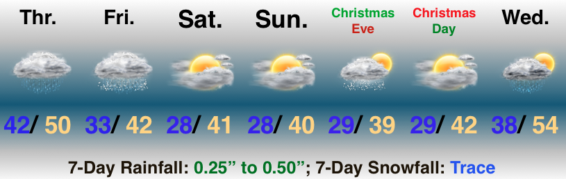
- Wet at times to close the week
- Rain ends as a bit of snow Friday
- Light snow potential on Christmas Eve
Milder Than Normal, But Damp At Times…A storm system will deliver periods of light rain to central Indiana today into the wee morning hours Friday. Steadiest rain will fall to our east, but we will notice greater overall coverage of rain this evening into the overnight period. As colder air wraps in here late tonight and Friday morning, precipitation will end as light snow (no accumulation is expected).
The weekend will feature quiet conditions and our attention will shift to the potential for a weak weather system to scoot through here on Christmas Eve. With just enough cold air in place, precipitation would likely fall as light snow. Again, this isn’t expected to be a big deal, but we’ll remain hopeful for a “touch” of snow as Santa gets set for his big night.
Dry conditions return on Christmas Day and temperatures will begin to moderate ahead of a big wet storm system that will arrive the middle of next week.
Permanent link to this article: https://indywx.com/damp-close-to-the-work-week-milder-than-normal-pattern-continues/
 Highlights:
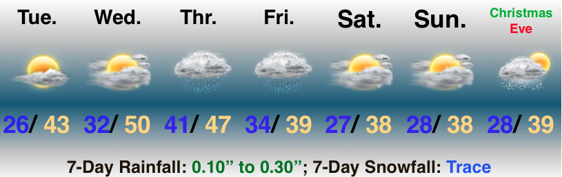
- Dry weather continues with a warming trend
- Light rain to close the week
- Weak system on Christmas Eve
Soak Up That Vitamin D…High pressure will remain in control of our weather and present quiet conditions with plentiful sunshine as we move through the next couple of days. Enjoy! Temperatures will also be on the uptick- flirting with, or exceeding, the 50° mark Wednesday.
Our next storm system will deal areas east of IN the worst of conditions from a wind, rain, and eventually snow standpoint, but we will get in on light rain and blustery conditions to close the work week. A couple of snowflakes may mix in with the precipitation before ending Friday.
Seasonably chilly and dry conditions return over the weekend before a weak weather system zips through here on Christmas Eve with a couple of light snow showers. Looking ahead, high pressure should lead to a return of sunshine with low-mid 40s on Christmas Day.
Permanent link to this article: https://indywx.com/rain-returns-to-close-the-week-christmas-looks-milder-than-average-and-dry/
 Highlights:
- Wet Saturday
- Nice stretch of weather on deck
- Next storm arrives late next week
Damp Today; Improvements On The Way…There’s no change to the thought that heaviest and steadiest rain will remain south of the I-70 “mountain chain,” but lighter rain and showers will push north, encompassing more of central Indiana as the day progresses. The trade off for today’s damp weather comes in the form of increasing sunshine Sunday through the middle of next week. Temperatures will run above normal, as well!
The next storm system will begin to impact the region Wednesday afternoon as clouds increase, eventually giving way to rain Thursday morning. As low pressure tracks northeast and strengthens, it’ll help pull enough cold air south to allow precipitation to transition to wet snow Friday.
Permanent link to this article: https://indywx.com/sunday-improvements-next-storm-arrives-late-next-week/
 Highlights:
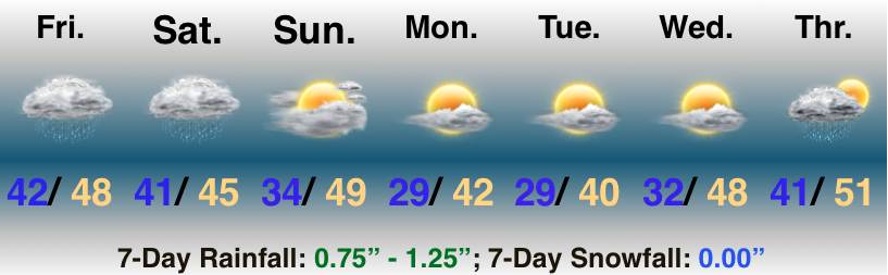
- Damp at times through Saturday
- Sunshine returns
- Looking ahead to Christmas
Rain Gear Needed…A storm system will lift north along the Ohio River between now and Saturday night before crossing the Appalachians and “jumping” to the mid Atlantic coast Sunday into Monday. This will result in periods of rain today and Saturday. Heaviest and most concentrated rainfall will remain along and south of the I-70 corridor- especially across southwest IN. For the majority of us, this won’t be a major rain event.
Improving weather will develop for the 2nd half of the weekend as we introduce at least a little sunshine into the forecast. That sunshine will set the tone for the new work week, including a nice stretch of weather (by late-December standards) Monday through Wednesday.
A cold front will blow through the state Thursday with a shower possible, followed by colder air to close the work week.
Looking ahead towards Christmas, we still anticipate this to be around the timeframe that we’re transitioning back to colder air. It’s far too early to get specific around rain or snow, but the transitional pattern does support the idea of more active times. Stay tuned…
Permanent link to this article: https://indywx.com/damp-open-to-the-weekend-improvements-on-the-way/
 Highlights:
- Unsettled at times to close the week
- Rainfall reaches peak intensity/ coverage overnight Friday
- Nice stretch of weather next week
Damp Few Days…A slow moving storm system will result in periods of showers today through Saturday, but there will also be plenty of dry time in the mix as well. We expect heaviest and most widespread rain to roll in here late Friday night into the predawn hours Saturday. Most can expect to pick up between 0.75″ and 1.25″ by noon Saturday. Improving weather will develop Saturday afternoon and at least a little sunshine should work in here to close the weekend.
The week before Christmas will be unseasonably pleasant which is music to the ears of many rushing to complete their shopping and getting on the road to visit family and friends. High pressure will supply a string of sunny days and temperatures will run milder than average, as well. In fact, highs by the middle of next week will likely exceed the 50° mark in spots across central Indiana!
Permanent link to this article: https://indywx.com/unsettled-at-times-pleasant-stretch-of-weather-next-week/
