Bitter Times Ahead; Weekend Storm…
 Highlights:
- Bitterly cold
- Weekend storm delivers a little bit of everything
- Cold reloads over the weekend
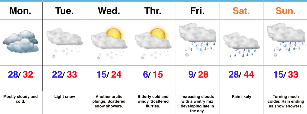
Cold That Hurts…Tuesday was a snowy day across central IN. Most snow reports checked in around 3″, but there were a few “lucky” folks who accumulated north of 4″. Not bad at all!
Two pieces of arctic air will invade mid week. The first piece is arriving on the scenes as we type this forecast Tuesday evening. It’ll send lows into the single digits to lower teens by Wednesday morning. Patchy freezing fog will also be noted in spots. Needless to say, don’t get too confident on area roadways. Despite the phenomenal work central IN road crews do (seriously, thank you), there will be icy spots tonight and Wednesday morning. Slow down! 🙂
A second surge of arctic air will arrive Wednesday afternoon and evening. Everyone gets in on the single digit party Wednesday night and Thursday morning. In fact, don’t be surprised by a few folks checking in with a below zero report here and there. Winds will be strong and gusty and lead to wind chill values of 10-20 below zero into Thursday morning. Heavy winter attire will be required.
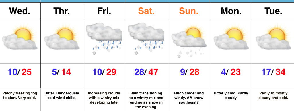
Our attention then shifts to a developing weekend storm that will deliver a wintry mix late Friday followed by a transition to rain as temperatures zoom (briefly) into the 40s Saturday. The milder surge won’t last long as arctic air oozes back into central parts of the state Saturday afternoon and evening. As this is happening, a second wave of moisture will ride up along the arctic front. We expect rain to mix with and change to a wintry mix of sleet and freezing rain before ending as snow Saturday night/ early Sunday morning. This may be another accumulating wintry event and we’ll keep a close eye on things.
Cold, dry weather will be with us as we kick off Christmas week. Speaking of Christmas week, the bitterly cold air will “relax,” but the pattern remains active. Despite the relaxation in the frigid times, conditions will remain cold enough for wintry potential leading up to, or around, Christmas…
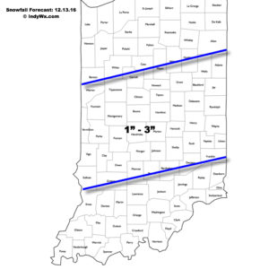
Upcoming 7-Day Precipitation Forecast:
- Snowfall: 1″ – 3″
- Rainfall: 0.25″ – 0.50″
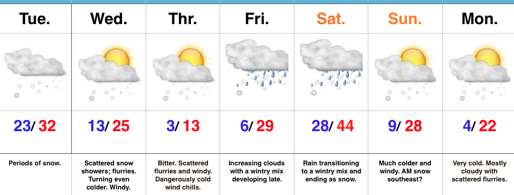
 Fresh arctic air will pour into the region tomorrow evening, along with a gusty NW wind. Tuesday’s snow should be rather wet in nature so we don’t anticipate blowing/ drifting issues to result as the arctic hounds roar into town. However, there will likely be periods of flurries and scattered snow showers as the bitterly cold air arrives in the Wednesday-Thursday time frame and this could lead to light additional coatings in spots. The big weather story through mid and late week will be the bitter air. “Air that hurts” is what we’re calling it and wind chill values will approach 20 degrees below zero Wednesday night/ Thursday morning.