Category: Forecast

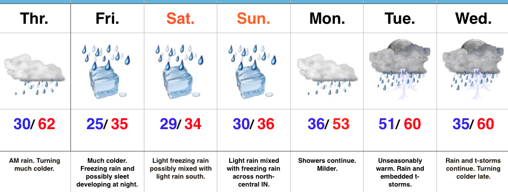
Saturday Morning Freezing Rain Update…

More widespread precipitation is spreading across central Indiana this morning.  Most of this precipitation is falling as freezing rain.

Radar at 7:19a.

Radar at 7:19a.

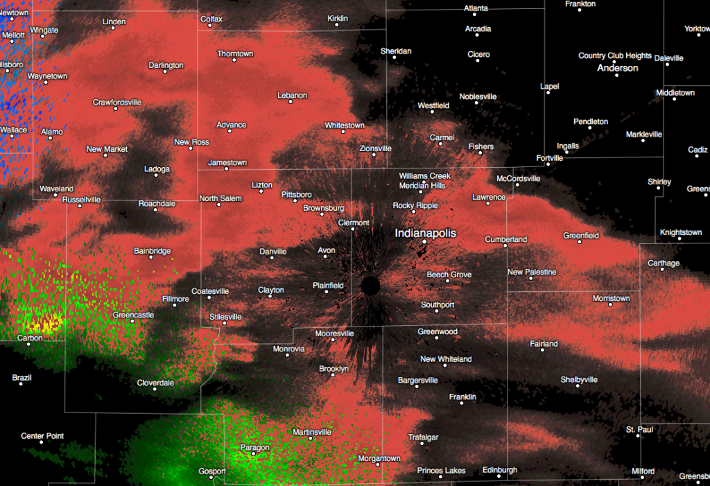
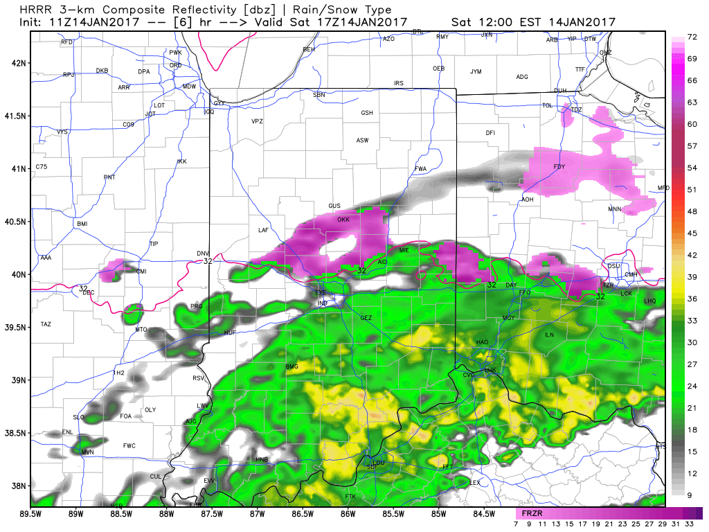
Modeled forecast radar continues to show moisture streaming across the region through around the lunchtime hour before diminishing.

9a forecast radar

9a forecast radar

12p forecast radar

12p forecast radar

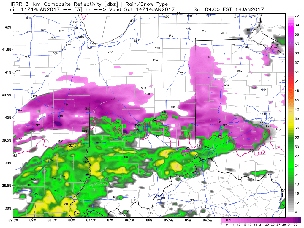
Temperatures will remain around 30-32 degrees along and north of the I-70 corridor as this rain falls so it’ll freeze on contact.  Allow extra time if you must travel and slow down.  Due to our phenomenal road crews and marginally cold temperatures, we don’t expect major travel issues this morning, but do use caution if traveling.  A light glaze of ice (around 0.10″) is possible on elevated surfaces, including tree limbs and power lines.

Temperatures will go above freezing this afternoon across most of central Indiana and precipitation will end.  Highs both today and Sunday should top out in the middle 30s across the region.

5p forecast radar

5p forecast radar

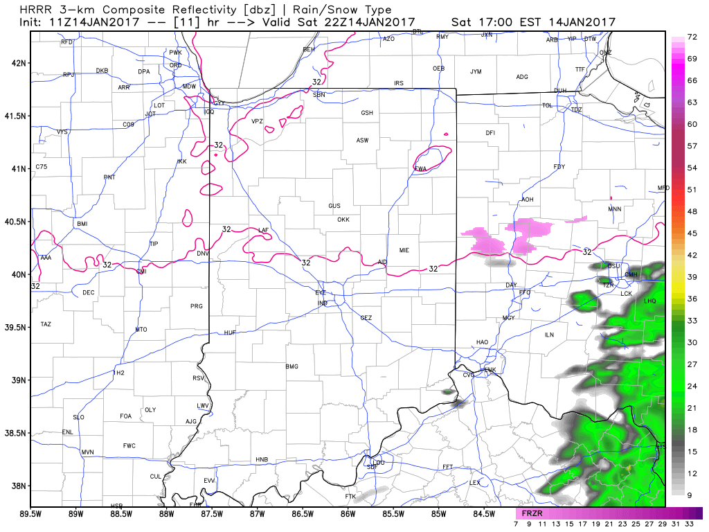
Lows tonight will settle back down into the middle to upper 20s, but dry conditions should remain for most of the night.

10p forecast radar

10p forecast radar

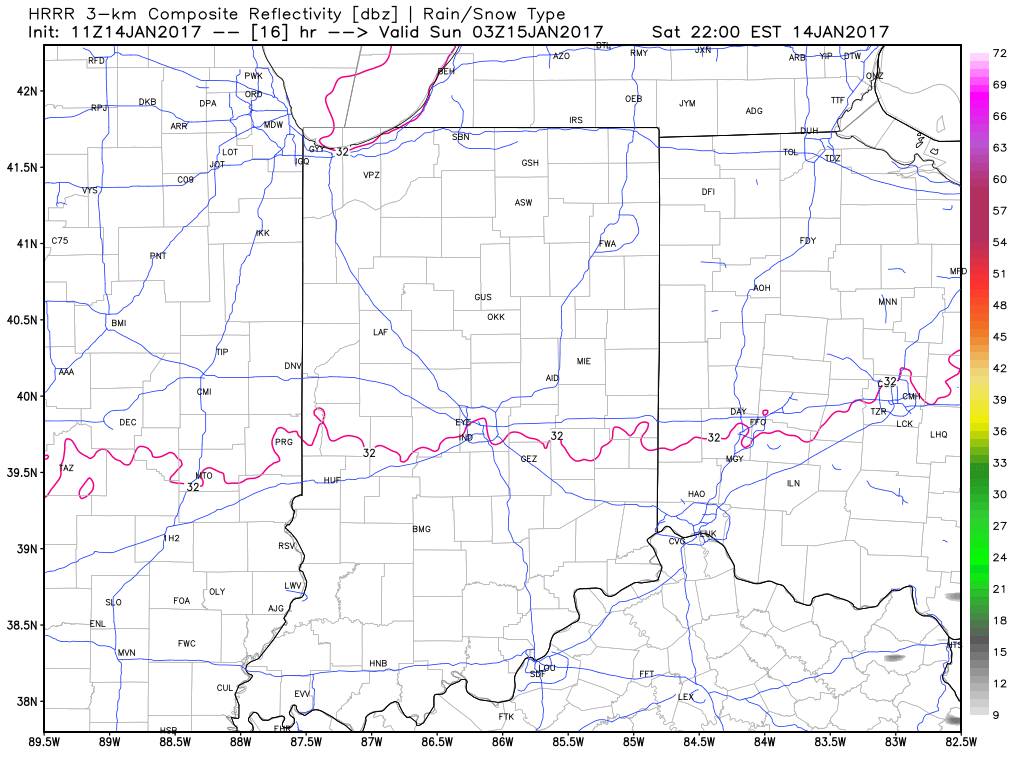
Our next round of precipitation looks slated for a Sunday morning arrival and, similar to this morning, this precipitation will likely fall as a mixture of light rain and light freezing rain.

Updated 7-day out later!  Have a great Saturday!

Permanent link to this article: https://indywx.com/saturday-morning-freezing-rain-update/

Surge Of More Widespread Precipitation Saturday Morning…

Light freezing rain and drizzle has been falling across central Indiana this evening, mainly from the city, itself, and points south. A light glaze of ice has been reported into the forecast office in Monrovia and Plainfield. 

For the next several hours, patchy light freezing rain and drizzle will continue, but nothing in a widespread, “uniform” fashion (great news for those night owls out and about).

However, we do note some of the higher resolution forecast models suggesting a waive of more widespread precipitation arriving into central Indiana Saturday morning. This most likely pushes in sometime between the hours of 7a-9a and encompasses the heart of the state, including Indianapolis. 

This “slug” of moisture will continue to fall across central Indiana through the morning hours before tapering off and diminishing around lunchtime. The afternoon and evening should be void of any widespread precipitation of significance. 

While this won’t be a crippling event by any stretch of the imagination, be careful for slick spots Saturday morning and allow road crews room for salting. In general 0.05″-0.10″ of glaze still seems like a good bet for most central Indiana neighborhoods by lunchtime Saturday. 

More in the morning! Have a great night!

Permanent link to this article: https://indywx.com/surge-of-more-widespread-precipitation-saturday-morning/

Weekend Ice And Heavy Rain Next Week…

Screen Shot 2017-01-12 at 7.08.19 AM

Highlights:

  • Turning colder
  • Freezing rain develops Friday night
  • Wet times continue

Active Times; Excessive Rainfall Risk Next Week…The overall weather pattern remains very active AND very wet.  By the time all is said and done, an additional 3″ of rain is possible for a widespread portion of the region by the middle of next week, with locally heavier amounts.  Lets time it out.

The focus in the shorter-term is for colder air to build in.  Temperatures today will fall (after a spring-like feel during the wee morning hours).  We’ll be in the 30s by mid to late afternoon and below freezing later this evening.  Arctic high pressure will continue to force cold, dry air south across central IN as we wrap up the work week.  At the same time, warm, moist air aloft will ride over the cold air trapped at the surface and trouble looms by Friday night.  We expect light freezing rain to develop after dark and continue into Saturday morning.  As disturbances move along the arctic boundary, additional precipitation (mostly light) will overspread central Indiana from time to time over the weekend.  We want to continue to reiterate that a 1-2 degree temperature difference will mean a tremendous difference between additional ice accumulation and plain ole cold rain.  Thinking is that the freeze line will shift north of the I-70 corridor Saturday afternoon before settling south towards I-70 again Saturday night and Sunday morning.  We still have time to fine tune things, but as of now it seems likely that anywhere from 0.10″ to 0.20″ of glaze (freezing rain) will be possible across most central IN communities Friday night into Saturday.

We’ll get rid of the freezing rain early next week and bust back into a warm southwesterly air flow.  Models are struggling with the precise details of how things evolve in the early-mid week period, but confidence remains very high on continued wet times.  In fact, the GFS pulls a slug of 1.5″ precipitable water values (PWATs) north into the state the middle of next week and suggest the heavy rain threat remains Tuesday and Wednesday.  By the middle of next week, we have to start becoming concerned for flood potential across the region.

Hang in there, we’ll see the sunshine return…some day.

Upcoming 7-Day Precipitation Forecast:

  • Snowfall: 0.00″
  • Rainfall:  2.50″ – 3.00″ 

Permanent link to this article: https://indywx.com/weekend-ice-and-heavy-rain-next-week/

Prolonged Stretch Of Gloomy Weather…

screen-shot-2017-01-10-at-7-25-16-amHighlights:

  • Active stretch of weather begins
  • Moderating trend into midweek
  • Ice concerns Friday-Saturday

Sunglasses NOT Required…We’re entering the beginning of an active stretch of weather, with an extended period of overcast skies and gloomy conditions.  Let’s dive in and take the challenges one-by-one:

Showers develop this afternoon as a cold front moves into the state.  Ahead of the front, strong southwest winds will gust upwards of 45 MPH+.  A “big hair warning” is in effect.  🙂

A brief shot of colder air will arrive late tonight into Wednesday, but just as soon as it arrives, it’ll leave and temperatures will approach 60 Wednesday night as showers return.

Thursday will be a wet day with periods of rain and slowly falling temperatures during the afternoon/ evening.

Friday is much colder as the arctic front will be to our south, but most of the day looks dry.  Moisture will lift north Friday afternoon and evening and with cold air in place, the precipitation should take the form of a mixture of freezing rain and sleet.  Periods of freezing rain likely continue Saturday.  It’s far too early to discuss amounts and we also want to reiterate the difference of 1-2 degrees will mean a world of difference between areas dealing with ice versus a cold rain.  The “battle zone” looks to take place across central IN.  If you have travel plans Friday night and Saturday, please keep abreast of later forecasts and updates.

Regardless of whether or not we’re dealing with icy conditions across central IN during the first half of the weekend, temperatures will warm during the second half of the weekend and change any frozen/ freezing precipitation over to plain ole cold rain Sunday into Monday.

Upcoming 7-Day Precipitation Forecast:

  • Snowfall: 0.00″
  • Rainfall: 1.50″ – 2.00″

Permanent link to this article: https://indywx.com/prolonged-stretch-of-gloomy-weather/

Busy Weather Week; Ice Storm Potential Friday Into The Weekend…

screen-shot-2017-01-09-at-7-26-23-amHighlights:

  • Late night light freezing rain develops
  • Milder and wet through mid week
  • Ice storm potential on the rise late week

Feeling Downright Balmy Out…Temperatures this morning (writing this at 7a) are running close to 20 degrees above where we were this exact time Sunday.  20 degrees has never felt so warm!  🙂  This moderating trend will continue into mid week, including temperatures that approach 60 Thursday.  That said, we have a mini “speed bump” to go over tonight and that’s the opportunity for light freezing rain late tonight into the wee morning hours Tuesday.  Temperatures should go above freezing just before the morning rush Tuesday, but plan to leave additional time as slick spots may remain.  Once we clear the “speed bump,” it’s off to the races in the temperature department through mid week: around 50 Tuesday afternoon and around 60 by Thursday (that’s a late night high Wednesday in the upper 50s).  Periods of showers will come with the milder air, centered on Tuesday and late Wednesday into Thursday.

Unfortunately, the milder times don’t last long and we still forecast “trouble” late in the week.  The set-up remains unchanged as a big, sprawling arctic high pushes into Wisconsin Friday.  This will help “shove” the arctic front through Indiana before stalling along the Ohio River Friday into Saturday.  As this is happening, ripples of energy will help ignite periods of precipitation Friday into the weekend.  With cold air locked in at the surface, we expect the potential of a rather prolonged period of freezing rain developing late Friday and continuing into the weekend.  We still have time for things to change, but from this distance, the predominant precipitation type, unfortunately, appears to be freezing rain.  Stay tuned as this could be a high impact event.

Upcoming 7-Day Precipitation Forecast:

  • Snowfall:  0.00″
  • Rainfall:  1.50″ – 2.25″

Permanent link to this article: https://indywx.com/busy-weather-week-ice-storm-potential-friday-into-the-weekend/