
You must be logged in to view this content. Click Here to become a member of IndyWX.com for full access. Already a member of IndyWx.com All-Access? Log-in here.
Category: Forecast
Permanent link to this article: https://indywx.com/video-short-term-update-on-our-high-wind-event-fresh-december-ideas/
Sep 27
VIDEO: From Record Heat To A Predominantly Cooler Pattern Ahead…
You must be logged in to view this content. Click Here to become a member of IndyWX.com for full access. Already a member of IndyWx.com All-Access? Log-in here.
Permanent link to this article: https://indywx.com/video-from-record-heat-to-a-predominantly-cooler-pattern-ahead/
Aug 28
Gorgeous Midweek Weather; All Eyes On Dorian As We Move Through Labor Day Weekend…
You must be logged in to view this content. Click Here to become a member of IndyWX.com for full access. Already a member of IndyWx.com All-Access? Log-in here.
Permanent link to this article: https://indywx.com/gorgeous-midweek-weather-all-eyes-on-dorian-as-we-move-through-labor-day-weekend/
Aug 07
Severe Potential East Thursday; Great Weekend On Deck, And Looking Ahead To Next Week…
Needed moisture missed much of immediate central Indiana Tuesday. Areas south of the city picked up some locally heavy downpours, but the early morning diminishing convection to our northwest helped stabilize things just enough to prevent storms from redeveloping locally.
There will be another opportunity for getting some needed rain Thursday, but we caution coverage, yet again, will likely be of the “hit and miss” variety. Given some of the ingredients, a couple of severe cells will be possible ahead of the frontal boundary Thursday afternoon. Best chances of being impacted by a storm Thursday will be across east-central Indiana as a line of storms across Ohio “tails back” into Indiana. Accordingly, the Storm Prediction Center (SPC) does include this part of the state in a Slight Risk of severe weather Thursday.
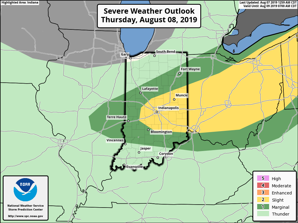
Primary concerns for any stronger thunderstorm that develops will be large hail and straight line winds.
As we look ahead to the weekend, sprawling high pressure is still expected to move overhead and produce plentiful sunshine, low humidity (you’ll notice a big drop in moisture levels Thursday afternoon to Friday morning), and very pleasant temperatures.
Our next chance of rain and storms will arrive Monday into Tuesday.
More a bit later with the issuance of our Wednesday evening video update! Enjoy your Wednesday!
Permanent link to this article: https://indywx.com/severe-potential-east-thursday-great-weekend-on-deck-and-looking-ahead-to-next-week/
Jun 19
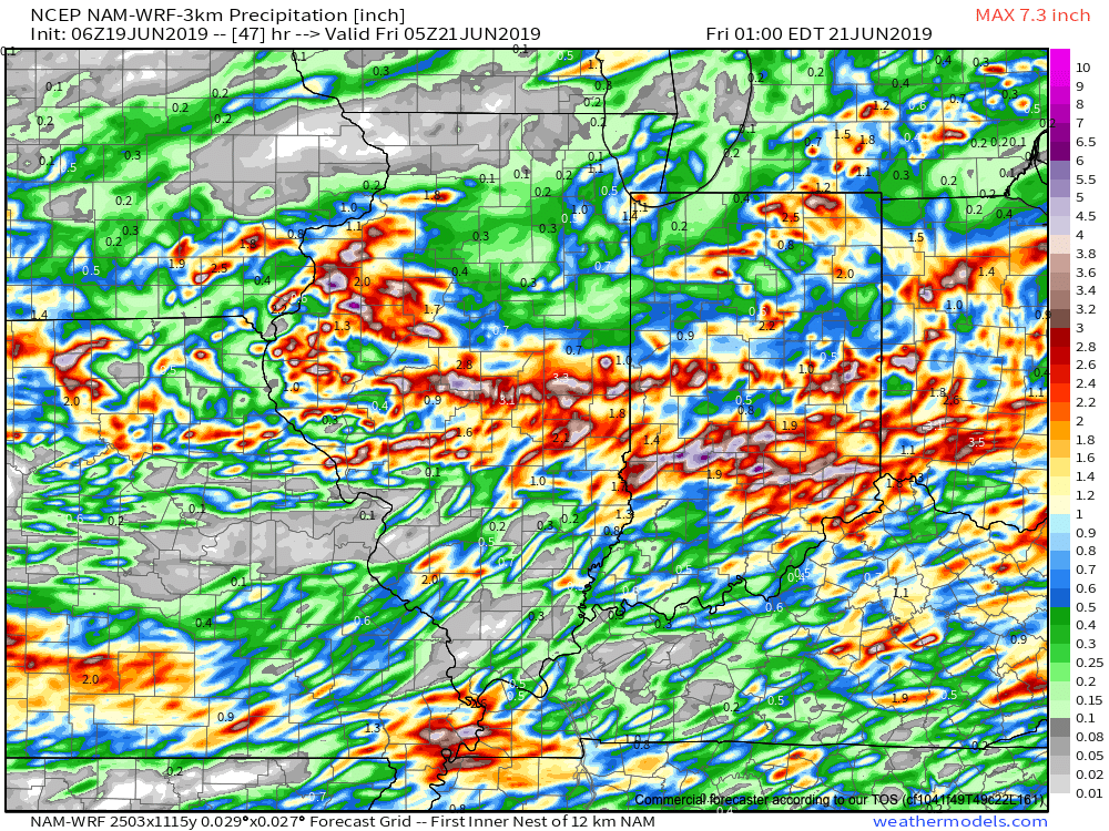
Concerned For Significant Flooding Tonight Into Thursday…
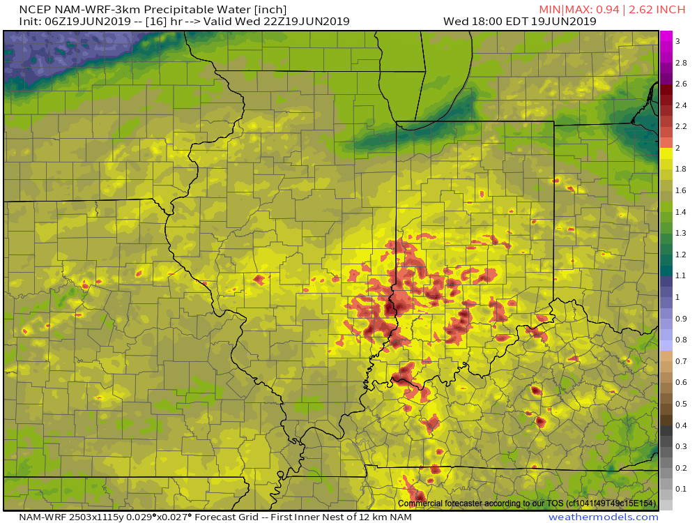
The day is opening dry across central Indiana (and sunny for some), but another heavy rain event looms by the end of the day. The culprit? A stalled front remains draped across central Indiana and a surface wave will move along this boundary this afternoon into tonight. A “juicy” airmass will remain intact across the region with precipitable water values topping out at 2.5″ across the southern half of the state. This will promote any shower or thunderstorm that develops to drop very heavy rainfall in a short period of time (1″ to 2″ per hour at times).
As the surface wave interacts with the tropical air mass in place, widespread showers and thunderstorms will blossom across the region through the afternoon into tonight. Rain will continue into Thursday afternoon.

We’re still also concerned for severe weather this afternoon and evening, including a couple of tornadoes across the southern half of the state.
By the time the rain comes to an end Thursday evening, widespread 2″ to 4″ can be expected across the heart of the state, including Indianapolis, itself.
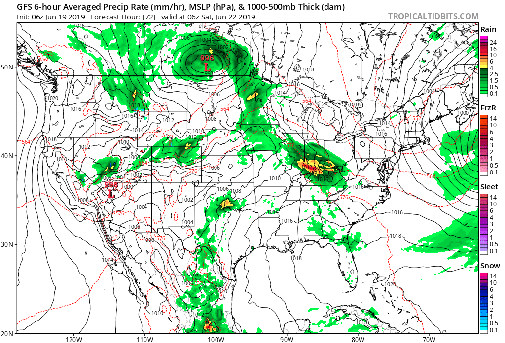
If that’s not enough, heavy rain and thunderstorms will return late Friday and continue in an “off and on” fashion straight through the weekend.
Unfortunately, some central Indiana rain gauges can expect to pick up an additional 5″+ of rain between this afternoon and next Tuesday…
Permanent link to this article: https://indywx.com/concerned-for-significant-flooding-tonight-into-thursday/