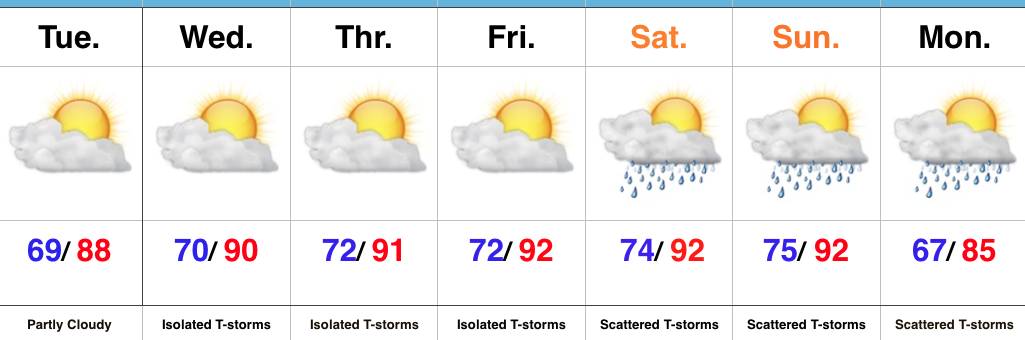
Category: Forecast
Highlights:
- Increasingly hot and humid
- Isolated storm coverage becomes more widespread
- Relief next week
Air You Can Wear…The big weather story will be the increasingly hot and humid feel as we progress through the week and on into the weekend. The combination of dew points in the 70s and wet soils across the state should “beat back” the heat from getting to where it otherwise could (mid-upper 90s), but it’ll feel oppressive, nonetheless. Plan to hydrate and wear cool, lightweight clothing if you plan to be outdoors for any length of time.
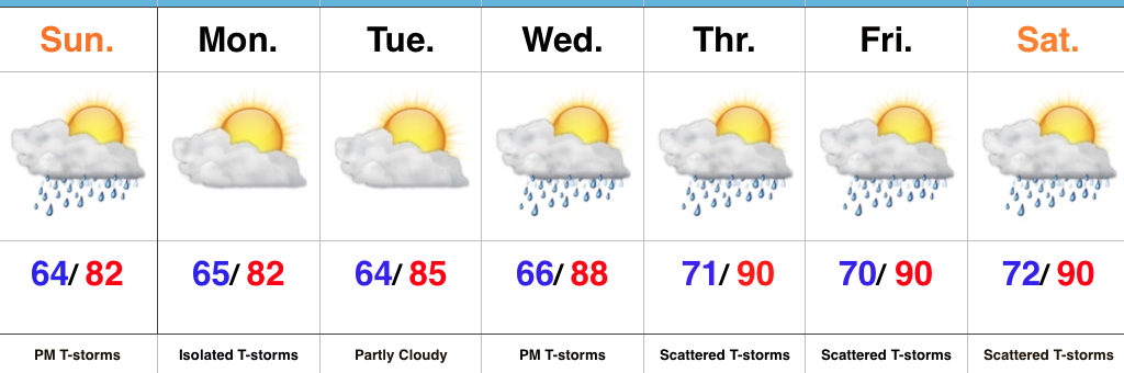
While we can’t completely rule out a renegade storm through Friday, most neighborhoods will remain free of any rain through the remainder of the work week. Better coverage of showers and thunderstorms will increase over the weekend into early next week as the transition from hot, humid weather begins to give way to a more pleasant feel.
Upcoming 7-Day Precipitation Forecast:
- Snowfall: 0.00″
- Rainfall: 0.50″ – 1.00″
Permanent link to this article: https://indywx.com/increasingly-hot-and-humid/
Highlights:
- T-storms arrive this afternoon
- Heating up this week
- Stormy periods late-week
Pleasant Start; Stormy Finish…After we got rid of the low level clouds and fog Saturday, it turned out to be a gorgeous day! The balance of our Sunday will also be very pleasant, but a frontal boundary will push through the state this evening and will be sufficient enough to kick up a line of showers and thunderstorms that will impact central IN this afternoon and evening. One or two of the storms could reach severe levels (large hail and damaging wind).
As we look forward, the big weather story this week will be the increasingly hot and muggy feel by late-week. Factor in that highs will approach 90° the second half of the week, along with dew points exceeding 70° and the stage will be set for a truly “oppressive” feel. Prepare to sweat.
Along with the increasingly heat and humidity, we’ll also note an increase in overall coverage of showers and thunderstorms through the late-week stretch. Individual disturbances will create periods of more widespread storms and with such a moisture rich air mass in place, expect periods of locally heavy rainfall.
Upcoming 7-Day Precipitation Forecast:
- Snowfall: 0.00″
- Rainfall: 1.50″ – 2.50″
Permanent link to this article: https://indywx.com/afternoon-and-evening-rumbles/
Highlights:
- Storms increase in coverage and intensity this afternoon
- More refreshing air arrives for the weekend
- Quiet start to next week
Stormy Afternoon On Deck…A frontal boundary will slip into the state today and slowly push south over the next 24 hours, eventually making it out of the state Friday. The combination of this trigger (front) along with a genuinely “soupy” air mass (precipitable water values will be north of 2″ and dew points will remain in the low-mid 70s) will result in increasing storm coverage this afternoon into the evening hours. Some of the storms may become severe and it also won’t take much for flash flooding to develop where storms train. In some cases, these storms will dump rainfall rates of 2″-3″/ hour. From a severe stand point, we’re most concerned for the potential of damaging straight line winds.
Thankfully, we’ll clear things out in time for the upcoming weekend. With the exception of a few morning thunderstorms downstate Friday, the trend will be a drier one and that will continue into Saturday. Along with the drier air, we’ll also note slightly cooler temperatures. It’ll feel much more refreshing than the past couple days.
A weak reinforcing cold front will sweep through the state Sunday evening and this boundary could kick-up a scattered thunderstorm or two Sunday afternoon-evening before we return to dry times Monday and Tuesday. Moisture (and heat) will return by the middle of next week.
Upcoming 7-Day Precipitation Forecast:
- Snowfall: 0.00″
- Rainfall: 1″-2″ (locally heavier totals)
Permanent link to this article: https://indywx.com/another-stormy-day-but-relief-is-coming/
Highlights:
- Tuesday and Thursday appear to be the stormiest days
- Drier trend to close the week; open the weekend
- Humid air gives way to a more refreshing feel
Stormy Periods…Storms are building across west-central Indiana this morning and these will settle into the city, itself, as the rush hour nears. This is only the beginning of multiple rounds of thunderstorms that will ride in a northwest to southeast fashion across central Indiana today. With dew points in the lower and middle 70s and precipitable water values exceeding 2″, additional flash flooding will result today for some communities where storms “train” over the same areas. A couple of strong-to-severe storms are also possible this afternoon with large hail and damaging straight line winds the biggest concern.
While we can’t rule out a passing storm Wednesday, overall storm coverage should be significantly reduced tomorrow as we get in on bit of a breather before another active time of things Thursday.
A surface front will settle south Friday. Best thunderstorm chances should occur during the front half of the day before a drier regime builds in from the north Friday evening and into Saturday. Temperatures will cool slightly, but we’ll really be able to notice a dramatic reduction in the humidity.
Sunday should be mostly dry, but we note a weak secondary boundary that will pass late in the day. This may be just enough to kick up a shower or thunderstorm Sunday afternoon or evening.
Upcoming 7-Day Precipitation Forecast:
- Snowfall: 0.00″
- Rainfall: 2″-3″ (locally heavier amounts)
Permanent link to this article: https://indywx.com/another-stormy-day/
Highlights:
- Beautiful Sunday
- Multiple rounds of heavy rain and storms through the work week
- Cooler next weekend
Gearing Up For Busy Times…We’ll wrap the weekend up on a pleasant note with plentiful sunshine and low humidity. Enjoy it as active times loom…
We’ll begin to notice an increase in humidity as early as tonight and there’s a chance some of our far western counties could get in on a shower or thunderstorm this evening into the nighttime. Better coverage of showers and thunderstorms will come in waves beginning Monday and continuing through the majority of the work week. Individual disturbances moving southeast will have ample energy and moisture to work with and it won’t take much for storms to become severe in this kind of set-up. Dew points will reach “oppressive” levels Monday into Tuesday (70°+) and precipitable water values will exceed 2″ at times. Accordingly, where storms “train” there’s the potential of 3″-6″ of rain by week’s end.
While we can’t shut off rain and storm chances, we can introduce cooler and drier air working in here by the weekend. Despite the drier, more refreshing feel, an active northwest flow will remain and a secondary cold front may sweep through the state Saturday, sparking additional showers and storms.
Upcoming 7-Day Precipitation Forecast:
- Snowfall: 0.00″
- Rainfall: 2″-3″ (locally heavier amounts)
Permanent link to this article: https://indywx.com/heavy-rain-strong-storms-this-week/