Category: Forecast
 Highlights:
- Needed dry time
- Frosty mornings
- Heavy rain and storms return
Drier, But Unseasonably Cool…Much-needed dry time has arrived. High pressure will dominate our weather pattern this afternoon through Monday, supplying dry skies. Despite the return of the sunshine, temperatures will continue to run much cooler than average. In fact, with drier conditions in place, overnight lows will tumble into the frosty range Sunday and Monday mornings. Cover up that tender vegetation.
Our next weather maker will arrive on the scene by the middle of next week as a frontal boundary stalls out over the region. Unfortunately, this is a rather ominous signal for heavy rains to return. We forecast periods of showers and thunderstorms Tuesday through Thursday before wrapping up the work week with scattered showers. We’ll keep a close eye on the data over the next few days as additional heavy rains are the last thing we need.
Upcoming 7-Day Precipitation Forecast:
- Snowfall: 0.00″
- Rainfall: 1.50″ – 2.00″
Permanent link to this article: https://indywx.com/2017/05/06/frosty-mornings-heavy-rain-returns-next-week/
 Highlights:
- Limited sunshine
- Another big rain event awaits
- Prolonged period of chilly weather
Jackets And Rain Gear Needed…Without question, Tuesday appears to be the “pick of the week” across central Indiana as we get into some briefly drier air. Enjoy it, as a new storm system will deliver heavy, wind-driven rain and unseasonably chilly air as we progress through mid and late week.
Clouds will lower and thicken Wednesday morning and give way to an expanding shield of rain as morning wears into afternoon and evening. As the surface low tracks closer to the region, an increasingly strong and gusty easterly wind will develop and combine with the chilly rain to lead to a truly “raw” period of weather to close the work week. It’ll feel more like early-March than early-May around these parts. Unfortunately, it still appears as if this next storm will deliver hefty rainfall totals on our already water-logged landscape. Data paints a widespread swath of 2″-3″ totals with locally heavier amounts. Flooding, once again, appears likely and if you live near a body of water, it’ll be important to keep a close eye on water levels Thursday into the weekend.
Widespread rain Friday should slowly give way to improving weather conditions over the weekend: scattered showers Saturday and dry, cool weather Sunday. Speaking of cool, temperatures will continue to run well below average, and lows Saturday through Monday mornings’ may result in patchy frost in outlying areas…
Upcoming 7-Day Precipitation Forecast:
- Snowfall: 0.00″
- Rainfall: 2.50″ – 3.50″
Permanent link to this article: https://indywx.com/2017/05/01/another-big-rain-maker-unseasonably-chilly/
 Highlights:
- AM showers then cooler and windy
- Stormy weekend ahead
- Cooler next week
Busy Times In The Weather Office…A cold front will sweep through the state this morning with lingering showers and an abrupt wind shift. Gusty westerly winds and cooler air (we’ve already seen our high for the day) will be with us this afternoon, along with a variably cloudy sky.
Unfortunately, we don’t have many changes to the ongoing idea of hefty weekend rains. A warm front will begin to slowly lift north Friday into Saturday and this will be the focal point for heavy rain and thunderstorms. Overall coverage and intensity of rain and thunderstorms will increase as we rumble through the second half of Friday. A couple of storms could be strong to severe- especially across southern Indiana Friday afternoon and night.
The aforementioned warm front will lift north and be located across the southern Great Lakes region Sunday. This will put our neck of the woods squarely into the warm and humid air mass Sunday. Though storm coverage will likely be more scattered in nature when compared to Saturday, heavy thunderstorms will develop, especially during the afternoon and evening hours. With a deep-rooted tropical connection along with saturated soils in place from early weekend rains, flood and flash flood potential will be high as we go into early portions of next week.
As we open up the work week, we’ll shift gears from a moisture-rich southerly flow to one that’s out of the northwest and much cooler. Showers will continue through Monday. Our next storm system will then set it’s eyes on the region by the middle of next week.
Upcoming 7-Day Precipitation Forecast:
- Snowfall: 0.00″
- Rainfall: 2.50″ – 3.50″
Permanent link to this article: https://indywx.com/2017/04/27/busy-weather-pattern/
 Highlights:
- Unsettled times ahead
- Weekend heavy rain
- Much cooler and windy early next week
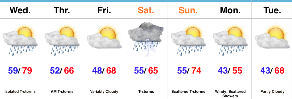
Enjoy The Dry Time While You Can…While most of Wednesday will remain rain-free, we do note the potential of a diminishing line of thunderstorms that could impact portions of far northwest sections of the state Wednesday morning. As mentioned, these should diminish relatively quickly and give way to a mostly dry day. A cold front will approach the state Wednesday night into Thursday morning and result in more widespread showers and thunderstorms during that time. Briefly drier air will arrive Thursday evening into Friday and we should wrap up the work week mainly dry.
We’ll take whatever dry weather we can get as the weekend still looks wet and stormy. We discussed the weekend setup this morning and thoughts haven’t changed a bit. Today’s model data continues to suggest we’re looking at periods of heavy rainfall with widespread weekend totals of 2″-3″ (locally heavier amounts possible). Of the two days, Saturday appears to offer up the most widespread rains, but we caution that the scattered showers and thunderstorms that develop Sunday will have the potential of depositing hefty totals in relative short order. Due to the projected steering currents, we’re also concerned for the possibility of “training” of heavy rain and that would quickly create a flash flood concern in localized areas. Stay tuned. Another item of interest is the possibility of “bust potential” with regard to the temperature forecast Saturday. Latest modeling wants to keep the warm front just south of the immediate region for most of the day now and, as such, we’ve trended cooler with Saturday’s temperatures before that warm southwesterly air flow wins out Sunday.
The warmth won’t last long as we quickly transition to a cooler west and northwest regime to open the work week. Along with the much cooler air, scattered showers and strong and gusty winds will be with us. We’ll finally begin to calm down with a very pleasant Tuesday expected.
Upcoming 7-Day Precipitation Forecast:
- Snowfall: 0.00″
- Rainfall: 3.00″ – 4.00″
Permanent link to this article: https://indywx.com/2017/04/25/dry-time-is-limited/
 Highlights:
- Sun-filled open to the week
- Midweek storms
- Warm, humid, and stormy weekend
Dry Open To The Week Transitions To A Stormy Finish…High pressure and a refreshing northeast flow will continue to dominate our weather as we open up the work week. Dry skies will prevail and the crisp mornings will warm quickly into the 70s both today and Tuesday.
A cold front will approach late Wednesday and help showers and thunderstorms increase Wednesday night into Thursday morning.
We’ll be in between storm systems Friday and a pleasant close to the work week will result. That said, a warm front will lift north and move through the region Saturday and this will help shower and thunderstorm coverage increase significantly Saturday morning. A much warmer and more humid feel will overspread the area once the front blows through and an unstable airmass will continue to promote shower and thunderstorm chances Sunday. Locally heavy rains are a good bet this weekend.
Upcoming 7-Day Precipitation Forecast:
- Snowfall: 0.00″
- Rainfall: 2.50″ – 3.00″
Permanent link to this article: https://indywx.com/2017/04/24/nice-open-to-the-week-before-a-stormy-finish/
 Highlights:
- Showers south today
- Unseasonably cool and blustery
- Increasing sunshine Sunday
- Midweek storms
Jackets Required Today, But Improving Weather Tomorrow…A stiff northeast wind is “eating away” at the northern extent of rain today. Steadiest rains will fall across the southern third of the state, but a couple of showers may make it as far north as Indianapolis later this afternoon. The bigger story will easily be the brisk northeast flow and unseasonably chilly air. In fact, we’re waking up to wind chills in the 30s this morning. Jackets are required today.
Drier air arrives on the scene tonight and clouds will decrease overnight, paving way for a beautiful Sunday. Expect plentiful sunshine and moderating temperatures. Dry and pleasant weather continues into midweek before an approaching cold front delivers our next chance of thunderstorms Wednesday evening.
Another fast-moving weather maker will deliver thunderstorm chances to close the work week.
Upcoming 7-Day Precipitation Forecast:
- Snowfall: 0.00″
- Rainfall: 1.00″ – 1.50″
Permanent link to this article: https://indywx.com/2017/04/22/chilly-saturday-gives-way-to-improving-weather-sunday/
We’ll wrap the work week up with filtered morning sunshine, but clouds will quickly lower and thicken as the day progresses and give way to showers later tonight.
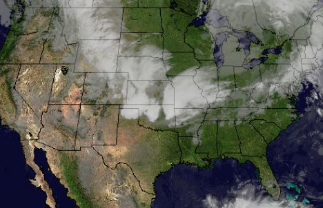
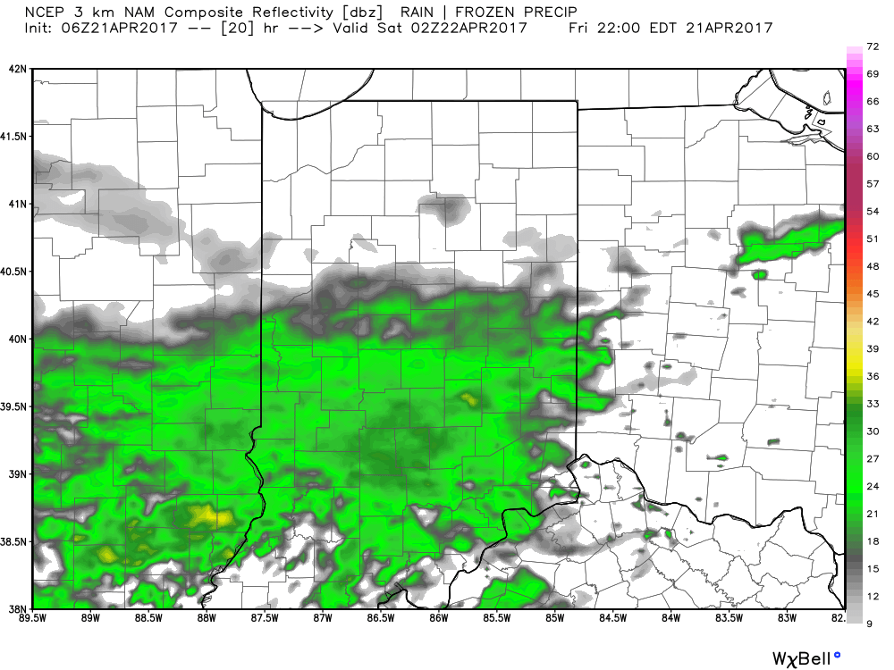 It’ll be a much cooler day today (temperatures are running close to 20° cooler than this time Thursday morning) with highs only topping out around 60 for the city, itself, and only into the mid to upper 50s across north-central Indiana.
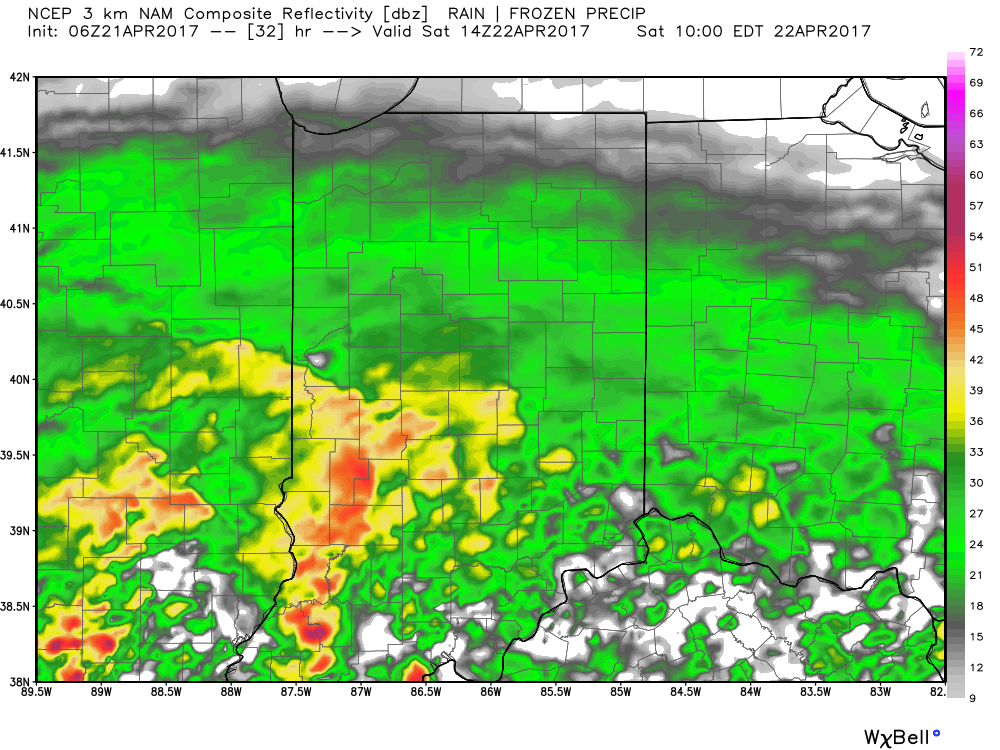
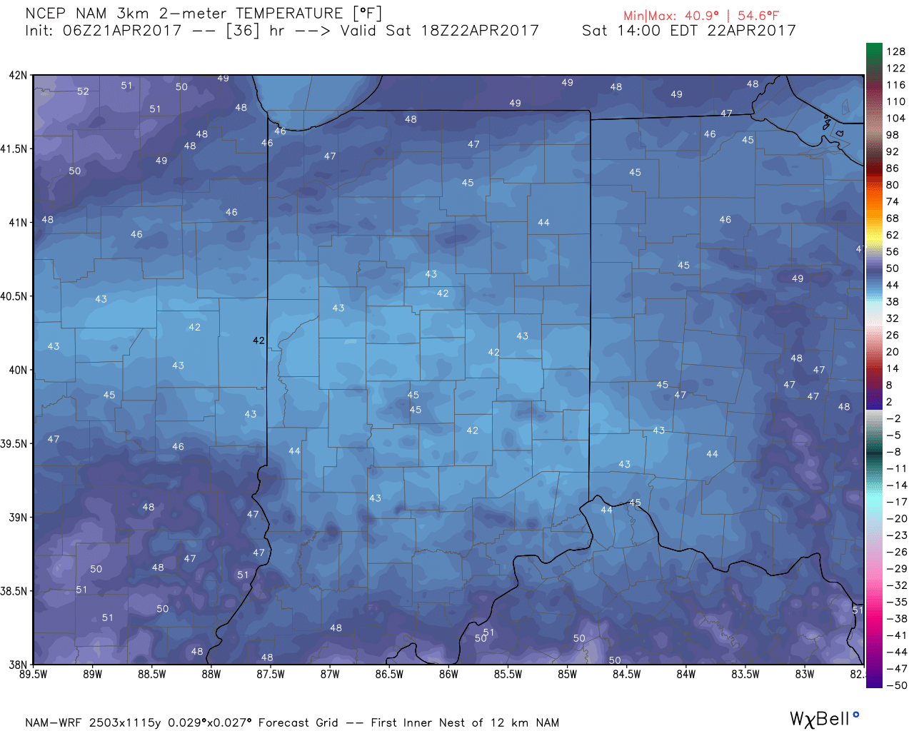
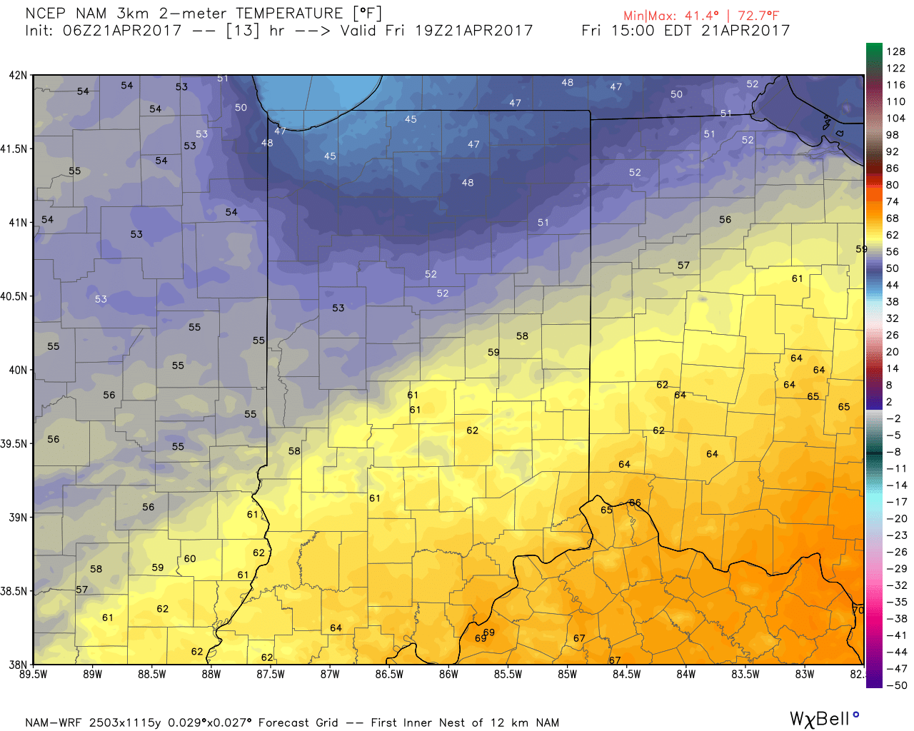 More widespread rain showers will move in overnight into Saturday. Heaviest rain will fall across the southern half of the state (1″-2″ possible). Factor in a strong and gusty easterly wind, temperatures only in the 40s for much of the day, and periods of rain and you have the makings for a downright “raw” Saturday.
 The good news here is that we still think things dry out for the second half of the weekend. The last round of showers should pull off to the east Saturday night and pave way for a dry Sunday, including increasing sunshine as morning gives way to afternoon.
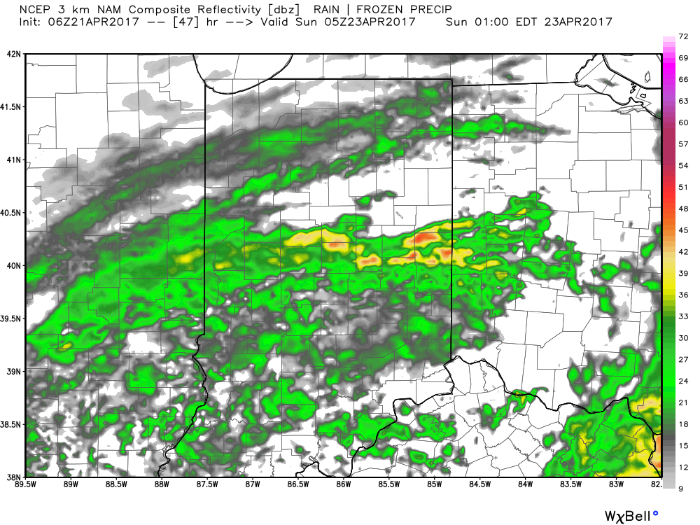 With the increasing sunshine Sunday, temperatures will respond closer to average highs in the middle 60s. After we spend most of Saturday in the 40s that sure will feel nice!
Permanent link to this article: https://indywx.com/2017/04/21/jackets-required-cool-and-increasingly-wet-close-to-the-week/
 Highlights:
- Strong storms possible Thursday afternoon
- Cooler close to the work week
- Raw Saturday
- Delightful open to next week
Thursday Rumbles…While storms have pressed through the northern portions of the state today, we’ve enjoyed a couple days of pleasant weather across most of central Indiana. That will come to an end Thursday as scattered to numerous showers and thunderstorms develop, especially during the afternoon into the evening hours. A few of these storms could become strong-to-severe, including damaging wind and large hail potential. The cold front will pass Thursday night and help usher in a briefly drier and much cooler air mass to close out the work week.
Our next storm system will pass south of the region Saturday and result in thickening and lowering clouds Friday evening, and showers Saturday. With a stiff east wind, showers at times, and temperatures well below average, we have the makings for a downright “raw” spring day Saturday. The second half of the weekend will easily be “the pick” as we return to drier air and increasing sunshine Sunday afternoon.
Early next week looks to get off to a pleasant start, including plentiful sunshine and moderating temperatures.
Upcoming 7-Day Precipitation Forecast:
- Snowfall: 0.00″
- Rainfall: 0.75″ – 1.25″
Permanent link to this article: https://indywx.com/2017/04/19/thursday-storms-before-a-cooler-trend/
 Highlights:
- Nice open to the week
- Midweek storms
- Wet, chilly weekend ahead
Pleasant Open To The Week…High pressure will slowly build into the Ohio Valley through early portions of the work week. Periods of clouds will be with us today before we clear things out in earnest tonight, resulting in a mostly sunny and beautiful Tuesday.
Our next storm system arrives Wednesday afternoon into Thursday morning with scattered thunderstorms. With a southerly wind flow in place, a touch of humidity can also be expected Wednesday afternoon. A cold front will pass early Thursday and result in a much cooler close to the work week.
Attention then shifts to our next storm system that will, unfortunately, arrive on the scene this weekend. Clouds will overspread the region Saturday and rain will develop. Early indications suggest we’ll also need to hit the wind and unseasonably cool air, as well for the weekend.
Upcoming 7-Day Precipitation Forecast:
- Snowfall: 0.00″
- Rainfall: 0.75″ – 1.25″
Permanent link to this article: https://indywx.com/2017/04/17/increasing-early-week-sunshine-raw-weekend-ahead/
 Highlights:
- Warm Easter weekend
- Scattered storms, but more dry time than wet
- Bigger storm system looms late next week
Summer-Feel This Weekend…The big weather story for the Easter weekend will be the unseasonably warm temperatures, including a “touch” of humidity for the first time this spring. That warmth and humidity will aid in storm development, at times, this weekend, but the balance of the holiday weekend will be rain-free.
We think best storm coverage comes this evening (primarily after the evening rush) and again on Easter Sunday. While an isolated storm is possible Saturday, most of the day should be dry.
A cold front will sweep through the state Easter evening and help set-up a dry, slightly cooler regime to open the new work week. Dry conditions remain Tuesday before scattered storms return to the forecast Wednesday. A bigger, more significant storm system looms by the end of next week and could result in heavy rainfall totals. We’ll keep an eye on things.
Upcoming 7-Day Precipitation Forecast:
- Snowfall: 0.00″
- Rainfall: 0.50′ – 1.00″
Permanent link to this article: https://indywx.com/2017/04/14/warm-easter-weekend/
 Highlights:
 Highlights:
 Highlights:
 Highlights:
 Highlights:
 Highlights:
 It’ll be a much cooler day today (temperatures are running close to 20° cooler than this time Thursday morning) with highs only topping out around 60 for the city, itself, and only into the mid to upper 50s across north-central Indiana.
 More widespread rain showers will move in overnight into Saturday. Heaviest rain will fall across the southern half of the state (1″-2″ possible). Factor in a strong and gusty easterly wind, temperatures only in the 40s for much of the day, and periods of rain and you have the makings for a downright “raw” Saturday.
 The good news here is that we still think things dry out for the second half of the weekend. The last round of showers should pull off to the east Saturday night and pave way for a dry Sunday, including increasing sunshine as morning gives way to afternoon.
 With the increasing sunshine Sunday, temperatures will respond closer to average highs in the middle 60s. After we spend most of Saturday in the 40s that sure will feel nice!
 Highlights:
 Highlights:
 Highlights: