Category: Forecast

A Closer Look At Two Winter Weather Events.

Your updated, custom-built, Thursday video forecast can be found to the right of this post in the video player.  We typically update our video forecast during the evening.

Good Morning and happy Thursday!  We continue to monitor the latest data for our upcoming winter weather events.  It’s a busy time of things and by the looks of the overall pattern, I’ll have to stock up on the coffee for the weeks ahead.  Quite honestly, a very cold and snowy pattern appears to be setting up shop now through the end of the month.  Anyone dreaming of a white Christmas? 😉

Here are some quick bullet points for the upcoming few days:

  • Snow/ sleet overspreads the region this evening
  • (2) waves of snow/ sleet move through the region between this evening and Friday
  • Saturday will be a very cold and dry day
  • Renewed snow and potentially freezing drizzle move in Sunday
  • We continue to forecast a total of 3-6″ of snow between tonight and Monday morning

Latest forecast models continue to suggest temperatures fall through the day with a mixture of snow and sleet overspreading the region as early as 3-5pm from southwest to northeast.  We anticipate a rather rapid transition from sleet to snow, especially from IND and points north.  Here’s a look at the latest HRRR simulated radar data, valid tonight at 6 o’clock:

hrrr_ref_indy_15

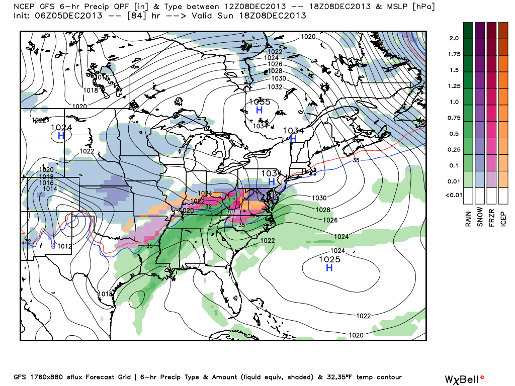
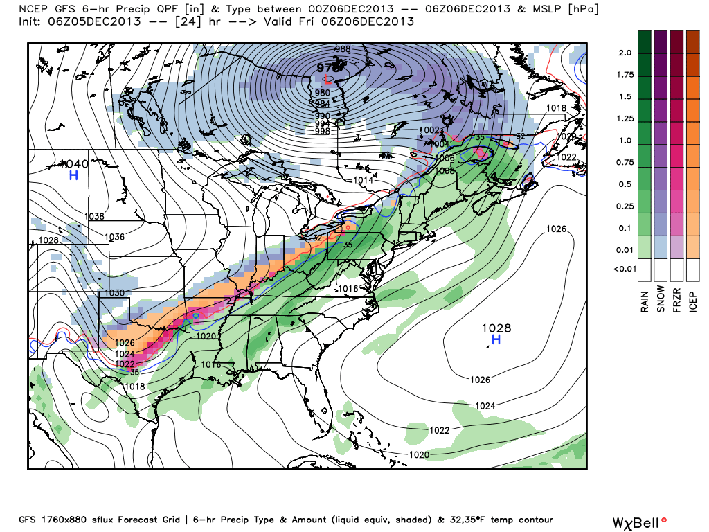
Here’s a look at the GFS model.  (We think this particular model has a much better handle on things now that we’re closer to the event).  Note the “waves” of wintry precipitation forecast and we agree with this.  Wave #1 arrives for the evening rush with wave #2 arriving Friday morning into the afternoon.

GFS1GFS2GFS3

Additionally, after a very cold and dry Saturday, renewed accumulating snow will overspread the region Sunday, potentially ending as a mixture of light freezing rain or freezing drizzle atop the fresh snow Sunday afternoon.

GFS4GFS5

Permanent link to this article: https://indywx.com/a-closer-look-at-two-winter-weather-events/

Wednesday Morning Weather Rambles…

1.) Fog will hang tough this morning, but strong southerly winds will blow this afternoon and help the fog burn off.  2.) With the cold and snow talk ahead, be…

You must be logged in to view this content. Click Here to become a member of IndyWX.com for full access.  Already a member of IndyWx.com All-Access?  Log-in here.

Permanent link to this article: https://indywx.com/wednesday-morning-weather-rambles/

Video Model Discussion On Upcoming Wintry Threat

  Tonight we discuss the various model solutions for the upcoming wintry pattern ahead Friday through Monday.  This is the data that helped us come to an official IndyWx.com forecast…

You must be logged in to view this content. Click Here to become a member of IndyWX.com for full access.  Already a member of IndyWx.com All-Access?  Log-in here.

Permanent link to this article: https://indywx.com/video-model-discussion-on-upcoming-wintry-threat/

Clouds Today; Snow Showers For The Big Travel Day

Good morning and happy Tuesday, Hoosiers!  Yesterday’s forecast went as planned with most folks not receiving any snowfall accumulation and a couple reports of a dusting to half an inch type snow.  We saw a couple local weather sources forecasting 1″ of snow and never understood that call as a lot of dry air had to be overcome initially.

Today will feature lots of clouds and another cold day as we watch a big southern storm begin to “make the curve” and impact the interior east.  Places as close as eastern Ohio will deal with heavy snow tonight and early Wednesday.  Additionally, locations as far south as east Tennessee will have accumulating snow by late tonight and early Wednesday.

Back here on the “home front” we’re looking at our next chance of snow arriving Wednesday afternoon.  The wind trajectory off Lake Michigan should allow a couple of lake-enhanced snow bands to push south into north-central Indiana, primarily from IND and points north.  It’s impossible to pinpoint with any degree of certainty the precise locations of these snow bands, but should your neighborhood end up under one of these snow squalls, don’t be surprised if you pick up a quick coating to 1″ of snow Wednesday afternoon/ evening.

Most model data (below) shows the lake-enhanced snow showers and embedded heavier squalls arriving Wednesday afternoon.  We’ll have a complete forecast update (and probable video) here later tonight.  Make it a great day.

hires_ref_indy_30snow1snow2

Permanent link to this article: https://indywx.com/clouds-today-snow-showers-for-the-big-travel-day/

Monday Forecast: A Calmer, Colder Week Ahead…

Updated 11.17.13 @ 8:46pm

Zionsville, IN Sunday was a violent day across central Indiana, including multiple tornado touchdowns (Lebanon and Kokomo, for example), heavy rain (widespread 1″+ totals), and damaging straight line winds (numerous trees and power lines down across the region, fueled by 70-80 MPH wind gusts).

Thankfully the new work week will dawn with a much calmer weather pattern in place, albeit much cooler.  High pressure will dominate our region, featuring dry and mostly sunny conditions both Monday and Tuesday.  Monday will still be a bit breezy and we’ll note a stronger push of cold air arriving Monday night, setting the stage for a seasonably chilly Tuesday and Wednesday.

Our next weather maker will arrive as we wrap up the work week. The culprit will be a cold front blowing through the Hoosier state and while model data differs significantly on precipitation totals in the Thursday-Friday time period, we’re confident in rain falling followed by a big blast of cold air for the weekend.

Looking ahead to Thanksgiving week, the threat is there for some wintry “mischief” as southern branch low pressure attempts to attack the cold high to our north… We have plenty of time to watch this, but just make a mental note in the back of your mind for now as you prep for Thanksgiving holiday travel.

Monday: Mostly sunny; 40/ 51

Status-weather-clear-icon


Tuesday: Mostly sunny; 29/ 48

Status-weather-clear-icon


Wednesday: Increasing afternoon cloudiness; 30/ 51

Status-weather-clouds-icon


Thursday: Cloudy and raw with rain likely; 43/ 49

Status-weather-showers-scattered-icon


Friday: Cloudy with rain likely; 44/ 49

Status-weather-showers-scattered-icon


Saturday: Mostly cloudy and colder; 30/ 39

images


Sunday:  Mostly sunny and cold; 19/ 30

Status-weather-clear-icon

Permanent link to this article: https://indywx.com/monday-forecast-a-calmer-colder-week-ahead/