Category: Forecast

October-Like Weekend…

Screen Shot 2015-09-10 at 7.53.17 AMHighlights:

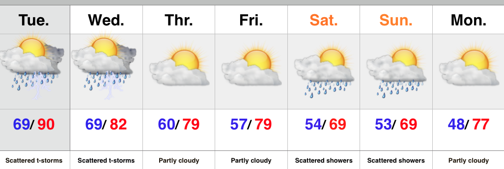
  • Dry day before showers arrive tonight
  • MUCH cooler weekend with showers around
  • Dry and pleasant early-mid next week

The first of two cold fronts pushed through the region last night and helped usher in late day clearing that set up a beautiful sunset across central IN.  The heat of September’s open is long gone and in it’s wake we can expect gorgeous weather today, with some sunshine before clouds increase later today.

A secondary cold front will sweep in to close the work week and this front will be responsible for delivering gusty showers Friday, followed by an airmass that’s more October-like than September over the weekend.  It’ll be a perfect weekend for football, chili, bonfires, and all things pumpkin! 🙂

Dry conditions return next week with moderating temperatures.

Upcoming 7-Day Rainfall Forecast: 0.50″

@Cryptics caught an amazing sunset last night, after what was a rather rainy, gloomy day.

Permanent link to this article: https://indywx.com/october-like-weekend/

Summer Like Now, But Fall Weather Is Coming…

Screen Shot 2015-09-07 at 9.57.37 PMHighlights:

  • Shower and storm chances
  • One-two punch of cooler air
  • Very fall-like weekend

A cold front is draped across the Plains this evening helping to ignite thunderstorms.  This front will slowly continue to push east and be responsible for increased chances of showers and thunderstorms across our neck of the woods late Tuesday into Wednesday.  We think a rather large area of showers and thunderstorms will diminish in intensity and coverage as it pushes across the state Tuesday night.  For an area that’s grown dry as of late, that’s not the news we want to hear.  There will be another opportunity for showers and thunderstorms to develop ahead of the frontal boundary that passes late Wednesday.

Drier and cooler weather will build in to close the work week, but a secondary push of cool, autumn-like air will arrive in time for the weekend.  Add in some upper level energy and we’ll need to mention a passing shower Saturday and Sunday.  It’ll feel drastically different this weekend that what we experienced last weekend.  Pumpkin spice latte, anyone? 🙂

Upcoming 7-Day Rainfall Forecast:  0.25″ – 0.50″

Permanent link to this article: https://indywx.com/summer-like-now-but-fall-weather-is-coming/

Thunderstorms, Especially West…

Screen Shot 2015-09-05 at 9.51.02 AMHighlights:

  • Western storms
  • Hot Labor Day
  • MUCH cooler late next week

Thunderstorms will slowly push south this morning, especially across western portions of the state.  Many will be asking “what storms?” while others are getting pounded by heavy rain, vivid lightning, small hail, and strong winds.  Best chances of getting a storm will be along and west of I-65.

Drier conditions will build in for the second half of the weekend and into early next week.  Labor Day will be a very hot and humid one.

Rain and storm chances will increase as we push into the mid week stretch as a strong cold front moves into the Mid West.  MUCH cooler air will infiltrate the state late next week and things will be feeling very “fallish” by the weekend.

Upcoming 7-Day Rainfall Forecast: 0.50″-1″ (locally heavier totals)


Permanent link to this article: https://indywx.com/thunderstorms-especially-west/

Summer Like Now, But Cooler Times Loom…

Screen Shot 2015-09-04 at 7.59.33 AMHighlights:

  • Storm potential north
  • Hot Labor Day weekend
  • Cold front delivers storms and cooler air next week

We’re off to another steamy one this morning with many neighborhoods already between 65-70 as we type this predawn Friday.  We’ll zoom up yet again to around 90 this afternoon with only isolated storm coverage.  Better chances of rain and storms can be expected across northeastern portions of the state due to a little “weakness” in the atmosphere.

The story for the long holiday weekend is one of heat and humidity, with little, if any, storm threat (very isolated coverage).  Highs Saturday though Monday should reach around 90.

However, changes are coming down the road as a significant cold front sweeps the region Wednesday into Thursday.  Showers and thunderstorms will accompany the frontal passage followed by a MUCH cooler, fall-like, air mass arriving by the end of next week.

Upcoming 7-Day Rainfall Forecast: 0.50″ – 1″

Permanent link to this article: https://indywx.com/summer-like-now-but-cooler-times-loom/

Hot With Isolated Storms…

Screen Shot 2015-09-03 at 7.55.33 AMHighlights:

  • Hot and humid conditions continue
  • Isolated storm coverage
  • Cold front approaches next week

In the short term, heat and humidity remain the big weather story as we head into the long Labor Day weekend, and unofficial end of summer.  BTW- meteorological summer ended Monday evening; however someone forgot to tell Mother Nature.  Isolated storm coverage will be present into the weekend.

The next big weather maker is on the horizon by the middle of next week in the form of a cold front.  Much better chances of more widespread showers and thunderstorms should precede the front before a much cooler air mass arrives late next week.

Upcoming 7-Day Rainfall Forecast: 0.50″ – 1″

Permanent link to this article: https://indywx.com/hot-with-isolated-storms/