Category: Forecast

Back To A Dry Pattern…

Screen Shot 2015-09-19 at 9.18.44 PMHighlights:

  • Dry conditions return
  • Moderating temperatures through the week

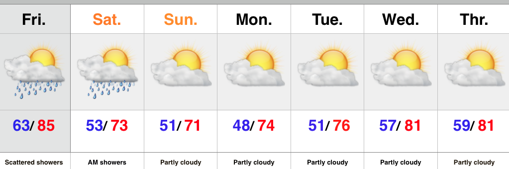
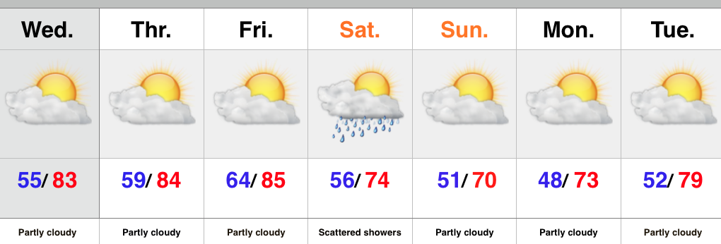
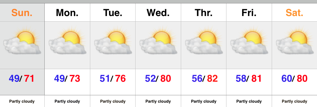
There’s no reason to waste a bunch of pixels on the forecast ahead.  High pressure is building in behind the cold front that moved through here Saturday morning.  As a result expect dry skies and mostly sunny conditions into next weekend.  The cooler, fall-like, air of the weekend will begin to moderate back to summer-like levels into the latter portion of the upcoming work week.

Upcoming 7-Day Rainfall Forecast: 0.00

Permanent link to this article: https://indywx.com/back-to-a-dry-pattern/

Cooler After A Few Showers…

Screen Shot 2015-09-17 at 9.31.12 PMHighlights:

  • Scattered showers around
  • Cooler air builds in Saturday
  • Still a dry pattern overall

As we wrap up the work week we notice a cold front off to our west.  This front will move through the region Saturday morning and will be accompanied by a broken band of showers.  More significant showers and thunderstorms will fall across northern IN as that portion of the state will be closer to an area of low pressure.  Across central IN, what once will look like an impressive line of showers and thunderstorms will weaken dramatically moving into the area.  The front will move through Saturday morning with a notable wind shift and cooler air Saturday afternoon/ evening that will remain into early next week.

Upcoming 7-Day Rainfall Forecast: 0.10″ – 0.25″


Permanent link to this article: https://indywx.com/cooler-after-a-few-showers/

Dry And Warm Now; Cooler Times Over The Weekend…

Screen Shot 2015-09-15 at 9.51.31 PMHighlights:

  • Dry times continue
  • Front comes through mostly dry
  • Weekend cooling

High pressure will remain in control into the latter portion of the work week before giving way to an approaching cold front late Friday.  Dry conditions will continue before we introduce showers into the picture late Friday night into early Saturday.  Unfortunately this doesn’t appear to be a significant rain maker, but we’ll take what we can get.  The bigger story will be the push of much cooler air that arrives Saturday evening into Sunday.

Upcoming 7-Day Rainfall Forecast: 0.10″ – 0.25″

Permanent link to this article: https://indywx.com/dry-and-warm-now-cooler-times-over-the-weekend/

Pleasant; Next Front Arrives At Week’s End…

Screen Shot 2015-09-14 at 8.33.01 PMHighlights:

  • Lots of sunshine
  • Rain chances begin to increase late Friday
  • Front sweeps the area Saturday with cooler air

We couldn’t have asked for a more glorious beginning to the work week, weather-wise.  We hope you had an opportunity to spend some of your Monday outdoors!  Thankfully, beautiful weather will prevail into the latter portion of the work week before clouds increase along with shower chances late Friday.  This is in association with our next cold front that will move through here Saturday.  We’re not looking at signifiant rain with this frontal passage, but another push of cool air will follow Saturday evening into early next week.

Upcoming 7-day Rainfall Forecast: 0.10″ – 0.25″

Permanent link to this article: https://indywx.com/pleasant-next-front-arrives-at-weeks-end/

Cool, Crisp Start; Dry Weather Continues…

Screen Shot 2015-09-13 at 8.34.01 AMHighlights:

  • Chilly start
  • Sunshine galore
  • Moderating temperatures

October-like weather will remain in place today, complete with wall-to-wall sunshine.  We suggest finding a way to get outside to watch the Colts kick off the season!  Dry conditions will remain with us for the balance of the work week before we introduce shower and thunderstorm chances into the forecast heading into next weekend.  Timing differences are there in regards to the arrival of our next cold front, but for now we’ll mention scattered showers and thunderstorms Friday and Saturday.

7-Day Rainfall Forecast: 0.25″ – 0.50″

Permanent link to this article: https://indywx.com/cool-crisp-start-dry-weather-continues/